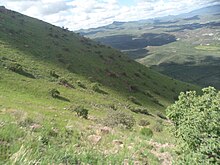
The Cerro Grande is a mountain range in Mexico. Located in the Sierra de Manantlán biosphere. It is located in the states of Colima and Jalisco. [1]
It has an elevation of 3093 metres. [2]
The Cerro Grande is a mountain range in Mexico. Located in the Sierra de Manantlán biosphere. It is located in the states of Colima and Jalisco. [1]
It has an elevation of 3093 metres. [2]
In the Cerro live multiple species: white-tailed deer (Odocoileus virginianus), gray fox ( Urocyon cinereoargenteus ) false scorpion ( Barisia imbricata ), the coralillo (Lampropeltis triangulum), the rattlesnake ( Crotalus basiliscus ),the jaguar ( Panthera onca ), the coati ( Nasua narica ) wild boar ( Pecari tajacu ), and the puma ( Puma concolor)

Tamaulipas, officially the Free and Sovereign State of Tamaulipas, is a state in Mexico; one of the 31 states which, along with Mexico City, comprise the 32 Federal Entities of Mexico. It is divided into 43 municipalities.

Comala is a town and municipality located in the Mexican state of Colima, near the state capital of Colima. It has been nicknamed the "White Village of America" as the façades of the buildings in town have all been painted white since the 1960s. The historic center of the town was declared a Historic Monument Zone and the town became a Pueblo Mágico in 2002. It is the municipal seat of the Comala Municipality, the local governing authority for over 400 other communities, including the former Nogueras Hacienda, the home of artist Alejandro Rangel Hidalgo.

The Sierra Madre Oriental is a mountain range in northeastern Mexico. The Sierra Madre Oriental is part of the American Cordillera, a chain of mountain ranges (cordillera) that consists of an almost continuous sequence of mountain ranges that form the western "backbone" of North America, Central America, South America, and Antarctica.

The Sierra Madre del Sur is a mountain range in southern Mexico, extending 1,000 kilometres (620 mi) from southern Michoacán east through Guerrero, to the Isthmus of Tehuantepec in eastern Oaxaca.

The Sierra Morena is one of the main systems of mountain ranges in Spain. It stretches for 450 kilometres from east to west across the south of the Iberian Peninsula, forming the southern border of the Meseta Central plateau and providing the watershed between the valleys of the Guadiana to the north and the west, and the Guadalquivir to the south.

The Sierra Madre Oriental pine–oak forests are a temperate broadleaf and mixed forest ecoregion of northeastern and Central Mexico, extending into the state of Texas in the United States.

The Trans-Mexican Volcanic Belt pine–oak forests is a subtropical coniferous forest ecoregion of the Trans-Mexican Volcanic Belt of central Mexico.
The Central American pine–oak forests is a tropical and subtropical coniferous forests ecoregion in the mountains of northern Central America and Chiapas state in southern Mexico.

Tlaxiaco is a city, and its surrounding municipality of the same name, in the Mexican state of Oaxaca. It is located in the Tlaxiaco District in the south of the Mixteca Region, with a population of about 17,450.
Luvianos is a small town and municipality located in the southwest of the State of Mexico. It gained municipal status in 2000. People can access Luvianos by driving Federal Road 134 south from Toluca, and then take a detour about 25 minutes north of Tejupilco. The name is derived from a hacienda what was established during colonial times.

Huehuetoca is a municipio (municipality) in State of Mexico, central Mexico, and also the name of its largest town and municipal seat.

Tenango de Doria is a town and one of the 84 municipalities of Hidalgo, in central-eastern Mexico. The municipality covers an area of 210.7 km².
Under UNESCO’s Man and the Biosphere Programme, there are 125 biosphere reserves recognized as part of the World Network of Biosphere Reserves in Latin America and the Caribbean. These are distributed across 21 countries in the region.

The Sierra de la Ventana is a mountain range in Buenos Aires Province, and one of only two located within the Pampas ecosystem.

Sierra de Quila, officially the Sierra de Quila Flora and Fauna Protection Area, is a Mexican Flora and Fauna Protection Area in the state of Jalisco, Mexico. It has an area of 15,193 hectares, and is located within six municipalities: San Martín de Hidalgo, Tecolotlán, Cocula, Atengo, Tenamaxtlán, and Ameca.

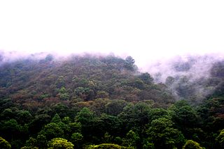
The Sierra de Manantlán Biosphere Reserve is a UNESCO Biosphere Reserve in the states of Colima and Jalisco, Mexico. The 139,577 hectares (538.91 sq mi) reserve is located in the transition of the Nearctic and Neotropical realms and encompasses parts of the Sierra Madre del Sur, with a wide range of altitudes, climates and soils. The effects of tectonic and volcanic activities and erosion are notable within the reserve.
This is a list of plants found in the Sierra de Manantlán Biosphere Reserve. The reserve straddles the Mexican states of Colima and Jalisco. It is located in the transition between the Nearctic and Neotropical realms and encompasses parts of the Sierra Madre del Sur, with a wide range of altitudes, climates and soils. The effects of tectonic and volcanic activities and erosion are notable within the reserve.
This page contains lists of reptiles found in the Sierra de Manantlán Biosphere Reserve, which straddles the states of Colima and Jalisco in Mexico. The reserve is located in the transition of the Nearctic and Neotropical realms and encompasses parts of the Sierra Madre del Sur, with a wide range of altitudes, climates and soils. The effects of tectonic and volcanic activities and erosion are notable within the reserve.

The Sierra Fría is a mountain range in central Mexico. It forms the northwestern border of Aguascalientes state and extends into adjacent Zacatecas, west of the city of Aguascalientes.