
Questa is a village in Taos County, New Mexico, United States. The population was 1,770 at the 2010 census. The village has trails into the Rio Grande Gorge, trout fishing, and mountain lakes with trails that access the Sangre de Cristo Mountains that overlook the area. Questa is on the Enchanted Circle Scenic Byway, near the confluence of the Rio Grande and the Red River. The "Gateway to the Rio Grande del Norte Monument", its visitors can drive to an overlook of the Red River meeting the Rio Grande in the depth of the gorge. The Carson National Forest parallels Questa to the east. The Columbine Hondo Wilderness and Latir Peak Wildness are in the Carson National Forest close to Questa.

The Western Slope is a colloquial term generally understood to describe the part of the state of Colorado west of the Continental Divide. Bodies of water west of the Divide flow toward the Pacific Ocean; water that falls and flows east of the Divide heads east toward the Gulf of Mexico. The Western Slope encompasses about 33% of the state, but has just 10% of the state's residents. The eastern part of the state, including the San Luis Valley and the Front Range, is the more populous portion of the state.

The Sierra Madre Oriental is a mountain range in northeastern Mexico. The Sierra Madre Oriental is part of the American Cordillera, a chain of mountain ranges (cordillera) that consists of an almost continuous sequence of mountain ranges that form the western "backbone" of North America, Central America, South America, and Antarctica.

The Sierra Madre del Sur is a mountain range in southern Mexico, extending 1,000 kilometres (620 mi) from southern Michoacán east through Guerrero, to the Isthmus of Tehuantepec in eastern Oaxaca.

The Coconino National Forest is a 1.856-million acre United States National Forest located in northern Arizona in the vicinity of Flagstaff, with elevations ranging from 2,600 feet to the highest point in Arizona at 12,633 feet. Originally established in 1898 as the "San Francisco Mountains National Forest Reserve", the area was designated a U.S. National Forest by Pres. Theodore Roosevelt on July 2, 1908, when the San Francisco Mountains National Forest Reserve was merged with lands from other surrounding forest reserves to create the Coconino National Forest. Today, the Coconino National Forest contains diverse landscapes, including deserts, ponderosa pine forests, flatlands, mesas, alpine tundra, and ancient volcanic peaks.

The Black Elk Wilderness is a nature preserve located in the U.S. state of South Dakota. The wilderness was designated by an act of Congress in 1980. Managed by the U.S. Forest Service, Black Elk Wilderness is part of Black Hills National Forest. This 13,426 acre (54 km2) region is considered sacred to Native Americans, especially the Sioux and is named after Black Elk, an Oglala Sioux holy man. Mount Rushmore National Memorial is immediately to the north and much of the rest of the wilderness is bordered by other protected land under the jurisdiction of state and federal agencies.

The Sierra Madre Occidental pine–oak forests are a Temperate broadleaf and mixed forests ecoregion of the Sierra Madre Occidental range from the southwest USA region to the western part of Mexico. They are home to a large number of endemic plants and important habitat for wildlife.

The Cerro Grande Fire was a prescribed-burn forest fire in Los Alamos, New Mexico, United States of America, that occurred in May of 2000. The fire started as a controlled burn on May 4, 2000, and became uncontrolled owing to high winds and drought conditions. Over 400 families in the town of Los Alamos, New Mexico, lost their homes in the resulting 58,000 acre fire. Structures at Los Alamos National Laboratory were also destroyed or damaged, although without loss or destruction of any of the special nuclear material housed there. No loss of human life occurred. The US General Accounting Office estimated total damages at $1 billion.

The Chumash Wilderness is a 38,150 acres (15,440 ha) wilderness area within the southern Los Padres National Forest. It is located in the Transverse Ranges, in northern Ventura County and southwestern Kern County in California.
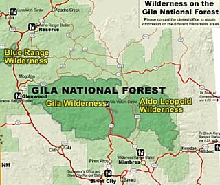
Gila Wilderness was designated the world's first wilderness area on June 3, 1924. Along with Aldo Leopold Wilderness and Blue Range Wilderness, the 558,014 acre wilderness is part of New Mexico's Gila National Forest. The wilderness is approximately 27 miles (43 km) from north to south and 39 miles (63 km) east to west.

The Monument Rock Wilderness Area is a wilderness area within the Malheur and Wallowa–Whitman national forests in the Blue Mountains of eastern Oregon. It was designated by the United States Congress in 1984 and comprises 19,650 acres (7,950 ha). There are approximately 15 miles (24 km) of trails maintained in the wilderness.
The Pecos Wilderness is a protected wilderness area within the Santa Fe National Forest and Carson National Forest. The Pecos Wilderness lies within the Camino Real Ranger District of the Carson National Forest, and the Pecos Ranger District and Espanola Ranger District of the Santa Fe National Forest. The Pecos Wilderness includes the southernmost extension of the Rocky Mountains in the sub-range of the Sangre de Cristo Mountains of north central New Mexico. One trail head for the wilderness is only 15 miles by road from Santa Fe, the state capital. Covering an area of 223,667 acres (90,515 ha)(350 sq mi) it is the second largest wilderness in the state after the Gila Wilderness. An area of fewer than 200,000 acres (81,000 ha) was given wilderness protection by Congress in 1964. Congress protected an additional 55,000 acres (22,000 ha) in 1980. The Wilderness boasts one of the highest concentrations of peaks exceeding 12,000 feet (3,700 m) in elevation in New Mexico, including Santa Fe Baldy, 12,622 feet (3,847 m), the highest point in Santa Fe County, and South Truchas Peak, 13,102 feet (3,993 m), the second highest peak in the state.
The Central American pine–oak forests is a tropical and subtropical coniferous forests ecoregion in the mountains of northern Central America and Chiapas state in southern Mexico.

The Snow Mountain Wilderness is a 60,076-acre (243.12 km2) federally designated wilderness area located 65 miles (105 km) north of Santa Rosa, California, USA in the Mendocino National Forest. The U.S. Congress passed the California Wilderness Act of 1984 which created 23 new wilderness areas including Snow Mountain. It lies within the North Coast Range of mountains.

The San Ysidro Mountains are a mountain range in southern San Diego County, California, and Baja California, Mexico. The mountains are a rugged coastal foothill range of the Peninsular Ranges system. Major peaks include the highest summit of the range, Otay Mountain, and the Cerro San Isidro which forms the southern extrusion of the range on the Mexican side of the border. The majority of the range is within the Otay Mountain Wilderness area, in the United States.

Cerro Grande is a 10,207-foot (3,111 m) summit on the rim of the Valles Caldera not far north of New Mexico State Road 4, the main highway through Los Alamos County. Like many mountains in the Jemez, Cerro Grande was mainly covered with coniferous forest, composed largely of ponderosa pine and aspen trees, with a characteristic rincon (meadow) on its slopes on and south of the summit.

Manzano Mountain Wilderness is a designated Wilderness Area within the Cibola National Forest, located about 50 miles (80 km) south-southeast of Albuquerque. It is located in western Torrance County and eastern Valencia County. The Wilderness area includes 36,875 acres (14,923 ha) with elevations ranging from 6,100 feet (1,900 m) to 10,098 feet (3,078 m) at Manzano Peak.

The Rio Grande del Norte National Monument is an approximately 242,555-acre (98,159 ha) area of public lands in Taos County, New Mexico, United States, proclaimed as a national monument on March 25, 2013, by President Barack Obama under the provisions of the Antiquities Act. It consists of the Rio Grande Gorge and surrounding lands, managed by the Bureau of Land Management (BLM).

San Antonio Mountain is a free-standing volcanic peak in Rio Arriba County, New Mexico. With an elevation of 10,908 feet, San Antonio Mountain is the highest peak within the Taos Plateau volcanic field, the largest volcanic field within the Rio Grande Rift valley.
Ute Mountain is a 10,093-foot elevation (3,076 m) summit located in Taos County, New Mexico, United States.
