Cervantes Islands

Last updated

The Cervantes Islands are a small group of islands in Western Australia, found to the south west of Cervantes.

Western Australia state in Australia

Western Australia is a state occupying the entire western third of Australia. It is bounded by the Indian Ocean to the north and west, and the Southern Ocean to the south, the Northern Territory to the north-east, and South Australia to the south-east. Western Australia is Australia's largest state, with a total land area of 2,529,875 square kilometres, and the second-largest country subdivision in the world, surpassed only by Russia's Sakha Republic. The state has about 2.6 million inhabitants – around 11 percent of the national total – of whom the vast majority live in the south-west corner, 79 per cent of the population living in the Perth area, leaving the remainder of the state sparsely populated.

Cervantes, Western Australia Town in Western Australia

Cervantes is a town in Western Australia off Indian Ocean Drive about 198 kilometres (123 mi) north-north-west of the state capital, Perth in the Shire of Dandaragan local government area. At the 2011 census, Cervantes had a population of 467. The town was named after a ship that was wrecked nearby. The ship, in turn, was named after Miguel de Cervantes, author of Don Quixote.

Contents

Island group

The Cervantes Islands are a group of three individual islands:

The group sits within the Jurien Bay Marine Park [2] and the Turquoise Coast islands nature reserve group, a chain of 40 islands spread over a distance of 150 kilometres (93 mi). [1]

Jurien Bay Marine Park Protected area in Western Australia

The Jurien Bay Marine Park is a protected marine park that is located 200 to 300 kilometres north of Perth, off the coastal tip of the Wheatbelt region of Western Australia. The 82,375-hectare (203,550-acre) marine park was formally declared on 31 August 2003 and is situated along the Indian Ocean Drive that extends south from Green Head to the southern boundary of Nambung National Park. It includes many of the islands located in this region.

Turquoise Coast (Western Australia)

Turquoise Coast is a name attributed to a section of the coastline of Western Australia in the vicinity of Jurien Bay.

The islands are named for an American whaling ship that was wrecked off the North island in 1844. [3] The ship was named after the writer Miguel de Cervantes. [4]

Miguel de Cervantes Spanish novelist, poet, and playwright

Miguel de Cervantes Saavedra was a Spanish writer who is widely regarded as the greatest writer in the Spanish language and one of the world's pre-eminent novelists. His novel Don Quixote has been translated into over 140 languages and dialects; it is, after the Bible, the most-translated book in the world.

The Australian sea lion is known to inhabit the islands. [5]

Australian sea lion species of mammal

The Australian sea lion also known as the Australian sea-lion or Australian sealion, is a species of sea lion that is the only endemic pinniped in Australia. It is currently monotypic in the genus Neophoca, with the extinct Pleistocene New Zealand sea lion Neophoca palatina the only known congener. These sea lions are sparsely distributed through Houtman Arbrolhos Islands in Western Australia and The Pages Islands in Southern Australia. With a population estimated at around 14,730 animals, the Wildlife Conservation Act of Western Australia (1950) has listed them as “in need of special protection”. Their Conservation status is listed as endangered. These pinnipeds are specifically known for their abnormal breeding cycles, which are varied between 5 months breeding cycle and a 17-18 month aseasonal breeding cycle, compared to other pinnipeds which fit into a 12-month reproductive cycle. Females are either silver or fawn with a cream underbelly and males are dark chocolate brown with a yellow mane and are bigger than the females.

See also

Related Research Articles

Waychinicup National Park Protected area in Western Australia

Waychinicup National Park is in Western Australia, 404 kilometres (251 mi) southeast of Perth and 65 kilometres (40 mi) east of Albany. The park is bordered by the Southern Ocean to the south, Mount Manypeaks Nature Reserve to the east, and agricultural land to the north. Its coastline runs between Normans Beach and Cheynes Beach, near Bremer Bay. Bald Island Nature Reserve is located offshore nearby. The park offers and array of landscapes, from the rugged coast to boulder-strewn hilltops. Tree-filled, deeply-incised valleys have freshwater streams flowing through them, with moss-covered boulders. Facilities provided include a camping area and bush toilet near the inlet of the Waychinicup River.

West Cape Howe National Park Protected area in Western Australia

West Cape Howe National Park is a national park in Western Australia, 390 kilometres (240 mi) southeast of Perth. The park is found between Albany and Denmark within the City of Albany and in the Great Southern region.

Garden Island is a slender island about 10 kilometres (6 mi) long and 1.5 kilometres (0.9 mi) wide, lying about 5 kilometres (3 mi) off the Western Australian coast, to which it is linked by a man-made causeway.

Shark Bay bay of the Indian Ocean in Western Australia, designated as a world heritage area

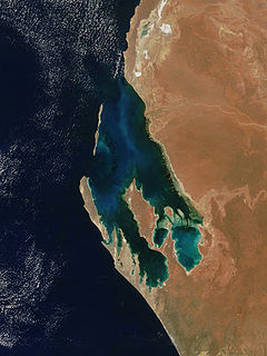
Shark Bay is a World Heritage Site in the Gascoyne region of Western Australia. The 2,200,902-hectare (5,438,550-acre) area is located approximately 800 kilometres (500 mi) north of Perth, on the westernmost point of the Australian continent. UNESCO's official listing of Shark Bay as a World Heritage Site reads:

St Alouarn Islands are a group of islands and rocks south-east of Cape Leeuwin in Western Australia, approximately 11 km south of Augusta in Flinders Bay.

Princess Royal Island island on the North Coast of British Columbia, Canada

Princess Royal Island is the largest island on the North Coast of British Columbia, Canada. It is located amongst the isolated inlets and islands east of Hecate Strait on the British Columbia Coast. At 2,251 square kilometres (869 sq mi), it is the fourth largest island in British Columbia. Princess Royal Island was named in 1788 by Captain Charles Duncan, after his sloop, the Princess Royal.

Algoa Bay

Algoa Bay is a bay in the Eastern Cape, South Africa. It is located in the east coast, 425 miles east of the Cape of Good Hope.

Broulee Island Nature Reserve Protected area in New South Wales, Australia

The Broulee Island Nature Reserve is a protected nature reserve located on the south coast of New South Wales, Australia. The 43 ha reserve was created in 1972 and is managed by the NSW National Parks & Wildlife Service. The reserve is situated 23 kilometres (14 mi) south of Batemans Bay and is adjacent to the village of Broulee.

Shire of Dandaragan Local government area in Western Australia

The Shire of Dandaragan is a local government area located in the Wheatbelt region of Western Australia, about 200 kilometres (124 mi) north of the state capital, Perth. The Shire covers an area of 6,716 square kilometres (2,593 sq mi) and its seat of government is the town of Jurien Bay.

Two Peoples Bay Nature Reserve

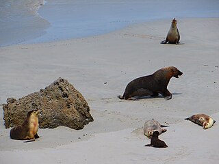
Two Peoples Bay Nature Reserve is a protected area managed by the Department of Parks and Wildlife 35 kilometres (22 mi) east of Albany, Western Australia. The area is accessible by 2WD vehicles. The bay itself, including two small secluded beaches, faces due east and is protected from the Southern Ocean by a headland formed by the granite massif of Mount Gardiner. The nature reserve was established in 1967 to protect the threatened noisy scrub-bird and its habitat.

Wedge Island (Western Australia) locality in Western Australia

Wedge Island is a settlement located north of Lancelin and south of Cervantes on the Western Australian coast.

Edwards Island (Western Australia)

Edwards Island, also known as Edward Island, is an island in Western Australia near Lancelin.

Lancelin Island

Lancelin Island is an island in Western Australia near Lancelin.

Beagle Islands (Western Australia)

The Beagle Islands are a small group of islands in Western Australia, found approximately 15 kilometres (9 mi) north west of Leeman.

Escape Island

Escape Island is an island near Jurien Bay in Western Australia.

Whitlock Island

Whitlock Island is an island near Jurien Bay in Western Australia.

Favorite Island

Favorite Island is an island in Western Australia.

Abutilon Island

Abutilon Island is located approximately 120 kilometres (75 mi) off the coast from Onslow in the Pilbara region of Western Australia.

Thevenard Island

Thevenard Island is located approximately 22 kilometres (14 mi) off the coast of Onslow in the Pilbara region of Western Australia.

References

  1. 1 2 "Turquoise Coast islands nature reserves management plan" (PDF). Government of Western Australia. 2004. Retrieved 14 December 2015.
  2. "Nambung National Park, Hangover Bay and Kangaroo Point". Pinnacles Visitor Centre. Retrieved 14 December 2015.
  3. "Shipwrecks Audio Transcript - Tilting at whales". Australian Broadcasting Corporation. 2003. Retrieved 14 December 2015.
  4. Maria Elena Knolle Cano. "The Spanish vs the Australian Cervantes". Spanish Australia Magazine. Retrieved 14 December 2015.
  5. "Seal Watching Tours". Lobster Shack. 2015.

Coordinates: 30°31′25″S115°2′40″E / 30.52361°S 115.04444°E / -30.52361; 115.04444

Geographic coordinate system Coordinate system

A geographic coordinate system is a coordinate system that enables every location on Earth to be specified by a set of numbers, letters or symbols. The coordinates are often chosen such that one of the numbers represents a vertical position and two or three of the numbers represent a horizontal position; alternatively, a geographic position may be expressed in a combined three-dimensional Cartesian vector. A common choice of coordinates is latitude, longitude and elevation. To specify a location on a plane requires a map projection.