Chahal, Guatemala

Last updated
San Fernando Nuevo Chahal
Guatemala location map.svg
Red pog.svg
San Fernando Nuevo Chahal
Location in Guatemala
Coordinates: 15°45′0″N89°34′0″W / 15.75000°N 89.56667°W / 15.75000; -89.56667
Country Flag of Guatemala.svg Guatemala
Department Bandera de Alta Verapaz.svg Alta Verapaz
Government
  MayorGonzalo Coc (LIDER)
Climate Af

Chahal is a municipality in the Guatemalan department of Alta Verapaz. The name originates from the Mayans.

Contents

History

Spanish conquest and the Dominican friars

On his second visit to Guatemala, in 1537, friar Bartolomé de las Casas, O.P. wanted to employ his new method of conversion based on two principles: 1) to preach the Gospel to all men and treat them as equals, and 2) to assert that conversion must be voluntary and based on knowledge and understanding of the Faith. It was important for Las Casas that this method be tested without meddling from secular colonists, so he chose a territory in the heart of Guatemala where there were no previous colonies and where the natives were considered fierce and war-like. Because it had not been possible to conquer the land by military means, the governor of Guatemala, Alonso de Maldonado, agreed to sign a contract promising that if the venture was successful he would not establish any new encomiendas in the area. Las Casas's group of friars established a Dominican presence in Rabinal, Sacapulas and Cobán, reaching as far as Chahal. Through the efforts of Las Casas' missionaries the so-called "Land of War" came to be called "Verapaz", "True Peace". Las Casas's strategy was to teach Christian songs to merchant Indian Christians who then ventured into the area. In this way he was successful in converting several native chiefs, among them those of Atitlán and Chichicastenango, and in building several churches in the territory named Alta Verapaz. These congregated a group of Christian Indians in the location of what is now the town of Rabinal. [1] In 1538 Las Casas was recalled from his mission by Bishop Francisco Marroquín who wanted him to go to Mexico and then on to Spain in order to seek more Dominicans to assist in the mission. [2]

Franja Transversal del Norte

"It is of public interest and national emergency, the establishment of Agrarian Development Zones in the area included within the municipalities: San Ana Huista, San Antonio Huista, Nentón, Jacaltenango, San Mateo Ixtatán, and Santa Cruz Barillas in Huehuetenango; Chajul and San Miguel Uspantán in Quiché; Cobán, Chisec, San Pedro Carchá, Lanquín, Senahú, Cahabón and Chahal, in Alta Verapaz and the entire department of Izabal."

Decree 60-70, first article. [3]

The first settler project in the Franja Transversal del Norte (FTN) was in Sebol-Chinajá in Alta Verapaz. Sebol, then regarded as a strategic point and route through Cancuén river, which communicated with Petén through the Usumacinta River on the border with Mexico and the only road that existed was a dirt one built by President Lázaro Chacón in 1928. In 1958, during the government of General Miguel Ydígoras Fuentes the Inter-American Development Bank (IDB) financed infrastructure projects in Sebol. [lower-alpha 1] In 1960, then Army captain Fernando Romeo Lucas García inherited Saquixquib and Punta de Boloncó farms in northeastern Sebol. In 1963 he bought the farm "San Fernando" El Palmar de Sejux and finally bought the "Sepur" farm near San Fernando. During those years, Lucas was in the Guatemalan legislature and lobbied in Congress to boost investment in that area of the country. [4]

In 1962, the DGAA became the National Institute of Agrarian Reform (INTA), by Decree 1551 which created the law of Agrarian Transformation. In 1964, INTA defined the geography of the FTN as the northern part of the departments of Huehuetenango, Quiché, Alta Verapaz and Izabal and that same year priests of the Maryknoll order and the Order of the Sacred Heart began the first process of colonization, along with INTA, carrying settlers from Huehuetenango to the Ixcán sector in Quiché. [5]

The Northern Transversal Strip was officially created during the government of General Carlos Arana Osorio in 1970, by Decree 60-70 in the Congress, for agricultural development. [6]

African oil palm

African oil palm plantation areas in Guatemala as of 2014. Guatemalapalma2014.JPG
African oil palm plantation areas in Guatemala as of 2014.

There is large demand in Guatemala and some of its neighbors for edible oils and fats, which explains how the African oil palm became so prevalent in the country to the detriment of other oils, and which has allowed new companies associated to large capitals in a new investment phase that can be found particularly in some territories that form the Northern Transversal Strip of Guatemala. [8] The investors are trying to turn Guatemala into one of the main palm oil exporters, in spite of the decline in its international price. The most active region is found in Chisec and Cobán, in Alta Verapaz Department; Ixcán in Quiché Department, and Sayaxché, Petén Department, where Palmas del Ixcán, S.A. (PALIX) is located, both with its own plantation and those of subcontractors. Another active region is that of Fray Bartolomé de las Casas and Chahal in Alta Verapaz Department; El Estor and Livingston, Izabal Department; and San Luis, Petén, where Naturaceites operates. [8]

Climate

Chahal has a tropical climate (Köppen: Af).

Climate data for Chahal
MonthJanFebMarAprMayJunJulAugSepOctNovDecYear
Mean daily maximum °C (°F)26.5
(79.7)
28.3
(82.9)
29.7
(85.5)
31.4
(88.5)
31.4
(88.5)
31.5
(88.7)
30.1
(86.2)
30.3
(86.5)
30.3
(86.5)
29.4
(84.9)
27.7
(81.9)
26.9
(80.4)
29.5
(85.0)
Daily mean °C (°F)22.8
(73.0)
23.6
(74.5)
25.0
(77.0)
26.4
(79.5)
26.9
(80.4)
27.2
(81.0)
26.4
(79.5)
26.4
(79.5)
26.3
(79.3)
25.6
(78.1)
24.1
(75.4)
23.0
(73.4)
25.3
(77.6)
Mean daily minimum °C (°F)19.2
(66.6)
19.0
(66.2)
20.4
(68.7)
21.5
(70.7)
22.5
(72.5)
22.9
(73.2)
22.7
(72.9)
22.5
(72.5)
22.3
(72.1)
21.8
(71.2)
20.5
(68.9)
19.1
(66.4)
21.2
(70.2)
Average precipitation mm (inches)135
(5.3)
80
(3.1)
75
(3.0)
78
(3.1)
190
(7.5)
430
(16.9)
487
(19.2)
322
(12.7)
339
(13.3)
294
(11.6)
197
(7.8)
154
(6.1)
2,781
(109.6)
Source: Climate-Data.org [9]

Geographic location

See also

Notes and references

  1. Sebol finally adopted the name "Fray Bartolomé de las Casas', municipality created in 1983 in Alta Verapaz.

Related Research Articles

<span class="mw-page-title-main">Alta Verapaz Department</span> Department of Guatemala

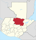
Alta Verapaz is a department in the north central part of Guatemala. The capital and chief city of the department is Cobán. Verapaz is bordered to the north by El Petén, to the east by Izabal, to the south by Zacapa, El Progreso, and Baja Verapaz, and to the west by El Quiché.

<span class="mw-page-title-main">Cobán</span> Place in Alta Verapaz, Guatemala

Cobán, fully Santo Domingo de Cobán, is the capital of the department of Alta Verapaz in central Guatemala. It also serves as the administrative center for the surrounding Cobán municipality. It is located 219 km from Guatemala City.

<span class="mw-page-title-main">Livingston, Guatemala</span> Municipality and town in Izabal Department, Guatemala

Livingston is a town, with a population of 17,923, in Izabal Department, eastern Guatemala, at the mouth of the Río Dulce at the Gulf of Honduras. The town serves as the municipal seat of the municipality of the same name. It was Guatemala's main port on the Caribbean Sea before the construction of nearby Puerto Barrios.

<span class="mw-page-title-main">Fernando Romeo Lucas García</span> 37th President of Guatemala from 1978 to 1982

General Fernando Romeo Lucas García was a military officer and politician who served as president of Guatemala from July 1, 1978, to March 23, 1982. He was elected as the nominee for the Institutional Democratic Party. Elections for his presidency were fraud-ridden. During Lucas García's regime, tensions between the radical left and the government increased. The military started to murder political opponents while counterinsurgency measures further terrorized populations of poor civilians.

Senahú is a town and municipality of the Department of Alta Verapaz in the Republic of Guatemala.

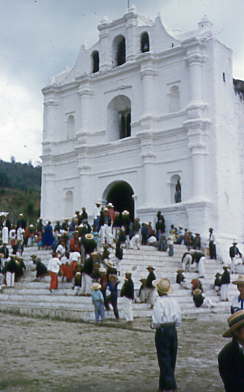
Cahabón is a municipality in the Guatemalan department of Alta Verapaz. It lies at an altitude of 250m above sea level and covers an area of 900 km². The population is 31,425. The annual festival is from September 1 to 8.

Chisec is a town and municipality in the north of the Guatemalan department of Alta Verapaz that was founded in 1813. It is situated at 230 metres (755 ft) above sea level. The municipality covers a territory of 1,244 km2.

Fray Bartolomé de las Casas is a municipality in the Guatemalan department of Alta Verapaz. The population is 31,611. It lies at an altitude of 170m above sea level and covers an area of 1,229 km². The annual festival is April 30-May 4. It is named after the 15th-century Spanish priest, bishop, and writer Bartolomé de Las Casas.

<span class="mw-page-title-main">San Agustín Lanquín</span> Municipality of Guatemala in Alta Verapaz

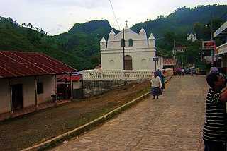
San Agustín Lanquín, often referred to simply as Lanquín, is a municipality in the Guatemalan department of Alta Verapaz. It lies at an altitude of 380 m above sea level. It has a population of about 16,500 people, many of Q'eqchi' Maya descent. It covers an area of 208 km².

<span class="mw-page-title-main">San Cristóbal Verapaz</span> Municipality in Alta Verapaz Department, Guatemala

San Cristóbal Verapaz is a town, with a population of 20,961, and a municipality in the Guatemalan department of Alta Verapaz. It is located approximately 29 km from Cobán, the capital of Alta Verapaz and about 210 km from Guatemala City. San Cristóbal belongs to the Pokimchi' linguistic area. Its main income source is the «Cobán» shoe factory, which specializes in industrial rubber boots, which are sold both locally and internationally.

<span class="mw-page-title-main">San Pedro Carchá</span> Municipality in Alta Verapaz, Guatemala

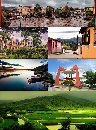
San Pedro Carchá, usually referred to as Carchá, is a town and a municipality in the Guatemalan department of Alta Verapaz. The municipality covers an area of 1,310 km2 and is situated at 1,282 m above sea level.

<span class="mw-page-title-main">Chajul</span> Municipality in El Quiché, Guatemala

Chajul is a town and municipality in the Guatemalan department of El Quiché. Chajul is part of the Ixil Community, along with San Juan Cotzal and Santa Maria Nebaj. The Ixil region is isolated by beautiful mountains and has maintained its rich Ixil Maya traditions and language. Chajul, Nebaj, and Cotzal make up the Ixil Region in the Department of Quiché in the Western Highlands of Guatemala. Having been at the heart of the 36-year civil war, Chajul experiences post-war challenges such as emotional trauma, land displacement, and fragmented families. Additionally, unemployment is high, large families live in one-room adobe houses with open cooking fires, opportunities for women are scarce, and family- and gender-based violence are common. The community has a corn-based agricultural economy in which adults struggle daily to feed their families and the average income is $1–3 per day. A 2002 study revealed that less than 1% of children graduate from high school as they are forced to leave school at a young age to help support the family household, leaving 75% of the adult population illiterate. Chajul further suffers from common preventable health concerns, such as respiratory illness, intestinal disease, tuberculosis, malnutrition, and death during childbirth. Eighty percent of the Chajul population lives in poverty.

Nentón is a town and municipality in the Guatemalan department of Huehuetenango. Its territory extends 717 km2 with a population of 45,679. It became a municipality on December 5, 1876 and was formerly known as San Benito Nentón. The population speaks Spanish and Chuj.

<span class="mw-page-title-main">Sayaxché</span> Municipality of Guatemala in El Petén

Sayaxché is a municipality in the El Petén department of Guatemala, on the Río La Pasión river. It covers an area of 3,904 square kilometres or 1,507 square miles, and had 55,578 inhabitants at the 2002 Census; the latest official estimate was 114,781 inhabitants.

<span class="mw-page-title-main">Morales, Guatemala</span> Municipality in Izabal Department, Guatemala

Morales is a municipality in Izabal Department of Guatemala. The municipality was created in 1920 and is formed by the town of Morales, 9 villages and 56 rural communities. The Cuevas del Silvino National Park is located a few kilometers northeast of Morales.

<span class="mw-page-title-main">Los Amates</span> Municipality of Guatemala in Izabal Department

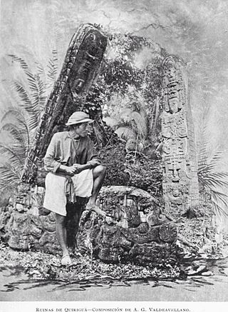
Los Amates is a municipality in the Izabal department of Guatemala. At the 2018 census, the population was 60,914. The mayor is currently Marco Tulio Ramirez Estrada. Los Amates is located on the Motagua River, 6 kilometres (3.7 mi) from the ruins of the ancient Maya city of Quiriguá.

El Estor is a town and a municipality in the Izabal department of Guatemala. As of the 2018 census, the town's population was 20,489. The population of El Estor consists largely of Qʼeqchiʼ speaking indigenous people.

<span class="mw-page-title-main">Ixcán</span> Municipality of Guatemala in El Quiché

Ixcán is a municipality in the Guatemalan department of El Quiché. Its administrative centre is the town of Playa Grande. The municipality consists of 176 communities, called aldeas. It has an area of 1,693 km2. It is the northernmost municipality of El Quiché, and borders with Mexico, the municipalities of Chisec and Cobán of the Department of Alta Verapaz, the municipality of Santa Cruz Barillas of the Department of Huehuetenango, and the municipalities of Chajul and Uspantán of El Quiché.

Raxruhá is a town and municipality in the north of the Guatemalan department of Alta Verapaz. The municipality, which was formerly a part of Chisec, was founded in 2008.

<span class="mw-page-title-main">Franja Transversal del Norte</span> Place in Guatemala

The Franja Transversal del Norte is a region in Guatemala delimited to the north by an imaginary line between Vértice de Santiago in Huehuetenango and Modesto Méndez Port in Izabal and in the south by La Mesilla in Huehuetenango and Izabal lake. It is composed, from west to east, of part of the Guatemalan departments of Huehuetenango, Quiché, Alta Verapaz and the entire department of Izabal. It extends roughly 15750 km2. During the Guatemalan Civil War, most of the massacres took place there due to the oil, mineral and precious wood reserves in the region. In the 21st century, there are projects to work in the region and a modern highway was built in 2010.

References

  1. Wagner & Parish 1967, pp. 86–93.
  2. Wagner & Parish 1967, pp. 94–95.
  3. Solano 2012, p. 15.
  4. Solano 2012, p. 10.
  5. Solano 2012, p. 13.
  6. "Franja Transversal del Norte". Wikiguate. Archived from the original on 2014-07-04. Retrieved 30 October 2014.
  7. Solano 2015, p. 6.
  8. 1 2 Solano 2015 , p. 1
  9. "Climate: Chahal". Climate-Data.org. Retrieved 19 August 2015.
  10. 1 2 SEGEPLAN. "Municipios de Alta Verapaz, Guatemala". Secretaría General de Planificación y Programación de la Presidencia de la República. Guatemala. Archived from the original on 30 June 2015. Retrieved 30 June 2015.

Bibliography

  • Solano, Luis (2012). Contextualización histórica de la Franja Transversal del Norte (FTN) (PDF) (in Spanish). Centro de Estudios y Documentación de la Frontera Occidental de Guatemala, CEDFOG. Archived from the original (PDF) on 13 November 2014. Retrieved 31 October 2014.
  • Solano, Luis (15 July 2015). "Palma Africana" (PDF). Revista Enfoque. Guatemala (36). Archived from the original (PDF) on 20 July 2015. Retrieved 19 July 2015.
  • Wagner, Henry Raup; Parish, Helen Rand (1967). The Life and Writings of Bartolomé de Las Casas. University of New Mexico Press.

15°45′N89°34′W / 15.750°N 89.567°W / 15.750; -89.567