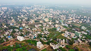
Khammam is the city in Khammam district of the Indian state of Telangana. It is the fourth largest city in the state. It is the headquarters of the Khammam district and Khammam mandal also. It is located about 193 kilometres (120 mi) east of the state capital, Hyderabad, 61 kilometres (38 mi) from Suryapet, 120 kilometres (75 mi) from Warangal and also it is located about 121 kilometres (75 mi) North of the Andhra Pradesh state capital, Amaravathi. The river Munneru flows on the western side of the city. As of 2011 census of India, Khammam urban agglomeration has a population of 313,504. However, on 19 October 2012, the civic body of Khammam was upgraded to a municipal corporation. Post- upgradation to corporation, the population of Khammam was approximated to be 3,07,000.
Yola, meaning 'Great Plain' or 'Vast Plain Land', is a large city, capital city and administrative centre of Adamawa State, Nigeria. It is located on the Benue River, and it has a population of over 336,648 (2010). Yola is split into two parts. The old town of Yola where the Lamido resides is the traditional city and the new city of Jimeta is the administrative and commercial centre. They are generally referred to as Yola.

Ongole is a city in Prakasam district of the Indian state of Andhra Pradesh. It is the headquarters of Prakasam district and also the mandal headquarters of Ongole mandal in Ongole revenue division. Ongole cattle, an indigenous breed of oxen, derived their name from Ongole.

The climate of India consists of a wide range of weather conditions across a vast geographic scale and varied topography. Based on the Köppen system, India hosts six major climatic sub types, ranging from arid deserts in the west, alpine tundra and glaciers in the north, and humid tropical regions supporting rain forests in the southwest and the island territories. Many regions have starkly different microclimates, making it one of the most climatically diverse countries in the world. The country's meteorological department follows the international standard of four seasons with some local adjustments: winter, summer, monsoon or rainy season, and a post-monsoon period.

The West Godavari district is a coastal district in the Indian state of Andhra Pradesh with an administrative headquarters in Bhimavaram. As of the 2011 Census of India, the district has an area of 2,178 km2 (841 sq mi) and a population of 1,779,935. It is bounded by the Krishna district and Bay of Bengal to the south, East Godavari district to the east, and Eluru district, Kolleru Lake and Upputeru Drain to the northwest.

Tadepalligudem is a city in West Godavari district of the Indian state of Andhra Pradesh. It is a Selection Grade municipality and the mandal headquarters of Tadepalligudem mandal and Tadepalligudem Revenue Division.
Kandukur or Kandukuru is a town in SPSR Nellore district of the Indian state of Andhra Pradesh. It is a municipality and the headquarters of Kandukur mandal as well as Kandukur revenue division. Kandukur Mandal is located at the south-east side of the Prakasam District having geographical area around 225 sq km.There is only 1 city in the Kandukur Mandal, which is Kandukur Municipality having an area of 37.63 sq km.
The climate of San Diego, California is classified as a hot-summer Mediterranean climate. The basic climate features hot, sunny, and dry summers, and cooler, wetter winters. However, San Diego is much more arid than typical Mediterranean climates, and winters are still dry compared with most other zones with this type of climate. The climate at San Diego International Airport, the location for official weather reports for San Diego, as well as the climate at most beach areas, straddles the border between BSh and BSk due to the mild winters and cool summers in these locations.
Gampalagudem is a town situated in the NTR district of Andhra Pradesh, India. It serves as the headquarters of the Gampalagudem mandal, which is under the administration of the Tiruvuru revenue division. The town is located on the banks of the Kattaleru river and is situated at a distance of 74 km (46 mi) from the district headquarters Vijayawada.
Tarana is a town and a nagar parishad in Ujjain district in the Indian state of Madhya Pradesh. Tarana is a tehsil in Ujjain and the distance to Ujjain is 34 km. Tarana was part of Holkar estate. The current M.L.A of Tarana constituency is Mahesh Parmar (INC).

The climate of Los Angeles is mild to hot year-round, and mostly dry. It is classified as a Mediterranean climate, which is a type of dry subtropical climate. It is characterized by seasonal changes in rainfall—with a dry summer and a winter rainy season. Under the modified Köppen climate classification, the coastal areas are classified as Csb, and the inland areas as Csa.

Mubi North is a Local Government Area of Adamawa State, Nigeria. The town is the location of the Adamawa State University and the Federal Polytechnic, Mubi.
Aba South is a Local Government Area of Abia State, Nigeria. Its headquarters are in the city of Aba.
Ife South is a Local Government Area in Osun State, Nigeria. Its headquarters are in the town of Ifetedo at 7°11′00″N4°42′00″E.
Ede North is a Local Government Area in Osun State, Nigeria. Its headquarters as Abere.
Kukunoor is a village in Eluru District of the Indian state of Andhra Pradesh. It was in Khammam district, until the formation of Telangana state in 2 June 2014.

Tangellamudi is a census town in Eluru district of the Indian state of Andhra Pradesh. It is in Eluru mandal of Eluru revenue division. The town is a constituent of Eluru urban agglomeration. The nearest railway station is in Powerpet and is 1.5 km.
Sreeparru is a village in Eluru district in the state of Andhra Pradesh in India. It is 22 km from the city of Eluru, the headquarters of Eluru district.
Pinakadimi is a village in Eluru district of the Indian state of Andhra Pradesh. It is located in Pedavegi mandal of Eluru revenue division. It is located at a distance of 7 km from district headquarters Eluru city.
Iperindo town is situated in the Osun region. Osogbo (Osogbo), the capital of Osun, lies about 42 kilometers from Iperindo. Iperindo and Abuja, the capital of Nigeria, are separated by a distance of roughly 341 kilometers.


