Chamberlain Bridge

Last updated
Chamberlain Bridge
Bridgetown barbados chamberlain bridge.jpg
Chamberlain Bridge, Bridgetown
Coordinates 13°05′46″N59°36′51″W / 13.0961°N 59.6141°W / 13.0961; -59.6141 Coordinates: 13°05′46″N59°36′51″W / 13.0961°N 59.6141°W / 13.0961; -59.6141
Carriespedestrians, bicycles
Crosses Constitution River
Careenage River
Locale Barbados
Official nameThe Chamberlain Bridge
The Swing Bridge.
Other name(s)Originally named as the Indian Bridge
Maintained byGovernment of Barbados
Characteristics
DesignFormer: Swing bridge
Current: Single-leaf bascule-type drawbridge [1]
Total length11.72 metres (38.5 ft)
Width8.86 metres (29.1 ft)
Longest spanSingle span of 11.7 metres (38 ft)
History
OpenedOriginally built in 1872 and rebuilt in 2005–2006
Statistics
TollN/A
Location
Chamberlain Bridge

The Chamberlain Bridge is a bridge in Bridgetown, the capital and largest city of the nation of Barbados. In 1872, it was a swing bridge across the marine inlet channel of the inner basin of the Careenage (Constitution River) at Carlisle Bay. [2] The outmoded steel structure was dismantled and rebuilt in 2005–2006 [3] as a lifting bridge with the state-of the-art modern technology of an all-composite single-leaf [1] bascule design. [4] This design is a counterweighted bridge span that pivots upward, permitting pleasure craft to pass through an inlet channel. [5] The bridge was built using fibre-reinforced plastic (FRP), which is lighter, long lasting and non-corrosive. [6]

Contents

There are two bridges in use in Bridgetown. The Charles Duncan O'Neal Bridge is large and modern in design, commencing from the street east of National Heroes Square, while Chamberlain Bridge is the more "decorative humpbacked bridge" built to replace the original swing bridge after the Great Hurricane with funds generated through the efforts of the then British Colonial Secretary, Joseph Chamberlain (1836–1914). [7]

Etymology

The swing bridge replaced an old wooden bridge named “Indian Bridge,” which ushered development through the movement of small boats into the inner basin of the Careenage River. The bridge was later renamed after Joseph Chamberlain, who, as the British Colonial Secretary in the 1890s, was instrumental in shielding the West Indian sugar industry against stiff competition from Europe. [2] He is also credited with allocation of large funds as grants and loans to subsist the economy of Barbados. [6]

The town was officially known as the "town of St. Michael", but was later renamed as Bridgetown after the bridge. Indeed, the town was known as Indian Bridgetown or Indian Town for some time after this bridge. [8] [9]

History

The history of this bridge is recorded by Warren Alleyne in his book Historic Bridgetown. [10] According to Alleyne, a primitive bridge, built by the indigenous Arawak, was replaced in 1628 by the Wolverstone settlers. It was rebuilt in 1654 after its condition deteriorated. Subsequently, fires gutted the bridge and it had to be rebuilt again in 1668. The problem was compounded by a hurricane in 1675 and again in 1677. This constant disruption caused inconvenience to traffic and prompted the authorities to build another bridge. The second bridge was built by levying a tax on the slaves. By 1681, Bridgetown had two bridges: the west bridge, which was built at the same location as the Indian Bridge (the present lift bridge), and the east bridge, built at the present site of the O'Neal Bridge.

The Commemorative Independence Arch Bridgetown 059.jpg
The Commemorative Independence Arch
18th century

Floods in 1700 destroyed the west bridge, resulting in only one bridge remaining as a link between the two banks of the river. [6] Fifty years later, in 1751, the second bridge was rebuilt but it also ended in disaster due to poor construction, which necessitated the authorities to prosecute the builders. This was followed by a bridge constructed in 1760 for pedestrians only.

19th century

In 1862, when Trafalgar Square (later renamed National Heroes Square) was gutted, a rebuilding exercise of the entire complex resulted in planning for a swing bridge also. Construction for the swing bridge started in 1865 but had to be dismantled as it did not conform to the approved design. This was followed by shipping over the metalwork manufactured in London in transportable sections, and assembling on site from both ends of the structure. This exercise also ended in controversy, as both ends could not be joined due to a gap. Eventually, the bridge was completed at a cost of 18,000 pounds which was then stated to be "a total mismanagement of public funds". The bridge was formally commissioned on April 18, 1872. A hurricane struck it in 1898, causing severe damage to the structure. [11] It was refurbished with funds granted by the British Government under Joseph Chamberlain, the then Secretary of State for the Colonies.

20th century

It was re-commissioned on December 14, 1900, by Lady Hay, wife of Sir James Shaw Hay, then Governor of Barbados. The bridge was also named in honour of the Secretary of State for the Colonies, as the "Chamberlain Bridge". It functioned until 1984, when it was declared unfit for traffic and it gradually deteriorated. [6]

"Oh Chamberlain! You deserve to rest now

And view all sorts of cargo passing by
In this temporal grove, the Careenage
Of still waters ‘neath arched extremities
With trade from Caricom communities;
As pleasure crafts sail with the cool sea breeze
For you give them shelter from angry seas.

To your north stand political towers,
The Cathedral and the heroes in the Square,
Your frame preserved the tracks, stains and bruises
Caused by every thing flowing over you;
Some have mishandled you and raped you too;
Yet your NISE arms swung with pride and beauty;
Your rest deserved; you have done your duty.

Oh Bridge of fragile frame you have reached now
One hundred and thirty-three years this fall.
With Indians' feathered quills they wrote ’bout
The blood, the sweat and tears of by-gone slaves,
Your blows from hurricanes and killer waves,
Yet your timbered heart did find common ground

With Wolferstone, and Chamberlain, profound!"

Three stanzas of Paterika Hengreaves's poem on the dismantling of Chamberlain Bridge in 2005. [12]

A commemorative arch commemorating the 21st anniversary of Barbados Independence was built in 1987 at the southern end of the bridge. This reduced the available width for the new swing bridge. [6] [13]

21st century

In 2005, it was decided to replace the old swing bridge with modern state-of-the art bridge technology. A plan was made to build the modern lifting bridge. It included dismantling the old swing bridge to make way for the new bridge, which was completed in 2006. [14] [15] The new lift bridge stretches from National Heroes Square to the other bank, permitting seagoing ships to dock in the inner basin of the river in the rebuilt Careenage.

Geography

The Carineege (outer basin) named by the "Bajans" as Constitution River Constitution River Careenage (Outer Basin).jpg
The Carineege (outer basin) named by the "Bajans" as Constitution River
Inner basin of the Constitution River Inner Basin of the Constitution River 005.jpg
Inner basin of the Constitution River

The Arawak Indians, the original inhabitants of Barbados, built a wooden bridge, the Arawak Indian bridge, across the inlet channel named the Constitution River or the Careenage River. Later, this part of the city became the waterfront where fishing and other commercial boats operated. Careenage inlet takes its name from the process of careening, in which weight would be tied to a ship’s mast to upturn it, exposing the hull so that it could be cleaned and painted. However, a deep-water harbour replaced the original harbour. [2] [16] [17] It is inferred that the draw bridge, which was constructed in 1872, was also built at the same location as the Arawak Indian bridge. [2] [16] [18]

The Constitution River is an arm of the bay where the Careenage marina was developed for ships to berth. The Careenege marina was the hub of all mercantile activity of Bridgetown till the new harbour at Bridgetown was built. Of the two bridges built across this river, the Chamberlain Bridge was built as a draw bridge to allow large ships to cruise through the inlet and its name is in honour of the Colonial Secretary who helped Barbados with financial assistance after the 1898 hurricane. [19]

While the importance of the Careenage River channel and the draw bridge across it was the nucleus of activity for inter-island trading vessels, its current use is mostly for operation of recreational crafts such as catamarans, yachts, fishing boats and so forth. Today, the bridge is used for pedestrians only and the boardwalk attached to the bridge stretches over the length of the wharf and used by pedestrians to get fine vistas of the town. [2] [16] [19]

Structure

The stone arch bridge and the modern bascule-type lift bridge Bridgetown 062.jpg
The stone arch bridge and the modern bascule-type lift bridge

The lift bridge was designed by Faber Maunsell to replace the bridge built in 1872. Several designs were considered. Finally, a unique design using fibre-reinforced plastic (FRP) composite known as the "space age material" was chosen. The basic composition of FRP is an engineered polymer or plastic with glass reinforcement with supplements of additives and core materials. The lightweight FRP material was found not only economical and strong but also durable, non-corrosive lightweight to suit the corrodible marine environment. It was designed to carry 7.5 tonne vehicular load with pedestrian loading. The lift bridge was designed as an all-composite double-leaf bascule bridge with custom design adopting “Strongwell's Composolite building panel system, Strongwell EXTREN structural shapes and a custom, heavy-duty building panel.” EXTREN square tubes of different sizes provided the attractive architectural railing on the sides.

The bridge was built in 2005–2006. The engineer in charge of implementation was Kandiah Kuhendran, with builder Richard Edghill. [3] The bridge measures 8.86 metres (29.1 ft) in width and of single span of 11.72 metres (38.5 ft) length and is about 1 metre (3 ft 3 in) deep. It was manufactured in four segments and assembled at site with “adhesive and Composolite toggles and 3-way connector.” [1] [5] Edghill, who built this bridge, said that "It's probably one of the first in the world using that material, for a national lift bridge." The FRP composite is a technology provides, a lighter and stronger structure with long life. The lift bridge as built is contiguous to the two old stone arches, which have been refurbished adding to the aesthetics of the bridge which have also been now provided with night lighting arrangements making the bridge locale an attractive scenic place to visit. [1] [20] The two span coral stone masonry arch structure dating from 1861 adjoins the lift bridge. [20] [21] The bridge has a plaque of the Barbadian National Anthem. [17]

Related Research Articles

Bridgetown Capital of Barbados

Bridgetown is the capital and largest city of Barbados. Formerly The Town of Saint Michael, the Greater Bridgetown area is located within the parish of Saint Michael. Bridgetown is sometimes locally referred to as "The City", but the most common reference is simply "Town". As of 2014, its metropolitan population stands at roughly 110,000.

Surf City, North Carolina Town in North Carolina, United States

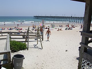
Surf City is a town in Pender and Onslow counties in the U.S. state of North Carolina. The population was at 1,853 at the 2010 census. It is located on Topsail Island.

Indian River (Delaware)

The Indian River is a river and estuary, approximately 15 mi (24 km) long, in Sussex County in southern Delaware in the United States. The river is named after a Native American reservation that was located on its upper reaches.

Charles Duncan O'Neal was a Barbados physician, political figure and labor rights activist. He founded the radical Democratic League in 1924 and influenced the shift towards party-focused politics still seen in Barbados today.

Bridgetown, Nova Scotia Community in Nova Scotia, Canada

Bridgetown is a Canadian community located in north-central Annapolis County, Nova Scotia.

Spuyten Duyvil Bridge Bridge between Manhattan and the Bronx, New York

The Spuyten Duyvil Bridge is a railroad swing bridge that spans the Spuyten Duyvil Creek between Manhattan and the Bronx, in New York City. The bridge is located at the northern tip of Manhattan where the Spuyten Duyvil Creek meets the Hudson River, approximately 1,000 feet (300 m) to the west of the Henry Hudson Bridge.

North Avenue Bridge

The North Avenue Bridge can refer to one of three bridges that has carried North Avenue over the North Branch of the Chicago River on the north side of Chicago, Illinois. A center-pier swing bridge built in 1877 was replaced in 1907 by a bascule bridge, allowing river traffic more room for maneuvering in and out of the North Canal, just north of Goose Island.

Fourteenth Street Bridge (Ohio River) Railroad bridge over the Ohio River between Louisville, Kentucky, and Clarksville, Indiana

The Fourteenth Street Bridge, also known as the Ohio Falls Bridge, Pennsylvania Railroad Bridge, Conrail Railroad Bridge or Louisville and Indiana (L&I) Bridge, is a truss drawbridge that spans the Ohio River, between Louisville, Kentucky and Clarksville, Indiana.

Cochrane–Africatown USA Bridge

The Cochrane–Africatown USA Bridge is a cable-stayed bridge carrying US 90/US 98 Truck across the Mobile River from the mainland to Blakeley Island in Mobile, Alabama.

Delaware Route 14 State highway in Kent County, Delaware, United States

Delaware Route 14 (DE 14) is a state highway in the southern part of Kent County, Delaware. The route runs from the Maryland border near Burrsville, Maryland, where the road continues as Maryland Route 317 (MD 317), east to DE 1 in Milford. The route passes through Harrington, where it intersects U.S. Route 13 (US 13), and passes to the north of Houston before coming to Milford, where it intersects DE 15, US 113, and DE 1 Business. DE 14 has a truck bypass of Harrington known as DE 14 Truck.

Tees Viaduct

The A19 Tees Viaduct or Tees Flyover is a high level six-lane dual carriageway road bridge in the North East of England carrying the main A19 trunk road north–south across the River Tees.

Lawrence C. Bank is the associate provost for research at The City College of New York and a professor in the Department of Civil Engineering at the Grove School of Engineering. He is a registered Professional Engineer in the State of Wisconsin and the District of Columbia. He is a Fellow of the American Society of Civil Engineers, as well as a Fellow and currently President of the International Institute for FRP Composites in Construction. Prior to joining CCNY, Bank was on the faculty of the University of Wisconsin–Madison, the Catholic University of America and Rensselaer Polytechnic Institute. He has worked as a structural engineer for Leslie E. Robertson and Associates in New York City and as a consultant for the composite materials industry.

Norwalk River Railroad Bridge United States historic place

The Norwalk River Railroad Bridge is a swing bridge built in 1896 for the New York, New Haven and Hartford Railroad. It currently carries Amtrak and Metro-North Railroad trains over the Norwalk River.

John Hillman, P.E. is an American structural engineer who invented the hybrid composite beam (HCB) and founded the HC Bridge Company. In 2010, he was recognized with the Award of Excellence from Engineering News-Record.

Charles Duncan ONeal Bridge

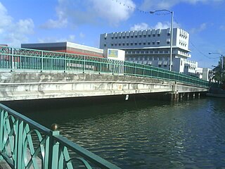
Charles Duncan O'Neal Bridge is a bridge in Bridgetown, Barbados. It is one of two bridges over the Careenage, the other being the Chamberlain Bridge, although unlike the Charles Duncan Bridge it does not take traffic. It is named after Charles Duncan O'Neal who founded the radical Democratic League in 1924.

Great Eddy Covered Bridge

The Great Eddy Covered Bridge, also called the Big Eddy Covered Bridge or Waitsfield Covered Bridge, is a wooden covered bridge that crosses the Mad River in Waitsfield, Vermont on Bridge Street. Built in 1833, it is one of Vermont's oldest covered bridges. It was listed on the National Register of Historic Places in 1974.

2003 Pan American Junior Athletics Championships

The 12th Pan American Junior Athletics Championships were held in Bridgetown, Barbados at the National Stadium on 18–20 July 2003. Jamaican sprinter Usain Bolt had the outstanding performance equalling the 200m World Junior record, while the team of the USA dominated the championships gaining 48 medals.

Cherry Street lift bridge

The Cherry Street lift bridge over the Keating Channel is the smaller of two bascule lift bridges on Cherry Street, in Toronto, Ontario, Canada. The bridge spans the canalized mouth of the Don River where it empties into Toronto Harbour. It is the fourth bridge at that location.

Indian River Inlet Bridge

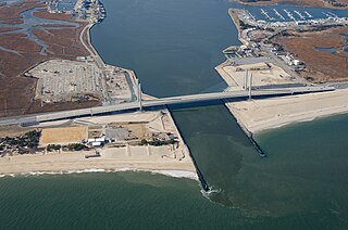
The Indian River Inlet Bridge is a cable-stayed bridge located in Sussex County, Delaware, in the United States. It carries four lanes of Delaware Route 1 over the Indian River Inlet between the Indian River Bay and the Atlantic Ocean. The bridge also carries Delaware Bicycle Route 1 across the inlet. The bridge is within Delaware Seashore State Park between Dewey Beach and Bethany Beach. The Indian River Inlet Bridge is maintained by the Delaware Department of Transportation (DelDOT). The bridge is 2,600 feet (790 m) long and 107.66 feet (32.81 m) wide, with a span of 950 feet (290 m) and overhead clearance of 45 feet (14 m).

Little Mehoopany Creek is a tributary of the Susquehanna River in Wyoming County, Pennsylvania, in the United States. It is approximately 8.4 miles (13.5 km) long and flows through Windham Township and Mehoopany Township. The watershed of the creek has an area of 11.3 square miles (29 km2), most of which is forested land and agricultural land. No stream in the watershed is designated as an impaired waterbody. The main rock formation in the watershed is the Catskill Formation and the main soil association is the Wellsboro-Oquaga-Morris.

References

  1. 1 2 3 4 "Pultruded bridge fulfills early promise". Composite World. Retrieved 18 March 2011.CS1 maint: discouraged parameter (link)
  2. 1 2 3 4 5 "History". Barbados.Org. Retrieved 18 March 2011.CS1 maint: discouraged parameter (link)
  3. 1 2 "Chamberlain Bridge". en.structurae.de. Retrieved 18 March 2011.CS1 maint: discouraged parameter (link)
  4. "ACE Awards – Best of Show". Acmanet.org. Archived from the original on 12 February 2011. Retrieved 18 March 2011.CS1 maint: discouraged parameter (link)
  5. 1 2 "Composolite® Bridge "Draws" Attention in Barbados" (PDF). strongwell.com. Archived from the original (pdf) on 26 March 2010. Retrieved 18 March 2011.CS1 maint: discouraged parameter (link)
  6. 1 2 3 4 5 "Bridge lifting off into 'space age'". archive.nationnews.com. Archived from the original on 21 July 2011. Retrieved 18 March 2011.CS1 maint: discouraged parameter (link)
  7. Melissa Shales (2007). Barbados. New Holland Publishers. pp. 35–. ISBN   978-1-84537-561-4 . Retrieved 25 March 2011.CS1 maint: discouraged parameter (link)
  8. Hunt, George (23 May 1974). Barbados. Batsford. Retrieved 26 March 2011.CS1 maint: discouraged parameter (link)
  9. Sullivan, Lynne M. (1 March 2001). Adventure Guide to Barbados. Hunter Publishing, Inc. pp. 71–2. ISBN   978-1-55650-910-0 . Retrieved 26 March 2011.CS1 maint: discouraged parameter (link)
  10. Warren Alleyne, Historic Bridgetown (1978; St Michael, Barbados Government Information Service, 2003). ISBN   976-8080-47-7
  11. Marley, David (September 2005). Historic cities of the Americas: an illustrated encyclopedia. ABC-CLIO. p. 28. ISBN   978-1-57607-027-7 . Retrieved 26 March 2011.CS1 maint: discouraged parameter (link)
  12. Paterika Hengreaves (September 2007). Poetry for All Seasons: Poems, Forms and Styles. AuthorHouse. pp. 112, 116. ISBN   978-1-4343-0670-8 . Retrieved 25 March 2011.CS1 maint: discouraged parameter (link)
  13. M. Timothy O'Keefe (1 November 2001). Caribbean hiking: a hiking and walking guide to thirty of the most popular islands. Celtcom, Inc. pp. 51–. ISBN   978-0-89732-412-0 . Retrieved 25 March 2011.CS1 maint: discouraged parameter (link)
  14. "Swing Bridge Before Demolition". Barbadostourisminvestment.com. Archived from the original on 22 July 2011. Retrieved 18 March 2011.CS1 maint: discouraged parameter (link)
  15. "Chamberlain Bridge". Nileguide.com. Retrieved 25 March 2011.CS1 maint: discouraged parameter (link)
  16. 1 2 3 "Chamberlain Bridge". Barbadostourisminvestment.com. Archived from the original on 22 July 2011. Retrieved 18 March 2011.CS1 maint: discouraged parameter (link)
  17. 1 2 James Henderson (1 October 2005). Caribbean & the Bahamas. New Holland Publishers. pp. 87–88. ISBN   978-1-86011-212-6 . Retrieved 25 March 2011.CS1 maint: discouraged parameter (link)
  18. "Bridgetown Walking Tour – Tourism Landmarks". Guidetocaribbeanvacations. Retrieved 18 March 2011.CS1 maint: discouraged parameter (link)
  19. 1 2 Harry S. Pariser (May 2000). Explore Barbados. Harry S. Pariser. pp. 119–. ISBN   978-1-893643-51-2 . Retrieved 25 March 2011.CS1 maint: discouraged parameter (link)
  20. 1 2 "Bridge lifting off into 'space age'". National News: barpublish.bits.baseview.com/. 3 February 2006. Archived from the original on 12 August 2011. Retrieved 25 March 2011.CS1 maint: discouraged parameter (link)
  21. "Barbados Careenage Bridges, Bridgetown, Barbados". The Newsletter of the NGCC: Composites in Construction News Issue 02. March 2001. Retrieved 25 March 2011.CS1 maint: discouraged parameter (link)