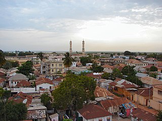
Banjul, officially the City of Banjul, is the capital and fourth largest city of The Gambia. It is the centre of the eponymous administrative division which is home to an estimated 400,000 residents, making it The Gambia's largest and most densely populated metropolitan area. Banjul is on St Mary's Island, where the Gambia River enters the Atlantic Ocean. The population of the city proper is 31,301, with the Greater Banjul Area, which includes the City of Banjul and the Kanifing Municipal Council, at a population of 413,397. The island is connected to the mainland to the west and the rest of Greater Banjul Area via bridges. There are also ferries linking Banjul to the mainland at the other side of the river.
Rankin is a village in Butler Township, Vermilion County, Illinois, United States. It is part of the Danville, Illinois Metropolitan Statistical Area. The population was 561 at the 2010 census.

Yale is a city in Payne County, Oklahoma, United States. The population was 1,059 at the 2020 census, a decline of 13.6 percent from the figure of 1,227 in 2010.

Empire City, or simply Empire, is a town in Stephens County, Oklahoma, United States. The population was 955 at the 2010 census.

Ladysmith is a city and the county seat of Rusk County, Wisconsin, United States. The population was 3,414 at the 2010 census.

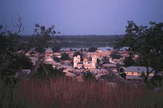
Basse Santa Su, usually known as Basse, is a town in the Gambia, lying on the south bank of the River Gambia. The easternmost major town in the nation, it known for its important market. Basse is the capital of the Upper River Division, which is coterminous with the Basse Local Government Area. As of 2009, the town has an estimated population of 18,414. According to the 2013 census, the Basse LGA has 243,791 residents.
Kanifing is a town in the Gambia, and lies immediately west of the capital city of Banjul.
Kerewan is a town in the Gambia. Located beside the Miniminiyang Bolong, about 60 km from the capital Banjul. It is the seat of the of the Kerewan Local Government Area, located on the north bank of the lower river Gambia.
Bansang is a town in the Central River Division of the Gambia, with a population of 8,843 (2012). Although the official government center of the Division is located in Janjanbureh downstream, Bansang has better access to the more affluent coastal region of the country, and is sometimes considered the unofficial "upcountry" economic capital.
Kuntaur is a town located in central part of the Gambia.
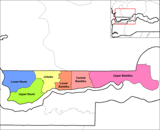
Upper Baddibu was one of the six districts of the North Bank Division of The Gambia. Its main town was Farafenni. The North Bank Division is now the Kerewan Local Government Area, and the former Upper Baddibu District is now divided into an Illiasa District and a Sabach Sanjal District. Its population in the 2003 census, prior to division, was 55,370.

Fulladu East was one of the four districts of the Upper River Division of the Gambia. The Upper River Division is now the Basse Local Government Area, and the former Fulladu East District is now divided into a Basse Fulladu East District, a Jimara District and a Tumana District.
Sandu District is one of the four districts of the Upper River Division of the Republic of the Gambia. It contains the town of Diabugu.
Bantango Koto is a village in the Gambia. It is located in Wuli District in the Upper River Division. As of 2009, it has an estimated population of 327.
Barrow Kunda is a town in the Gambia. Barrow is the name of the Alkalo and Kunda means compound. It is located in Wuli District in the Upper River Division. There is another Barrow Kunda located in Foni Kansala district which is not to be confused with this Barrow Kunda. The Barrow Kunda in Foni Kansala District (Bwiam) has a newly built modern hospital and also a new indoor market which as of mid-2010 is still unopened. The main road S. Bank Road runs through the village. The Alkalo is intending to put the town on the map as a modern town so he is offering land to foreigners who would like to settle in this rural location at a lower cost compared to other more coastal or town based areas. A growing number of foreign nationals have bought and own land in Barrow Kunda. There are also some new developments due to begin construction in 2012, so this village although quiet and rural is set to become modern whilst retaining its calm and peaceful rural location. Those who want rural but modern should consider Barrow Kunda in Foni Kansala District (Bwiam). The Barrow Kunda in Wuli District has as of 2009, an estimated population of 1 730.
Boro Dampha Kunda is a town in the Gambia. It is located in Wuli District in the Upper River Division. As of 2009, it has an estimated population of 353.
Boro Kanda Kassy is a town in the Gambia. It is located in Wuli District in the Upper River Division. As of 2009, it has an estimated population of 1091.
Chamoi is a town in the Gambia. It is located in Fulladu East District in the Upper River Division. As of 2009, it has an estimated population of 197.
New Martinsburg is an unincorporated community in Fayette County, in the U.S. state of Ohio.
Walgrove is an unincorporated community in Kanawha County, in the U.S. state of West Virginia.