Chandrapur Bagicha

Last updated

Chandrapur Bagicha
city
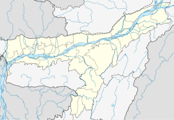
India Assam location map.svg
Red pog.svg
Chandrapur Bagicha
Location in Assam, India
India location map.svg
Red pog.svg
Chandrapur Bagicha
Chandrapur Bagicha (India)
Coordinates: 26°13′45″N91°55′10″E / 26.22917°N 91.91944°E / 26.22917; 91.91944 Coordinates: 26°13′45″N91°55′10″E / 26.22917°N 91.91944°E / 26.22917; 91.91944
CountryFlag of India.svg  India
State Assam
District Kamrup
Population
(2001)
  Total5,230
Languages
  Official Assamese
Time zone UTC+5:30 (IST)
Vehicle registration AS

Chandrapur Bagicha is a census town in Kamrup district in the state of Assam, India.

A census town is a type of town that satisfies certain characteristics, depending on the country in which it is located.

Kamrup district ; also Kamrup rural district is an administrative district in the state of Assam in India formed by bifurcating old Kamrup district into two in the year 2003; other being Kamrup Metropolitan district, named after region it constitute. The district, along with Nalbari and Barpeta together form the Kamrup region, has Kamrupi culture and language.

Assam State in northeast India

Assam is a state in India, situated south of the eastern Himalayas along the Brahmaputra and Barak River valleys. Assam covers an area of 78,438 km2 (30,285 sq mi). The state is bordered by Bhutan and the state of Arunachal Pradesh to the north; Nagaland and Manipur to the east; Meghalaya, Tripura, Mizoram and Bangladesh to the south; and West Bengal to the west via the Siliguri Corridor, a 22 kilometres (14 mi) strip of land that connects the state to the rest of India.

Demographics

As of 2001 India census, [1] Chandrapur Bagicha had a population of 5230. Males constitute 55% of the population and females 45%. Chandrapur Bagicha has an average literacy rate of 73%, higher than the national average of 59.5%; with male literacy of 78% and female literacy of 66%. 11% of the population is under 6 years of age.

Related Research Articles

Birwadi city in Maharashtra, India

Birwadi is a census town in Raigad district in the state of Maharashtra, India.

Chandapur city in Odisha, India

Chandapur is a census town in Nayagarh district in the state of Odisha, India.

Desur town panchayat in Tamil Nadu, India

Desur is a Town panchayat in Tiruvanamalai district in the Indian state of Tamil Nadu.

Ghugus city in Maharashtra, India

Ghugus is a census town in Chandrapur district in the Indian state of Maharashtra.

Kondumal city in Maharashtra, India

Kondumal is a census town in Chandrapur district in the Indian state of Maharashtra.

Mul, India Town in Maharashtra, India

Mul is a town and a municipal council in Chandrapur district in the Indian state of Maharashtra. Pincode of Mul is 441224.

Nakoda, Maharashtra city in Maharashtra, India

Nakoda is a census town in Chandrapur district in the Indian state of Maharashtra.

Peerkankaranai neighbourhood in Chennai, Tamil Nadu, India

Peerkankaranai is a town in Southern part of the metropolitan city of Chennai in the Indian state of Tamil Nadu.

Rafiganj Town in Bihar, India

Rafiganj is a town and a notified area in Aurangabad district in the Indian state of Bihar. It is the district's second-largest town in population after Aurangabad, and also the second-largest town in area. Rafiganj is located 25 km away from the District Administration.

Rajura Town in Maharashtra, India

Rajura is a city and municipal council in the Chandrapur district of the Indian state of Maharashtra.

Ramjibanpur City in West Bengal, India

Ramjibanpur is a city and a municipality in Paschim Medinipur district in the Indian state of West Bengal.

Sasti city in Maharashtra, India

Sasti is a census town in Chandrapur district in the Indian state of Maharashtra.

Thevaram Town Panchayat in Tamil Nadu, India

Thevaram is a Town Panchayat in Theni district in the Indian state of Tamil Nadu. Thevaram is located in Tamil Nadu near on border of Kerala at the Eastern side foot-hill of Western Ghats. The State Highway SH-100 passes through this town.

Vengathur is a census town in Thiruvallur district in the Indian state of Tamil Nadu.

Venkatapur, Bhatkal, Karnataka town in Karnataka, India

Venkatapur is a census town in Bhatkal Taluk in Uttara Kannada district of Karnataka.

Bhadravati, Maharashtra city in Maharashtra, India

Bhadravati is a city and a municipal council in Chandrapur district in the state of Maharashtra, India. It lies 26 km from Chandrapur city. It has an ordnance factory and several open-cast coal mines.

Durgapur, Chandrapur Town in Maharashtra, India

Durgapur is a census town in Chandrapur district in the state of Maharashtra, India.

Shivajinagar, Maharashtra city in Maharashtra, India

Shivajinagar is a city and a majri municipal council in Chandrapur district in the Indian state of Maharashtra.

Kerura City in Karnataka, India

Kerur is a City in Bagalkot district in Karnataka, which located on NH 218. It has an average elevation of 617 meters (2024 feet). Its a birthplace of Jagadish Shettar, a former Chief Minister of Karnataka. Kerur is a Town Panchayat city in district of Bagalkot, Karnataka. The Kerur city is divided into 16 wards for which elections are held every five years. The Kerur Town Panchayat has population of 19,731 of which 9,929 are males while 9,802 are females as per report released by Census India 2011.

Bramhapuri city in Maharashtra, India

Bramhapuri is a city and municipal council in Chandrapur district in the state of Maharashtra, India.

References

  1. "Census of India 2001: Data from the 2001 Census, including cities, villages and towns (Provisional)". Census Commission of India. Archived from the original on 2004-06-16. Retrieved 2008-11-01.