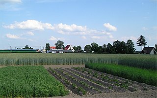
Crop rotation is the practice of growing a series of different types of crops in the same area across a sequence of growing seasons. This practice reduces the reliance of crops on one set of nutrients, pest and weed pressure, along with the probability of developing resistant pests and weeds.

Soil erosion is the denudation or wearing away of the upper layer of soil. It is a form of soil degradation. This natural process is caused by the dynamic activity of erosive agents, that is, water, ice (glaciers), snow, air (wind), plants, and animals. In accordance with these agents, erosion is sometimes divided into water erosion, glacial erosion, snow erosion, wind (aeolian) erosion, zoogenic erosion and anthropogenic erosion such as tillage erosion. Soil erosion may be a slow process that continues relatively unnoticed, or it may occur at an alarming rate causing a serious loss of topsoil. The loss of soil from farmland may be reflected in reduced crop production potential, lower surface water quality and damaged drainage networks. Soil erosion could also cause sinkholes.

Sustainable agriculture is farming in sustainable ways meeting society's present food and textile needs, without compromising the ability for current or future generations to meet their needs. It can be based on an understanding of ecosystem services. There are many methods to increase the sustainability of agriculture. When developing agriculture within sustainable food systems, it is important to develop flexible business processes and farming practices. Agriculture has an enormous environmental footprint, playing a significant role in causing climate change, water scarcity, water pollution, land degradation, deforestation and other processes; it is simultaneously causing environmental changes and being impacted by these changes. Sustainable agriculture consists of environment friendly methods of farming that allow the production of crops or livestock without causing damage to human or natural systems. It involves preventing adverse effects on soil, water, biodiversity, and surrounding or downstream resources, as well as to those working or living on the farm or in neighboring areas. Elements of sustainable agriculture can include permaculture, agroforestry, mixed farming, multiple cropping, and crop rotation.

Subsistence agriculture occurs when farmers grow crops on smallholdings to meet the needs of themselves and their families. Subsistence agriculturalists target farm output for survival and for mostly local requirements. Planting decisions occur principally with an eye toward what the family will need during the coming year, and only secondarily toward market prices. Tony Waters, a professor of sociology, defines "subsistence peasants" as "people who grow what they eat, build their own houses, and live without regularly making purchases in the marketplace".

Dryland farming and dry farming encompass specific agricultural techniques for the non-irrigated cultivation of crops. Dryland farming is associated with drylands, areas characterized by a cool wet season followed by a warm dry season. They are also associated with arid conditions, areas prone to drought and those having scarce water resources.

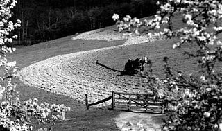
Contour plowing or contour farming is the farming practice of plowing and/or planting across a slope following its elevation contour lines. These contour line furrows create a water break, reducing the formation of rills and gullies during heavy precipitation and allowing more time for the water to settle into the soil. In contour plowing, the ruts made by the plow run perpendicular rather than parallel to the slopes, generally furrows that curve around the land and are level. This method is also known for preventing tillage erosion. Tillage erosion is the soil movement and erosion by tilling a given plot of land. A similar practice is contour bunding where stones are placed around the contours of slopes. Contour plowing has been proven to reduce fertilizer loss, power, time consumption, and wear on machines, as well as to increase crop yields and reduce soil erosion.

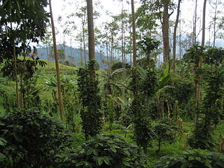
Worldwide more human beings gain their livelihood from agriculture than any other endeavor; the majority are self-employed subsistence farmers living in the tropics. While growing food for local consumption is the core of tropical agriculture, cash crops are also included in the definition.

Environmental issues in Haiti include a historical deforestation problem, overpopulation, a lack of sanitation, natural disasters, and food insecurity. The major reasons for these environmental issues are corruption, human exploitation, and the embezzlement of taxpayers' funds for personal gains. In addition, there is not sufficient protection or management of the country's natural resources. Other environmental issues, such as decreases in precipitation and more severe natural disasters, will likely arise in Haiti as a result of climate change. Experts agree that Haiti needs to adopt new policies to address both the issues that already exist and to prepare for the effects of climate change.
Climate change in Mexico is expected to have widespread impacts: with significant decreases in precipitation and increases in temperatures. This will put pressure on the economy, people and the biodiversity of many parts of the country, which have largely arid or hot climates. Already climate change has impacted agriculture, biodiversity, farmer livelihoods, and migration, as well as water, health, air pollution, traffic disruption from floods, and housing vulnerability to landslides.

There are numerous effects of climate change on agriculture, many of which are making it harder for agricultural activities to provide global food security. Rising temperatures and changing weather patterns often result in lower crop yields due to water scarcity caused by drought, heat waves and flooding. These effects of climate change can also increase the risk of several regions suffering simultaneous crop failures. Currently this risk is regarded as rare but if these simultaneous crop failures did happen they would have significant consequences for the global food supply. Many pests and plant diseases are also expected to either become more prevalent or to spread to new regions. The world's livestock are also expected to be affected by many of the same issues, from greater heat stress to animal feed shortfalls and the spread of parasites and vector-borne diseases.

Climate change in Kansas encompasses the effects of climate change, attributed to man-made increases in atmospheric carbon dioxide, in the U.S. state of Kansas.

Climate change in Kentucky encompasses the effects of climate change, attributed to man-made increases in atmospheric carbon dioxide, in the U.S. state of Kentucky.

Climate change in Louisiana encompasses the effects of climate change, attributed to man-made increases in atmospheric carbon dioxide, in the U.S. state of Louisiana.

Climate change in Nebraska encompasses the effects of climate change, attributed to man-made increases in atmospheric carbon dioxide, in the U.S. state of Nebraska.

Climate change in the United States Virgin Islands encompasses the effects of climate change, attributed to man-made increases in atmospheric carbon dioxide, in the U.S. territory of the United States Virgin Islands. The United States Environmental Protection Agency (EPA) has noted a variety of expected consequences of this phenomenon.

Current agricultural practices of the Andean region of South America typically involve a synthesis of traditional Incan practices and modern techniques to deal with the unique terrain and climatic elements of the area. Millions of farmers in economically impoverished communities make a living producing staple crops such as potato, olluco, and mashua for their own consumption as well as profit in local and urban markets. The Andean region is particularly known for its wide variety of potato species, boasting over about 5,000 varieties identified by the International Potato Center based in Peru. These crops are arranged within the mountains and plateaus of the Andes in four distinct landscape-based units described as Hill, Ox Area, Early Planting, and Valley which overlap one another in a patchwork-styles of plateau surfaces, steep slopes, and wetland patches. Within each of these units, farmers classify soil types as either puna or suni.

Climate change in Tanzania is affecting the natural environment and residents of Tanzania. Temperatures in Tanzania are rising with a higher likelihood of intense rainfall events and of dry spells.
Climate change and agriculture are complexly related processes. In the United States, agriculture is the second largest emitter of greenhouse gases (GHG), behind the energy sector. Direct GHG emissions from the agricultural sector account for 8.4% of total U.S. emissions, but the loss of soil organic carbon through soil erosion indirectly contributes to emissions as well. While agriculture plays a role in propelling climate change, it is also affected by the direct and secondary consequences of climate change. USDA research indicates that these climatic changes will lead to a decline in yield and nutrient density in key crops, as well as decreased livestock productivity. Climate change poses unprecedented challenges to U.S. agriculture due to the sensitivity of agricultural productivity and costs to changing climate conditions. Rural communities dependent on agriculture are particularly vulnerable to climate change threats.

Rainwater harvesting in the Sahel is a combination of "indigenous and innovative" agricultural strategies that "plant the rain" and reduce evaporation, so that crops have access to soil moisture for the longest possible period of time. In the resource-poor drylands of the Sahel region of Africa, irrigation systems and chemical fertilizers are often prohibitively expensive and thus uncommon: so increasing or maintaining crop yields in the face of climate change depends on augmenting the region's extant rainfed agriculture systems to "increase water storage within the soil and replenish soil nutrients." Rainwater harvesting is a form of agricultural water management. Rainwater harvesting is most effective when combined with systems for soil regeneration and organic-matter management.

Malawi is a land-locked country in southeastern Africa situated along the southernmost arm of the East African Rift-Valley System between latitudes 9°22’ and 17°03’ south of the equator, and longitudes 33°40’ and 35°55’ east of the Greenwich meridian. It shares borders with Tanzania in the north and northeast, Mozambique in the southwest, south, and east, and Zambia in the west. Malawi is highly vulnerable to the effects of climate change as the vast majority of Malawians rely on small-scale, rain-fed agriculture, making them highly dependent on weather patterns. Climate change increasingly exacerbates droughts, flooding, and inconsistent rainfall—contributing to food insecurity and threatening to derail progress toward Malawi's goal of self-reliance.


