The River Lea is in South East England. It originates in Bedfordshire, in the Chiltern Hills, and flows southeast through Hertfordshire, along the Essex border and into Greater London, to meet the River Thames at Bow Creek. It is one of the largest rivers in London and the easternmost major tributary of the Thames.
The Hertford Union Canal or Duckett's Cut, just over 1 mile (1.6 km) long, connects the Regent's Canal to the Lee Navigation in the London Borough of Tower Hamlets in East London. It was opened in 1830 but quickly proved to be a commercial failure. It was acquired by the Regents Canal Company in 1857, and became part of the Grand Union Canal in 1927.

The Lee Navigation is a canalised river incorporating the River Lea. It flows from Hertford Castle Weir to the River Thames at Bow Creek; its first lock is Hertford Lock and its last Bow Locks.

Bow Creek is a 2.25-mile (3.6 km) long tidal estuary of the English River Lea and is part of the Bow Back Rivers. Below Bow Locks the creek forms the boundary between the London Boroughs of Newham and Tower Hamlets, in East London.
Bow Back Rivers or Stratford Back Rivers is a complex of waterways between Bow and Stratford in east London, England, which connect the River Lea to the River Thames. Starting in the twelfth century, works were carried out to drain Stratford Marshes and several of the waterways were constructed to power watermills. Bow Creek provided the final outfall to the Thames, and the other channels were called Abbey Creek, Channelsea River, City Mill River, Prescott Channel, Pudding Mill River, Saint Thomas Creek, Three Mills Back River, Three Mills Wall River and Waterworks River.

The Lower Lea Valley is the southern end of the Lea Valley which surrounds the River Lea. It is part of the Thames Gateway redevelopment area and was the location of the 2012 Summer Olympics.

The Euston Arch, built in 1837, was the original entrance to Euston station, facing onto Drummond Street, London. The arch was demolished when the station was rebuilt in the 1960s, but much of the original stone was later located—principally used as fill in the Prescott Channel—and proposals have been formulated to reconstruct it as part of the planned redevelopment of the station, including the station's use as the London terminus of the High Speed 2 line.
The River Moselle, also referred to as Moselle Brook, is in North London and flows through Tottenham towards the Lea Valley. The river was originally a tributary of the River Lea, but it now flows into Pymmes Brook, another Lea tributary.
The Lea Valley, the valley of the River Lea, has been used as a transport corridor, a source of sand and gravel, an industrial area, a water supply for London, and a recreational area. The London 2012 Summer Olympics were based in Stratford, in the Lower Lea Valley. It is important for London's water supply, as the source of the water transported by the New River aqueduct, but also as the location for the Lee Valley Reservoir Chain, stretching from Enfield through Tottenham and Walthamstow.

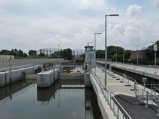
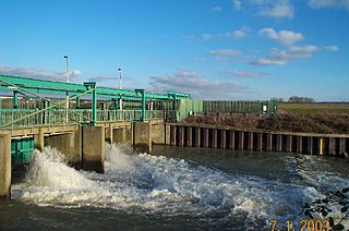
The Prescott Channel was built in 1930–35 as part of a flood relief scheme for the River Lee Navigation in the East End of London, England, and was named after Sir William Prescott, the then chairman of the Lee Conservancy Board. Rubble from the demolished Euston Arch was used in 1962 to improve the channel, which forms part of the Bow Back Rivers.

Cobbins Brook is a minor tributary of the River Lea. It forms to the north of Epping, Essex and flows past Epping Upland, Waltham Abbey until it joins the River Lee Flood Relief Channel below the M25 near Rammey Marsh.
The Lee Flood Relief Channel (FRC) is located in the Lea Valley and flows between Ware, Hertfordshire, and Stratford, east London. Work started on the channel in 1947 following major flooding and it was fully operational by 1976. The channel incorporates existing watercourses, lakes, and new channels. Water from the channel feeds the Lee Valley Reservoir Chain.
Three Mills Lock, also known as the Prescott Lock is a lock on the Prescott Channel on the River Lea in London. The project was led by British Waterways and the lock officially opened on 5 June 2009.

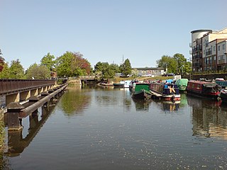
The Hackney Cut is an artificial channel of the Lee Navigation built in England in 1769 by the River Lea Trustees to straighten and improve the Navigation. It begins at the Middlesex Filter Beds Weir, below Lea Bridge, and is situated in the (modern) London Borough of Hackney. When built it contained two pound locks and a half-lock, but was rebuilt to handle larger barges in the 1850s, and now only Old Ford Lock, which is actually a duplicated pair, remains.

Waterworks River is a river, at one time a tidal river, in the London Borough of Newham, one of the Bow Back Rivers that flow into the Bow Creek part of the River Lea, which in turn flows into the River Thames.
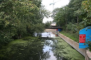
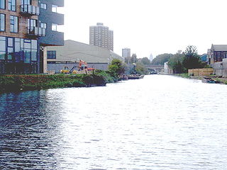
The Old River Lea is the former natural channel of the River Lea below Lea Bridge, in the London Borough of Hackney. The Old River forms a large meander from the Middlesex Filter Beds Weir to rejoin the main channel of the River Lee Navigation below Old Ford Lock, just west of the 2012 Olympic stadium.

Channelsea Island is a small man-made island in the centre of the Channelsea River in East London, near Three Mills Island in the London Borough of Newham.
The Abbey Mill was a medieval tidal watermill in West Ham, London, dating back to at least the 12th century. It was sited on Channelsea Island in the Channelsea River in the London Borough of Newham. It was one of the eight watermills on the River Lea recorded in the Domesday Book.
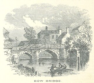
Bow Bridge was a stone bridge built over the River Lea, in what is now London, in the twelfth century. It took its name from the distinctively bow-shaped (curved) arches.


