
Bhola District is an administrative district (zila) in south-central Bangladesh, which includes Bhola Island, the largest island of Bangladesh. It is located in the Barisal Division and has an area of 3737.21 km2. It is bounded by Lakshmipur and Barisal District to the north, the Bay of Bengal to the south, by Lakshmipur and Noakhali districts, the (lower) Meghna river and Shahbazpur Channel to the east, and by Patuakhali District and the Tetulia river to the west. About 400 million cubic feet natural gas has been found at Kachia in Bhola which is being used to run a power station.

Sulthan Bathery, formerly known as Sultan's Battery and Ganapathyvattam is a town and municipality in Wayanad district of Kerala, India, near the borders with Tamil Nadu and Karnataka states. It is The second largest city in Wayanad district, it is the headquarters of Sultan Bathery taluk.

Khagrachari is a district in Chittagong Division, South eastern Bangladesh. It included under Chittagong Hill Tracts region.

Rangpur is a district in Northern Bangladesh. It is a part of the Rangpur Division.
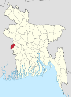
Meherpur is the northwestern district of Khulna Division in southwestern Bangladesh. It is bordered by the Indian state of West Bengal to the west, and by the Bangladeshi districts of Kushtia and Chuadanga to the east. The district has an area of 716.08 square kilometres (276.48 sq mi).

Madhepura district is one of the thirty-eight districts of Bihar state, India, and Madhepura town is the administrative headquarters of this district. Madhepura district is a part of Kosi division.

Jehanabad district is one of the thirty-eight districts of Bihar state, India, and Jehanabad town is the administrative headquarters of this district. Jehanabad district is a part of Magadh Division. This district is 45 km from Patna, the capital of Bihar and 43 km from Gaya.
Rohtas district is one of the thirty-eight districts of Bihar state, India. It came into existence when Shahabad District was bifurcated into Bhojpur & Rohtas in 1972. Administrative headquarter of the district is Sasaram.

Bahawalnagar District, is a district of Punjab province in Pakistan. Before the independence of Pakistan, Bahawalnagar was part of Bahawalpur state governed by the Nawab of Bahawalpur. The city of Bahawalnagar is the capital of the district. Its population according to the 2017 census is 2,982,000 people.
Tinsukia district (pronounced:ˌtɪnˈsʊkiə) is one of the 33 administrative districts in the state of Assam, India. The district headquarters is located at Tinsukia city. The district occupies an area of 3790 km2.

Sadiya is a town in Tinsukia district, Assam. It was the capital of the Chutia Kingdom and after the downfall of the kingdom it became the seat of the Sadiya-khowa-Gohain of the Ahom kingdom. Extensive remains of buildings and fortifications built during the rule of the Chutias near Sadiya still point to the importance of the region in the past. Historically Sadiya referred to the Chutiya kingdom which included at times the districts of Lakhimpur, Dhemaji and Tinsukia. It was the center of development of the Eastern form of Prakrit during both the Chutia and Ahom periods, which later gave rise to the modern form of Assamese. Its stands on a grassy plain, almost surrounded by forested Himalayan mountains, on the right bank of Lohit River which is locally considered the main stream of the Brahmaputra river. Sadiya is famous for a flower named satphul, which is much like Jasmine.

Arambagh is a town and a municipality in Hooghly district in the state of West Bengal, India. It is the headquarters of Arambagh subdivision.

Dhuliyan is a municipality town in Jangipur subdivision of Murshidabad district in the state of West Bengal, India. It is located between the Ganges and the Hooghly canal.
Kandi is a sub-divisional town and a municipality in Murshidabad district in the Indian state of West Bengal. It is the headquarters of the Kandi subdivision and is located on the east bank of Kana Mayurakshi River. It is also known as the rice store of Murshidabad district, owing to its large production of rice. It is situated 30 km away from Berhampore, the district headquarter of Murshidabad and approximately 195 km from Kolkata, the capital of West Bengal.

Debidwar is an upazila of Comilla District in the Division of Comilla, Bangladesh.
Senbag is an upazila of Noakhali District. Senbag is located within an area of 155.83 square kilometres (60.2 sq mi), which is enclosed by Nangalkot upazila, Noakhali Sadar and Companiganj upazilas (south), Daganbhuyiyan upazila, Feni (east), with Begumganj and Laksam upazilas.
Bhairab is a upazila of Kishoreganj District in the Division of Dhaka, Bangladesh. Joanshahi was another name of Bhairab. The city centre of this upazila is Bhairab Bazaar. About 118,992 people live in Bhairab municipality which makes this city the largest in Kishoreganj District and 28th largest city in Bangladesh.
Fulbaria is an upazila of the Mymensingh District in Bangladesh.
Jonai is a sub-division of Dhemaji District in the state of Assam in India.
Kot Radha Kishan is a city and Tehsil headquarters of Kot Radha Kishan Tehsil in Kasur District in the Punjab province of Pakistan. The city is administratively subdivided into four Union councils. It was formerly part of Kasur Tehsil and now it has been rewarded with the status of tehsil of district kasur due to the basic necessities of the current time and the mounting population of the area .It is located at 31°10'21N 74°5'59E with an altitude of 193 metres. Kot Radha Kishan is also called 'City of Containers and Leather'.