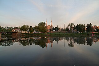
Saint-Tite is a Canadian city located at the foothills of the Laurentians, between Grandes-Piles and Saint-Adelphe, in the Mauricie RCM of Mékinac. A large body of water, Lake Pierre-Paul, bathes the northeastern part of the territory.'

Mékinac is a regional county municipality (RCM) of 5,607 km2 located in the administrative region of Mauricie, along the Saint-Maurice River, which also crosses the RCM from one end to the other, and the Matawin River, a tributary of the Saint-Maurice. Located in the province of Quebec, Canada.

Les Chenaux is a regional county municipality in central Quebec, Canada, in the Mauricie region. The seat is in Saint-Luc-de-Vincennes. It is located adjacent on the east of Trois-Rivières on the Saint Lawrence River. It has a land area of 872.04 square kilometres (336.70 sq mi) and a population of 17,865 inhabitants in the Canada 2011 Census. Its largest community is the parish of Notre-Dame-du-Mont-Carmel.

Sainte-Anne River, Teyaiar River, rivière Sainte-Anne (French), flows from north to south on the north shore in the estuary section of the St. Lawrence River, in Les Chenaux, Portneuf and La Jacques-Cartier RCM, Mauricie and National Capital regions, Quebec, Canada.
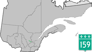
Provincial Highway 159 is a two-lane highway on the north shore of the Saint Lawrence River in Quebec, Canada. Its northern terminus is in Saint-Roch-de-Mékinac at the junction of Route 155, and the southern terminus is at the junction of Route 138 in Sainte-Anne-de-la-Pérade.
Saint-Adelphe is a parish municipality located in the Mékinac Regional County Municipality (RCM), located in Mauricie, Quebec province, Canada.

Saint-Prosper-de-Champlain is a municipality of 516 people in the Les Chenaux Regional County Municipality, in Quebec, Canada. It is the smallest municipality in terms of population in the regional county.
Saint-Stanislas, old name Deux-Rivières (Village), is a municipality part of Les Chenaux Regional County Municipality, in Mauricie, Quebec, Canada.

Sainte-Geneviève-de-Batiscan is a parish municipality in the Mauricie region of the province of Quebec in Canada. This municipality is part of the Les Chenaux Regional County Municipality in Batiscanie and in the administrative region of Mauricie. It is located along the Batiscan River.

Lac-aux-Sables is a parish municipality in the Mékinac Regional County Municipality, in administrative district of the Mauricie region of the province of Quebec in Canada. Its population centres are Lac-aux-Sables and Hervey-Jonction.

Notre-Dame-de-Montauban is a municipality in the Mauricie region in Quebec, Canada. The municipality is on the northern edge of Mékinac Regional County Municipality and the administrative region of Mauricie and includes the population centres of Notre-Dame-des-Anges and Montauban-les-Mines. Both communities are located along route 367 and are about 7 kilometres (4.3 mi) apart.

Batiscan River has its source in the region of Lac Édouard, in the Laurentians Mountains, the Batiscan River flows over a length of 177 km. It receives water from numerous tributaries, including, in its upper reach, the Rivière aux Éclairs and the Jeannotte river. In its downstream part, it waters Saint-Narcisse and Sainte-Geneviève-de-Batiscan before flowing into the St. Lawrence River at Batiscan.

Rivière des Envies is located in Canada, in the province of Quebec, in the Mauricie administrative region, in the Batiscanie. Rivière des Envies course 74 kilometres (46 mi) from the outlet of Lac-de-la-Traverse, located in row St-Joseph, Sainte-Thècle. This lake is fed by the outlet of Lake Aylwin, which in turn is fed by the discharge of Lake Jesuit.
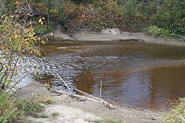
The Pierre-Paul River flows into the Mékinac Regional County Municipality, in the administrative area of the Mauricie, in the province of Quebec, Canada, through these three municipalities of the Batiscanie: Saint-Tite, Sainte-Thècle and Saint-Adelphe.

The Veillet River is located in the municipality of Sainte-Geneviève-de-Batiscan, in the Regional County Municipality of "Les Chenaux", in the administrative region of Mauricie, in the province of Quebec, Canada.

The Seigneurie of Batiscan was located on, and included 1/2 lieue of frontage along, the north shore of the St. Lawrence River in the province of Quebec, Canada. It was 20 lieues deep. Granted in 1639 to the Jesuits, colonization of the manor began in 1666, after an initial allotments were added to the census in 1665.) The northern boundary of the seigneurie was past the source of the Saint-Maurice River. It was the deepest in the seigneurial system of New France. The seigneurie of Batiscan became the most populous governed area of the Three Rivers by the end of the 17th Century.
The Lordship of Sainte-Anne-de-la-Pérade was located on the north shore of St. Lawrence river, between Trois-Rivières and Quebec City in the province of Quebec, Canada. The southern front of the manor was on the edge of St. Lawrence river. The depth of the lordship was heading north, parallel to the Lordship of Batiscan. The northern boundary of the Lordship of Sainte-Anne-de-la-Perade stopped at the north-western boundary of St. Joseph row, in Sainte-Thècle. In comparison, the lordship of Batiscan spanned 20 "lieues", beyond the Saint-Maurice River. The western boundary of the manor cut the Batiscan river at the rapids of Manitou, between Saint-Adelphe and Saint-Stanislas. The estates of the north shore of St. Lawrence river fell within the stately administrative division of Trois-Rivières.

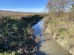
The Rivière des Chutes drains mainly the municipality of Saint-Narcisse, and also Saint-Stanislas, at the end of its course. These municipalities are located in the Les Chenaux Regional County Municipality, in the administrative region of Mauricie, in the province of Quebec, Canada.

The Rivière à la lime flows in the municipality of Sainte-Geneviève-de-Batiscan, in the Les Chenaux Regional County Municipality, in the administrative region of Mauricie, in the province of Quebec, Canada. The "rivière à la lime" drains a watershed of 25.86 km2. This river has a length of 12.14 km and empties into the Batiscan River.
Lake Charest (Mékinac) is located in the area Montauban-les-Mines, in the municipality of Notre-Dame-de-Montauban, in the Mékinac Regional County Municipality (RCM), in the extreme east of the administrative region of Mauricie, in Québec, Canada.