Charlemont Luas stop

Last updated

Charlemont
Luas simple logo.svg
GrandCanal-8-LuasBridge.JPG
Charlemont as seen from the north bank
General information
LocationGrand Parade
Portobello, Dublin
Ireland
Coordinates 53°19′51″N6°15′31″W / 53.33073°N 6.25869°W / 53.33073; -6.25869
Owned by Transport Infrastructure Ireland
Operated by Transdev (as Luas)
Line(s) Green
Platforms2
Construction
Structure typeElevated
AccessibleYes
Other information
Fare zoneCentral/Green 2
Key dates
30 June 2004Stop opened
2018Platforms extended
Location
Open street map central dublin.svg
Red pog.svg
Charlemont
Location within Central Dublin

Charlemont is a stop on the Luas light-rail tram system in Dublin, Ireland. It opened in 2004 on the Green Line from St Stephen's Green to Sandyford. [1] It provides access to parts of the south inner city, including Portobello.

Contents

Location and access

A tram stops at Charlemont stop above the canal Grand Canal 3 und Luas-Haltestelle.jpg
A tram stops at Charlemont stop above the canal

The platforms of Charlemont are located on a steel and concrete beam bridge which crosses the Grand Canal. The waiting shelters are located directly above the canal itself. The advantage of this layout is that the stop can be accessed from either side of the canal: on the south side, a staircase and lift lead from the Grand Parade to the northbound platform. On the north side, staircases lead from each of the platforms to Charlemont Place, but this end does not have step free access. Since the Luas does not have ticket barriers, the bridge can also be used by pedestrians to cross the canal. The bridge has been dedicated to Professor Simon H. Perry, a civil engineer who lead the campaign for a light railway in Dublin. [2] The arrangement of a station on a bridge over water has since been implemented on a much larger scale at London Blackfriars station.[ citation needed ]

One of the platform signs CHARLEMONT LUAS STOP (179850156).jpg
One of the platform signs

To the south of Charlemont, trams continue south on a viaduct built for the Harcourt Street railway line which ran along this alignment from 1854 to 1958. To the north, trams cross Charlemont Place and descend a ramp, continuing through the city centre on the streets.

Services

Trams generally run every 5–10 minutes. Northbound trams either terminate at Parnell or continue to Broombridge. Southbound trams terminate at either Sandyford or continue to Brides Glen.

Bus connections

Charlemont is served by Dublin Bus routes 44, 44B and 61. [3]

Local features

Aside from parts of the south inner city, and the Grand Canal, Cathal Brugha Barracks, Dublin's Eye and Ear Hospital, and the Jewish Museum are located nearby. [4]

In March 2018, the National Transport Authority (Ireland) (NTA) and Transport Infrastructure Ireland (TII) announced the preferred routing and stations for the planned Metrolink project. [5] This plan proposed an underground metro station underneath Charlemont stop. [6] Initially, the route was planned to extend further south to Sandyford, subsuming the Luas Green Line tracks from Charlemont down to its final destination in Sandyford. According to those plans, Luas services on the Green Line would cease between Sandyford and Charlemont, and be replaced by Metro services. [7] In March 2018, public consultations were held and the plan met with considerable opposition regarding the potential closure of the Green Line for an undetermined amount of time and issues regarding pedestrian and cyclist permeability along the line. [8] As a result, revised plans were published in March 2019, where the MetroLink line would be delivered in two phases, meaning the Green Line would not be upgraded during the first phase, [9] but in a second (later) phase. By developing in two phases, the impact could be reduced and more time given to upgrading pedestrian crossings and underpasses. [10] Other commentators have suggested "axing" the proposed Charlemont station altogether. [11]

Related Research Articles

<span class="mw-page-title-main">Luas</span> Light rail system in Dublin, Ireland

Luas is a tram system in Dublin, Ireland. There are two main lines: the Green Line, which began operating on 30 June 2004, and the Red Line which opened on 26 September 2004. Since then, both lines have been extended and split into different branches further out of the city. Further, since 2017 the two lines intersect and connect within Dublin city centre. The system now has 67 stations and 42.5 kilometres (26.4 mi) of revenue track, which in 2018 carried 41.8 million passengers, an increase of 11.2% compared to 2017.

<span class="mw-page-title-main">Ranelagh</span> Residential area of Dublin City

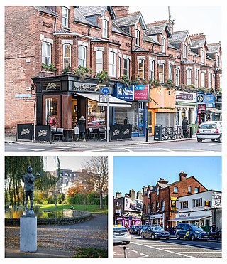
Ranelagh is an affluent residential area and urban village on the Southside of Dublin, Ireland in the postal district of Dublin 6.

<span class="mw-page-title-main">Connolly station</span> Railway station in Dublin, Ireland

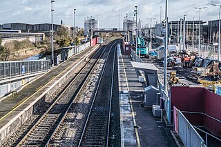
Connolly station or Dublin Connolly is one of the busiest railway stations in Dublin and Ireland, and is a focal point in the Irish route network. On the North side of the River Liffey, it provides InterCity, Enterprise and commuter services to the north, north-west, south-east and south-west. The north–south Dublin Area Rapid Transit (DART) and Luas red line light rail services also pass through the station. The station offices are the headquarters of Irish Rail, Iarnród Éireann. Opened in 1844 as Dublin Station, the ornate facade has a distinctive Italianate tower at its centre.

<span class="mw-page-title-main">Sandyford</span> Suburb of Dublin, in Dún Laoghaire–Rathdown, Ireland

Sandyford is a suburb of Dublin, located in Dún Laoghaire–Rathdown, Ireland.

<span class="mw-page-title-main">Stillorgan</span> Suburb of Dublin, in Dún Laoghaire–Rathdown, Ireland

Stillorgan, formerly a village in its own right, is now a suburban area of Dublin in Ireland. Stillorgan is located in Dún Laoghaire–Rathdown, and contains many housing estates, shops and other facilities, with the old village centre still present. Stillorgan is at least partly contiguous with Kilmacud and neighbours other southside districts such as Mount Merrion, Sandyford, Leopardstown, Dundrum, Blackrock, Goatstown and Foxrock.

<span class="mw-page-title-main">Transport 21</span> Irish road, bus and rail infrastructure plan

Transport 21 was an Irish infrastructure plan, announced in November 2005. Its aims were to greatly expand Ireland's transport network. A cost estimate of €34 billion was attached to the plan at the time.

<span class="mw-page-title-main">Green Line (Luas)</span> Light rail system in Dublin, Ireland

The Green Line is one of the two lines of Dublin's Luas light rail system. The Green Line was formerly entirely in the south side of Dublin city. It mostly follows the route of the old Harcourt Street railway line, which was reserved for possible re-use when it closed in 1958. The Green Line allows for passengers to transfer at O’ Connell GPO and Marlborough to Luas Red Line services and also allows commuters to use Broombridge as an interchange station to reach outer suburbs such as Castleknock and Ongar as well as Iarnrod Éireann services.

MetroLink is a proposed metro line for the city of Dublin. It replaces an earlier proposal called Metro North which was first recommended in the then Irish Government's 2005 Transport 21 transport plan.

<span class="mw-page-title-main">Broombridge railway station</span> Station in Dublin, Ireland

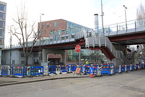
Broombridge is a railway station beside a Luas Tram stop serving Cabra, Dublin 7, Ireland. It lies on the southern bank of the Royal Canal at the western end of what had been Liffey Junction station on the erstwhile Midland Great Western Railway (MGWR). It takes its name from Broome Bridge, which crosses the canal, where William Rowan Hamilton developed the mathematical notion of quaternions. A plaque on the adjacent canal bridge and the name of the Luas Maintenance depot on site, Hamilton Depot, commemorates this.

<span class="mw-page-title-main">Transport in Dublin</span>

This article deals with transport in the Greater Dublin Area centred on the city of Dublin in Ireland.

Balally, County Dublin, Ireland, is a townland and residential area between Dundrum village and the Sandyford Industrial Estate in Sandyford.

<span class="mw-page-title-main">St Stephen's Green station</span> Stop on the Luas (tram) system in Dublin, Ireland

St Stephen's Green is a stop on the Green Line of the Luas (tram) system in Dublin, Ireland. Originally opened in 2004, it was further developed as part of the Luas Cross City project between 2013 and 2017.

<span class="mw-page-title-main">Harcourt Street station</span> Former railway terminus in Dublin, Ireland

Harcourt Street railway station is a former railway terminus in Dublin. The station opened in 1859 and served as the terminus of the line from Dublin to Bray in County Wicklow. It closed in 1958 following the closure of the Harcourt Street line. Since 2004, there has been a Luas tram stop outside the front of the old station.

<span class="mw-page-title-main">Ballyogan Wood Luas stop</span> Tram stop in Dublin, Ireland

Ballyogan Wood is a stop on the green line of the Luas light-rail tram system in Dún Laoghaire–Rathdown, County Dublin, Ireland. The stop provides access to the nearby residential area of Ballyogan, as well as providing access to the nearby Carrickmines Park.

<span class="mw-page-title-main">Carrickmines Luas stop</span> Rail stop in County Dublin, Ireland

Carrickmines is a stop on the Luas light rail tram system in Dún Laoghaire–Rathdown, County Dublin, Ireland, which serves the nearby village of Carrickmines. It opened in 2010 and was built on the site of a disused heavy rail station of the same name.

<span class="mw-page-title-main">Sandyford Luas stop</span> Tram stop south of Dublin

Sandyford is a stop on the Luas light rail tram system in Dún Laoghaire–Rathdown, south of Dublin, Ireland which serves the nearby suburb of Sandyford. It opened in 2004 as the southern terminus of the Green Line, which re-uses the alignment of the Harcourt Street railway line which closed in 1958. Sandyford Luas stop is located on the same site as a station on the old line called Stillorgan.

<span class="mw-page-title-main">Stillorgan Luas stop</span> Tram stop in Dublin, Ireland

Stillorgan is a stop on the Luas Green Line serving Sandyford and Stillorgan in Dún Laoghaire–Rathdown, Ireland. The stop is located between Blackthorn Avenue and the Stillorgan reservoir, at the intersection with St. Raphaela's Road and serves the suburban area of Stillorgan. The stop is 450m up the line from Sandyford Luas stop, which was itself built on the site of an old railway station called Stillorgan.

<span class="mw-page-title-main">Beechwood Luas stop</span> Light rail stop in Dublin, Ireland

Beechwood is a stop on the Luas light rail tram system in Dublin, Ireland which serves the southern parts of Ranelagh and Rathmines. It opened in 2004 as a stop on the Green Line, which re-uses the alignment of the Harcourt Street railway line which closed in 1958. Beechwood Luas stop is located on the same site as a station on the old line called Rathmines and Ranelagh, although it is lower than the original station.

<span class="mw-page-title-main">Milltown Luas stop</span>

Milltown is a stop on the Luas light rail tram system in Dublin, Ireland which serves Milltown, Dublin and southern parts of Dartry, including Trinity Hall. It opened in 2004 as a stop on the Green Line, which re-uses the alignment of the Harcourt Street railway line which closed in 1958. Milltown Luas stop is located a few yards north of the site of the former rail station of the same name.

<span class="mw-page-title-main">Dundrum Luas stop</span> Tram/light rail stop in Dublin, Ireland

Dundrum is a stop on the Luas light rail tram system in Dublin, Ireland which serves the suburb of Dundrum. It opened in 2004 as a stop on the Green Line, which re-uses the alignment of the Harcourt Street railway line which closed in 1958. Dundrum Luas stop is built on the same site as a former heavy rail station of the same name.

References

  1. "Luas Is Launched". RTÉ Archives.
  2. "Luas bridge (Charlemont station), Grand Canal, Dublin 2 | Built Dublin".
  3. "Charlemont". Luas.
  4. "Geohive (Ordnance Survey Ireland mapping". Tailte Eireann (Mapping Division). Retrieved 25 February 2024.
  5. Melia, Paul (22 March 2018). "Revealed: Preferred route for €3bn MetroLink from city centre to Dublin Airport unveiled". Irish Independent . Archived from the original on 27 March 2019. Retrieved 20 April 2018.
  6. "MetroLink". Archived from the original on 31 March 2018. Retrieved 20 April 2018.
  7. "The 'Metro North' is now the MetroLink - here's what it'll look like". TheJournal.ie . Metrolink announcement. 22 March 2018. Archived from the original on 13 April 2018. Retrieved 22 March 2018.
  8. "Opposition to Metrolink plan for south Dublin continues". The Irish Times .
  9. Kilraine, John (26 March 2019). "Luas Green line to remain open under new Metrolink plan". RTÉ. Archived from the original on 26 March 2019.
  10. "Constructability Report - Green Line Closure" (PDF). metrolink.ie. 16 April 2019. Archived (PDF) from the original on 1 October 2020. Retrieved 23 May 2019.
  11. "Proposed Metrolink Charlemont station should be axed, says Fianna Fáil TD". Irish Times. 20 February 2024. Retrieved 20 February 2024.
Preceding station Luas simple logo.svg Luas Following station
Harcourt
towards Parnell or Broombridge
Green Line Ranelagh
Proposed
Preceding station  Dublin Metro  Following station
St Stephen's Green   MetroLink  Terminus