| Charpentier River | |
|---|---|
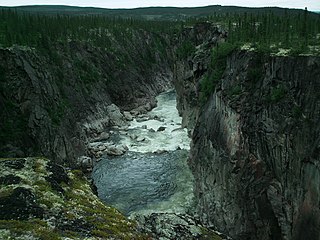
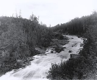
Chutes de Burin | |
| Country | Canada |
| Physical characteristics | |
| Main source | Lac Nedlouc, Nunavik, Quebec 329 m (1,079 ft) |
| River mouth | Lake Minto, Nunavik, Quebec 181 m (594 ft) |
| Length | 125 km (78 mi) |

Charpentier River is a river in northern Quebec (Ungava Peninsula), Canada, that flows from Lac Nedlouc for about 125 km (78 mi) northwest to Lake Minto. A rarely paddled river, it flows through very beautiful wilderness tundra & taiga. It has several picturesque waterfalls, namely Chutes de Burin and Chute Bleu. [1] It is one of the main tributaries of the Leaf River.

Quebec is one of the thirteen provinces and territories of Canada. It is bordered to the west by the province of Ontario and the bodies of water James Bay and Hudson Bay; to the north by Hudson Strait and Ungava Bay; to the east by the Gulf of Saint Lawrence and the province of Newfoundland and Labrador; and to the south by the province of New Brunswick and the U.S. states of Maine, New Hampshire, Vermont, and New York. It also shares maritime borders with Nunavut, Prince Edward Island, and Nova Scotia. Quebec is Canada's largest province by area and its second-largest administrative division; only the territory of Nunavut is larger. It is historically and politically considered to be part of Central Canada.

The Ungava Peninsula of Nunavik, Quebec, Canada, is bounded by Hudson Bay to the west, Hudson Strait to the north, and Ungava Bay to the east.

Canada is a country in the northern part of North America. Its ten provinces and three territories extend from the Atlantic to the Pacific and northward into the Arctic Ocean, covering 9.98 million square kilometres, making it the world's second-largest country by total area. Canada's southern border with the United States is the world's longest bi-national land border. Its capital is Ottawa, and its three largest metropolitan areas are Toronto, Montreal, and Vancouver. As a whole, Canada is sparsely populated, the majority of its land area being dominated by forest and tundra. Consequently, its population is highly urbanized, with over 80 percent of its inhabitants concentrated in large and medium-sized cities, many near the southern border. Canada's climate varies widely across its vast area, ranging from arctic weather in the north, to hot summers in the southern regions, with four distinct seasons.