Related Research Articles

Southeast Alaska, often abbreviated to southeast or southeastern, and sometimes called the Alaska(n) panhandle, is the southeastern portion of the U.S. state of Alaska, bordered to the east and north by the northern half of the Canadian province of British Columbia. The majority of southeast Alaska is situated in Tlingit Aaní, much of which is part of the Tongass National Forest, the United States' largest national forest. In many places, the international border runs along the crest of the Boundary Ranges of the Coast Mountains. The region is noted for its scenery and mild, rainy climate.

Sitka is a unified city-borough in the southeast portion of the U.S. state of Alaska. It was under Russian rule from 1799 to 1867. The city is situated on the west side of Baranof Island and the south half of Chichagof Island in the Alexander Archipelago of the Pacific Ocean. As of the 2020 census, Sitka had a population of 8,458, making it the fifth-most populated city in the state.

Angoon is a city on Admiralty Island in Hoonah-Angoon Census Area, Alaska, United States. At the 2000 census the population was 572; by the 2010 census the population had declined to 459. The name in Tlingit, Aangóon, means roughly "isthmus town."
Port Alexander is a city at the southeastern corner of Baranof Island in Prince of Wales-Hyder Census Area, Alaska, United States. At the 2010 census the population was 52, down from 81 in 2000.

Sheldon Jackson College (SJC) was a small private college located on Baranof Island in Sitka, Alaska, United States. Founded in 1878, it was the oldest institution of higher learning in Alaska and maintained a historic relationship with the Presbyterian Church. The college was named in honor of Rev. Sheldon Jackson, an early missionary and educational leader in Alaska.

Admiralty Island is an island in the Alexander Archipelago in Southeast Alaska, at 57°44′N134°20′W. It is 145 km (90 mi) long and 56 km (35 mi) wide with an area of 4,264.1 km2 (1,646.4 sq mi), making it the seventh-largest island in the United States and the 132nd largest island in the world. It is one of the ABC islands in Alaska. The island is nearly cut in two by the Seymour Canal; to its east is the long, narrow Glass Peninsula. Most of Admiralty Island—955,747 acres (3,868 km2)—is protected as the Admiralty Island National Monument administered by the Tongass National Forest. The Kootznoowoo Wilderness encompasses vast stands of old-growth temperate rainforest. These forests provide some of the best habitat available to species such as brown bears, bald eagles, and Sitka black-tailed deer.

Peril Strait or Shee Káx’ is a strait in the Alexander Archipelago in southeastern Alaska. It is between Chichagof Island to its north and Baranof Island and Catherine Island to its south. The strait is 80 km (50 mi) long and reaches from Salisbury Sound on the west to the Chatham Strait on the east. It is entirely within the limits of the City and Borough of Sitka.
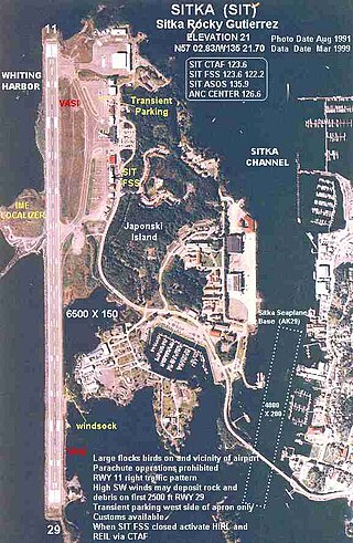
Sitka Rocky Gutierrez Airport is a state-owned, public-use airport located west of the central business district of Sitka, a city and borough in the U.S. state of Alaska.

Baranof Warm Springs is a small, primarily seasonally-occupied community located in the city and borough of Sitka, Alaska, on the eastern side of Baranof Island, from which it likely derives its name, in the Alexander Archipelago. It is occasionally referred to simply as Baranof. Baranof Warm Springs is located at 57°05′22″N134°49′59″W.
Warm Springs Bay is a 2.4 mile-long bay located just outside the small community of Baranof Warm Springs on Baranof Island in the Alexander Archipelago, Alaska. Warm Springs Bay receives the outflow of Baranof Lake and Baranof River. Warm Springs Bay is located at 57°04′49″N134°48′12″W.
Port Walter is located on the southeastern side of Baranof Island in Sitka City and Borough, Alaska. It is made up of two parts: Little Port Walter and Big Port Walter.
Catherine Island is an island in the Alexander Archipelago of southeastern Alaska, United States. It is part of the City and Borough of Sitka and lies just off the northeast corner of Baranof Island, separated from it by Portage Arm. The U.S. Forest Service named Catherine Island in 1935 after Catherine I of Russia. Catherine Island has a land area of 86.936 km2 and no resident population.
The ABC Islands is the colloquial name for the Alaskan islands of Admiralty, Baranof, and Chichagof in the northern part of the Alexander Archipelago, which are all part of the Tongass National Forest. The islands are known for their wilderness and wildlife, including a dense brown bear population.
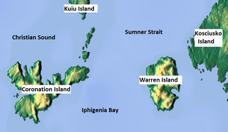
Coronation Island is located in Alaska off the northwest coast of Prince of Wales Island, south of Kuiu Island, and west of Warren Island. High prevailing winds and waves from the open ocean to the west, combined with a steep, rocky coast, result in virtually unaccessible shore due to heavy surf along the windward coastline of the island. The few protected coves and beaches along the leeward shore are guarded by rocky shoals. Thus, the island is difficult to access by any route, and is generally limited to small boat or floatplane during brief lulls in the weather. There are no developed facilities and no groomed trails on the island. Wilderness camping is unrestricted and fishing and hunting are allowed. The nearest full-service community is Craig, Alaska. The island is also home to the Coronation Island Wilderness, which encompasses 19,232 acres (78 km2) and includes the adjacent Spanish Islands. There are several sea caves on the island, and some of these contain fossils.

USC&GS Yukon was a schooner that served as a survey ship from 1878 to 1894 in the United States Coast Survey, which was renamed the United States Coast and Geodetic Survey in 1878. She was the pioneering Coast Survey or Coast and Geodetic Survey ship in many of the waters of the Territory of Alaska, including the Bering Sea and the western Aleutian Islands, and she also operated extensively in California and Washington. She later entered commercial service as Elwood and was wrecked in 1895.
The temperate rainforests of Admiralty Island's Kootznoowoo Wilderness are a unique environment among the 5,700,000 acres (2,300,000 ha) of federally-protected wilderness in Southeast Alaska.

Baranof Island is an island in the northern Alexander Archipelago in the Alaska Panhandle, in Alaska. The name "Baranof" was given to the island in 1805 by Imperial Russian Navy captain U. F. Lisianski in honor of Alexander Andreyevich Baranov. It was called Sheet’-ká X'áat'l by the native Tlingit people. It is the smallest of the ABC islands of Alaska. The indigenous group native to the island, the Tlingit, named the island Shee Atika. Baranof island is home to a diverse ecosystem, which made it a prime location for the fur trading company, the Russian American Company. Russian occupation in Baranof Island impacted not only the indigenous population as well as the ecology of the island, but also led to the United States' current ownership over the land.
Sitka Seaplane Base is a public use seaplane base owned by and located in Sitka, a city and borough in the U.S. state of Alaska. It is included in the National Plan of Integrated Airport Systems for 2011–2015, which categorized it as a general aviation facility. This seaplane base is located near the Sitka Rocky Gutierrez Airport.

Coast Guard Air Station Sitka, Commanded by Captain Vincent J. Jansen, is an Air Station of the United States Coast Guard located in Sitka, Alaska. The station was originally established on Annette Island in March 1944, until relocating to Sitka in 1977. Early aircraft consisted of Grumman G-21's, PBY’s, HU-16’s, HH-52’s, and HH-3 Pelicans. Primary missions performed by the air station are Search and Rescue (SAR), law enforcement, and logistics covering the Southeast part of Alaska. Area of responsibility encompasses approximately 180,000 square miles of water and land extending across Southeast Alaska from Dixon Entrance to Icy Bay (Alaska), and from the Alaskan-Canadian border to the central Gulf of Alaska. This includes 12,000 miles of coastline distinguished by a rugged coast, mountainous terrain, severe weather, and many remote villages.

USRC Wolcott, the second ship of the name, sometimes referred to as USRC Oliver Wolcott, was a revenue cutter in commission in the United States Revenue-Marine from 1873 to 1894 and in the United States Revenue Cutter Service from 1894 to 1897. She served in the waters of the Territory of Alaska during her career. After her revenue cutter service, she operated as a merchant vessel until she was wrecked in 1900.
References
- ↑ "Chatham". Geographic Names Information System . United States Geological Survey, United States Department of the Interior . Retrieved November 21, 2020.
- ↑ "Chatham, Alaska". Google Maps. Retrieved October 24, 2020.
- ↑ "Sitka, Alaska". Google Maps . Retrieved October 24, 2020.
- ↑ "GNIS Detail - Chatham". geonames.usgs.gov. Retrieved December 13, 2020.
57°30′55″N134°56′37″W / 57.51528°N 134.94361°W
| | This article about a location in the City and Borough of Sitka, Alaska is a stub. You can help Wikipedia by expanding it. |