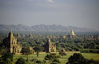
Bagan is an ancient city and a UNESCO World Heritage Site in the Mandalay Region of Myanmar. From the 9th to 13th centuries, the city was the capital of the Pagan Kingdom, the first kingdom that unified the regions that would later constitute Myanmar. During the kingdom's height between the 11th and 13th centuries, more than 10,000 Buddhist temples, pagodas and monasteries were constructed in the Bagan plains alone, of which the remains of over 2200 temples and pagodas survive.
Mogok is a town of around 90,000 people in the Thabeikkyin District of Mandalay Region of Myanmar, located 200 kilometres (120 mi) north of Mandalay and 148 kilometres (92 mi) north-east of Shwebo.

Kyaukse is a town and the capital of Kyaukse District in Mandalay Region, Myanmar. Lying on the Zawgyi River, 25 miles (40 km) south of Mandalay, it is served by the Mandalay-Yangon (Rangoon) railway. The first Myanmar probably settled in the area about 800, and local 12th- and 13th-century inscriptions refer to Kyaukse as “the first home”. Remains of pagodas and old cities are found throughout the area. The Shwethalyaung Pagoda, built by King Anawrahta (1044–77), is located in Kyaukse.

Nat Ma Taung, also known as Mount Victoria, is the highest mountain in the Chin State of western Myanmar.
Letha Taung, also known as the Singu Plateau, is a small volcanic plateau in central Burma (Myanmar).

Payathonzu is a town in the Karen State of south Myanmar, close to the border with Thailand. It is separated from the Thai border township of Nong Lu by the Three Pagodas Pass. It is also the administrative seat of Hpayarthonezu Sub-township in Kyain Seikgyi Township, Kawkareik District of Kayin State in Myanmar.
Singu is a town in the Mandalay Region of central Myanmar. It is the capital of Singu Township. In July 2024, the town fell to the Mandalay People's Defense Force.
Minbya ( is a town in Rakhine State, in the westernmost part of Myanmar. It is located along the Lemro River and foothill of Kyein Range. Kyein Taung Pagoda is one of the prominent Pagoda in Rakhine State. Ramaung Bridge is also well-known. Minbya is convenient in transportation as Sittwe-Yangon high-way road lies near Minbya. Ga Rim Gian is a nice place to visit with the pleasant sights.

Maungdaw Township is a township of Maungdaw District in Rakhine State, Myanmar (Burma). The principal town is Maungdaw.

Nawnghkio Township is a township of Kyaukme District in the Shan State of eastern Myanmar. The principal town and administrative seat is Nawnghkio. The name 'Nawnghkio' was started to call after a camp near a green lake. The lake is located in the west of 'Haw Taw Monastery' of today's Nawnghkio.
Kale Township is a township in Kale District in the Sagaing Division of Burma (Myanmar). The principal town is Kalay.

Kani Township is a township in Yinmabin District, Sagaing Region, Myanmar. The township is subdivided into 188 villages grouped into 45 village tract and 1 town, the principal town of Kani, which contains 3 urban wards.

The Laykyun Sekkya Buddha is, as of 2018, the third-tallest statue in the world at 116 metres (381 ft).

Pinlaung is a town 1,510 metres (4,950 ft) above sea level and seat of Pinlaung Township, in the Pa-O Self-Administered Zone of Shan State of eastern-central Burma. It lies along National Road 54, north-west by road from Loikaw. Running through the city center is a rail line connecting Loikaw to Kalaw, two major tourist towns in the area.
Myinmoletkat Taung is the highest mountain in Tanintharyi Region, Myanmar. It is located on the Bilauktaung, Tenasserim Hills.
Nweyon is a village in Singu Township, Pyinoolwin District, Mandalay Division, Myanmar.
Letkhokpin is a village in Singu Township, Pyinoolwin District, Mandalay Division, Myanmar.
Yage Taung is a peak of the Tenasserim Hills, Burma. This mountain rises within the Tanintharyi National Park which is coterminous with the Kaeng Krachan National Park zone over the border with Thailand.
Baulu Taung is a mountain of the Tenasserim Hills, Burma.


