
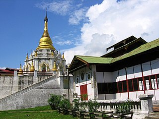
Shan State, also known by the endonyms Shanland, Muang Tai, and Tailong, is a state of Myanmar. Shan State borders China (Yunnan) to the north, Laos to the east, and Thailand to the south, and five administrative divisions of Burma (Myanmar) in the west. The largest of the 14 administrative divisions by land area, Shan State covers 155,800 km2, almost a quarter of the total area of Myanmar. The state gets its name from Burmese name for the Tai peoples: "Shan people". The Tai (Shan) constitute the majority among several ethnic groups that inhabit the area. Shanland is largely rural, with only three cities of significant size: Lashio, Kengtung, and the capital, Taunggyi. Taunggyi is 150.7 km northeast of the nation's capital Naypyitaw.
Bhamo is a city in Kachin State in northern Myanmar, 186 km (116 mi) south of the state capital, (Myitkyina). It is on the Ayeyarwady River. It lies within 65 km (40 mi) of the border with Yunnan Province, China. The population consists of Chinese and Shan, with Kachin peoples in the hills around the town. It is the administrative center of Bhamo District and Bhamo Township.

Mandalay Region is an administrative division of Myanmar. It is located in the center of the country, bordering Sagaing Region and Magway Region to the west, Shan State to the east, and Bago Region and Kayin State to the south. The regional capital is Mandalay. To the south of the region lies the national capital of Naypyidaw. The division consists of eleven districts, which are subdivided into 28 townships and 2,320 wards and village-tracts.

Homalin or Hommalinn is a small town in north-western Burma and capital of the Homalin Township in Hkamti District of the Sagaing Region. The town lies on the Chindwin River and is served by Homalin Airport.

Pyin Oo Lwin District is a district of the Mandalay Region in central Burma. It lies northeast of Mandalay, with the Myitnge River as its southern boundary. To the east it is bordered by Shan State and in part by the Chaung Magyi. It goes north as far as the town of Dakaung where it adjoins Htigyaing Township, Katha District in Sagaing Region. Its western boundary, is for the most part the Irrawaddy, but a very small portion of Thabeikkyin Township is west of the Irrawaddy, near the town of Baw in Sagaing Region. To the southwest it borders Mandalay District.

Madaya is a township of Aungmyethazan District in the Mandalay Region of Myanmar.
Aing Daing is a village island in Madaya Township in Pyin Oo Lwin District in the Mandalay Division of central Myanmar. It lies just outside the north west of Mandalay city and on the Ayeyarwady River.
Dingagyun is a village in Madaya Township in Pyin Oo Lwin District in the Mandalay Division of central Myanmar. It lies north west of Mandalay city and on the Ayeyarwady River.
Thapandaung is a village in Madaya Township in Pyin Oo Lwin District in the Mandalay Division of central Myanmar. It lies just outside the north west of Mandalay city and on the Ayeyarwady River.
Mayogon is a village in Madaya Township in Pyin Oo Lwin District in the Mandalay Division of central Myanmar. It lies just north Mandalay city and several kilometres south-west of Madaya town.
Myinmu is a river town in the south-east of the Sagaing Division in Burma. The town has a rich history linked to World War II during the Burma Campaign against the Japanese, in 1944. It was also under the control of the Portuguese Missionaries in the 19th century. One of the first agricultural cooperatives was established here in 1905.

Nyaungshwe Township is a township of Taunggyi District in Shan State, Myanmar. It is located south of Sakangyi and south-west of Taunggyi. The principal town is Nyaungshwe.

Myitnge River (Burmese: မြစ်ငယ် or Nam Tu, also known as Dokhtawaddy River, is a major tributary of Ayeyarwady River in Myanmar. The name Myitnge in Burmese and Dokhtawaddy in Pali both mean "little river", by contrast with the Ayeyarwady or "big river".
Tagaung is a town in Mandalay Region of Myanmar (Burma). It is situated on the east bank of the Ayeyarwady River, 127 miles north of Mandalay.

Myinmu Township is a township in the southeast of the Sagaing Division in Burma (Myanmar), west of Mandalay. The principal town is Myinmu which lies on the northern bank of the Irrawaddy River. History of Myinmu is closely linked to the World War II against the Japanese Army when British General Sir Douglas Gracey occupied the town after crossing the Irrawaddy River.
Kutkai is a town and seat of Kutkai Township, in the Shan State of eastern-central Burma. It lies along National Highway 3, approximately 24 kilometres to the north of Lashio.
Shwenyaungbin, also Shwe-nyaung-bin or Schwenyaungbiri, is a large village in Mogok Township, Pyin Oo Lwin District, in the Mandalay Region of central Burma. It is located west of Mogok. It lies at a meander on the Kin River and the National Highway 31, which connects it to Kyatpyin and Mogok in the east.
Lamaing is a village in Madaya Township, Pyin Oo Lwin District, in the Mandalay Region of central Burma. It is located southeast of Madaya and north of Mandalay, connected along the National Highway 31. On October 1, 1886 there was a reported small native garrison at Lamaing.
Okpo is a village in Madaya Township, Pyin Oo Lwin District, in the Mandalay Region of central Myanmar. It is located northeast of Madaya and lies on the Mandalay Canal, just south of the Madaya River. In the 16th century, the Gwe Shans built a stockade in the village.
Yenatha or Yentha is a village in Madaya Township, Pyin Oo Lwin District, in the Mandalay Region of central Burma. It is located 7 miles northeast of Madaya, connected by the National Highway 31. The Japanese were reported to have "put up pockets of resistance" at Yenatha during World War II. The Madaya River flows nearby to the south and joins the Irrawaddy River as well as the Yenatha Canal as part of the Mandalay Canal network. The Yenatha Irrigation Scheme has been funded by the Asian Development Bank, who recognizes the importance and potential of agriculture and fisheries in the area. The canal involves a pump irrigation scheme and cost some 9,900,000 kyat to build. A Leprosy hospital lies to the south of Yenatha.


