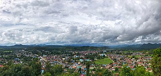
Madaya is a township of Pyin Oo Lwin District in the Mandalay Division of Burma.

Madaya is a town in the Mandalay Region of central Myanmar. It is the seat of Madaya Township. It lies along National Highway 31. Lamaing lies just to the south-east. The Madaya River in the area is connected to the Mandalay Canal, and crosses the township of Madaya diagonally for some 30 miles and joins the Irrawaddy River.

Thapandaung is a village in Madaya Township in Pyin Oo Lwin District in the Mandalay Division of central Myanmar. It lies just outside the north west of Mandalay city and on the Ayeyarwady River.

Shwebaung is a village in Madaya Township in Pyin Oo Lwin District in the Mandalay Division of central Burma. It lies just south east of Thapandaung.

Sinywagale is a village in Madaya Township in Pyin Oo Lwin District in the Mandalay Division of central Myanmar. It lies approximately 15 kilometres north of Mandalay city.

Myitnge is a town in Amarapura Township in the Mandalay Region of central Burma. It is situated between Amarapura and the Myitnge River and lies along National Highway 1 which connects it to the city of Mandalay in the north.

Gyobin is a river town in Homalin Township, Hkamti District, in the Sagaing Region of northwestern Burma. It is located east of Kaukngo. An old frontier outpost was located at Gyobin during the British Burma period.

Yebawmi is a river village in Homalin Township, Hkamti District, in the Sagaing Region of northwestern Burma. It is located near Hwepanan.Yebawmi lies on the banks of the Uyu River and is noted for its salt springs and waistcloth weaving.

Mezali is a village on the Chindwin River in Homalin Township, Hkamti District, in the Sagaing Region of northwestern Burma. The headworks of the Mon Canals were located at Mezali. The irrigation canal passes into the Chindwin River.

Namchaw is a village in Homalin Township, Hkamti District, in the Sagaing Region of northwestern Burma.

Talaunggyaung is a river village in Homalin Township, Hkamti District, in the Sagaing Region of northwestern Burma. It lies near the border with India.

Lamaing is a village in Kale Township, Kale District, in the Sagaing Region of western Burma.

Kutkai is a town and seat of Kutkai Township, in the Shan State of eastern-central Burma. It lies along National Highway 3, approximately 24 kilometres to the north of Lashio.

Sado or Sartoe is a river village on the Myitnge River in Amarapura Township, Mandalay District, in the Mandalay Region of central Burma. It is located just to the southeast of Myitnge.

Yegyibauk is a river village on the Myitnge River in Amarapura Township, Mandalay District, in the Mandalay Region of central Burma. It is located just to the southwest of Myitnge. The village was mentioned in the Agricultural Journal of India by the Indian Council of Agricultural Research in 1914.

Shwenyaungbin, also Shwe-nyaung-bin or Schwenyaungbiri, is a large village in Mogok Township, Pyin Oo Lwin District, in the Mandalay Region of central Burma. It is located west of Mogok. It lies at a meander on the Kin River and the National Highway 31, which connects it to Kyatpyin and Mogok in the east.
National Highway 31 is a major highway of central/northeastern Burma. It starts in Mandalay at the rim of the Mandalay Palace area from National Highway 3 at 21°58′59″N96°5′3″E and ends in Waingmaw/Myitkyina in Kachin State at 25°21′1″N97°26′8″E. The major settlements the road passes through from Mandalay are as follows: Lamaing, Madaya, Yentha, Letkhokpin, Chaunggyi, Shwenyaungbin, Kyatpyin, Mogok, Mong Nit, Pinkyein, Tonkwa, Madangyang, Bhamo, Myothit, Dawhpumyang, Kaxu before finally arriving in Waingmaw.

Okpo is a village in Madaya Township, Pyin Oo Lwin District, in the Mandalay Region of central Myanmar. It is located northeast of Madaya and lies on the Mandalay Canal, just south of the Madaya River. In the 16th century, the Gwe Shans built a stockade in the village.

Yenatha or Yentha is a village in Madaya Township, Pyin Oo Lwin District, in the Mandalay Region of central Burma. It is located 7 miles northeast of Madaya, connected by the National Highway 31. The Japanese were reported to have "put up pockets of resistance" at Yenatha during World War II. The Madaya River flows nearby to the south and joins the Irrawaddy River as well as the Yenatha Canal as part of the Mandalay Canal network. The Yenatha Irrigation Scheme has been funded by the Asian Development Bank, who recognizes the importance and potential of agriculture and fisheries in the area. The canal involves a pump irrigation scheme and cost some 9,900,000 kyat to build. A Leprosy hospital lies to the south of Yenatha.

Namaklwe is a village near the Burma-Thai border in Mong Ton Township of Shan State in eastern Burma, across the border from Nong Uk, Thailand. It lies along National Highway 45 which connects it to Mong Ton in the north, and Chiang Mai may be accessed to the south. It has been a site of conflict when the Burma Frontier Force once gunned down Siamese invaders at Namaklwe.


