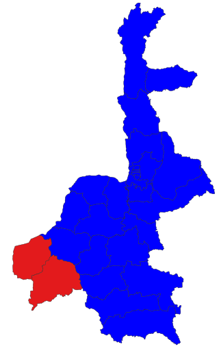
Kyaukpadaung Township is a township of Nyaung-U District (until 2014, part of Myingyan District) in Mandalay Region of Burma (Myanmar). Its administrative seat is the town of Kyaukpadaung. Important towns include Popaywa and Seiktein (Seikhtain).

Kyaukpadaung Township is a township of Nyaung-U District (until 2014, part of Myingyan District) in Mandalay Region of Burma (Myanmar). Its administrative seat is the town of Kyaukpadaung. Important towns include Popaywa and Seiktein (Seikhtain).
Kyaukpadaung Township is the southwesternmost township in Myingyan District and borders the following:
The township includes Mount Popa, the Popa Taungkalat monastery, the Salay ruins from the 12th and 13th centuries and the Kyetmauk Taung Reservoir.
Coordinates: 20°50′N95°8′E / 20.833°N 95.133°E
Capital: Mandalay | ||
| Kyaukse District |   | |
| Mandalay District | ||
| Meiktila District | ||
| Myingyan District | ||
| Nyaung-U District | ||
| Pyinoolwin District | ||
| Yamethin District | ||
| Main cities and towns | ||
| | This Mandalay Region location article is a stub. You can help Wikipedia by expanding it. |

Magway Region is an administrative division in central Myanmar. It is the second largest of Myanmar's seven divisions, with an area of 44,820 km2. Pa Del Dam (ပဒဲဆည်) is one of the dams in Aunglan Township, Magway Division. The capital and second largest city of the Magway Division is Magway. The largest city is Pakokku. The major cities of Magway Division are Magway, Pakokku, Chauk, Aunglan, Yenangyaung, Taungdwingyi, Minbu, Thayet and Gangaw.

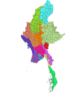
Mandalay Region is an administrative division of Myanmar. It is located in the center of the country, bordering Sagaing Region and Magway Region to the west, Shan State to the east, and Bago Region and Kayin State to the south. The regional capital is Mandalay. To the south of the region lies the national capital of Nay Pyi Taw. The division consists of seven districts, which are subdivided into 28 townships and 2,320 wards and village-tracts.
Meiktila is a city in central Burma on the banks of Meiktila Lake in the Mandalay Region at the junctions of the Bagan-Taunggyi, Yangon-Mandalay and Meiktila-Myingyan highways. Because of its strategic position, Meiktila is home to Myanmar Air Force's central command and Meiktila Air Force Base. The country's main aerospace engineering university, Myanmar Aerospace Engineering University is also located in Meiktila.

Pakokku is a largest city in the Magway Region in Myanmar, also known as Burma. It is situated about 30 km north-east of Bagan on the Irrawaddy River. It is the administration seat of Pakokku Township, Pakokku District and Gangaw District. Pakokku Bridge is part of the India–Myanmar–Thailand Trilateral Highway and is the longest bridge in Myanmar.It is home of the Pakokku airport.
Myingyan is a city and district in the Mandalay Division of central Myanmar, previously, it was a district in the Meiktila Division of Upper Burma. It is currently the capital of Myingyan Township and lies along the National Highway 2. As of 2014, the city had a population of 276,096 and the district had 1,055,957.

Kyaukpadaung is a town in Mandalay Region in Central Myanmar. It lies just south-west of Mount Popa. It is the administrative seat for Kyaukpadaung Township.
Chaung-U is a town in central Myanmar. It is located in Monywa District, Sagaing Division. It is the principal town of Chaung-U township. In the Bagan dynasty, when King Popa Saw Rahan governed the country, it was named "San Tauk Village". It was a large village where different natives of the Union of Myanmar, like Kayin, Shan and Lawah (Wah) natives, lived happily together. Then, King Kyansit founded the city, gathering ten villages together, for example, Ywa Thit and Ywa Ma, naming it Chaung Oo. It is situated 231.46 feet (70.55 m) above sea level at north latitude 22° 45' and east longitude 95° 8' to 95° 25'. The Monywa–Mandalay highway road passes it, so the communication to it is good, quick and easy. The Monywa–Mandalay railway meets that of Chaung-U–Pakokku in the town's station, so it is possible to get there by train. Its official township boundary touches the boundaries of other townships: Myinmu is in the east, Myaung is in the south and south-east, Salingyi is in the west, and Monywa is in the north. The Chindwin River is in the west of the township and the town is six miles away from the river. In Chaung-U there are historical ancient pagodas. Besides, its township has other historical villages, streams, and hills.

Myingyan District is a district of the Mandalay Division in central Burma.

Yamethin Township is a township of Yamethin District in the Mandalay Region of Burma (Myanmar). The administrative seat and principal city is Yamethin, which is also the major rail stop in the township.
Nyaung-U is a district of the Mandalay Division in central Burma.
Taungtha or Thaungtha is a town in the Mandalay Division of central Myanmar. It located south-west of the volcanic cone Mount Taungtha (1788 ft) and above the right (east) bank of the Sindewa (Sintewa) River.There are six quarters in Taungtha township. Taungtha is the administrative seat for Taungtha Township, and is on both the Taunggyi–Myingyan railway and the Meiktila–Myingyan highway. It is also on the Western Trunk Road from Kyaukpadaung to Natogyi.
Chauk Township is a township of Magway District in the Magway Division of Burma (Myanmar). The principal town and administrative seat is Chauk.
Taungdwingyi Township(Burmese: တောင်တွင်းကြီး မြို့နယ်) is a township of Magway District in the Magway Division of Myanmar. The principal town is Taungdwingyi. People have inhabited this area for thousands of years, and one of the earliest civilizations of Myanmar, Beikthano, the ancient Pyu city, is located near the town. The territorial area is planes, and rice, beans, grains, sugarcane, and other plants were grown there.
Shwebo Township is a township of Shwebo District in the Sagaing Region of Burma (Myanmar). It is located on the plains between the Mu River and the Ayeyarwady River. The ancient palace of King Alaungmintaya is being excavated there. Its administrative seat is the city of Shwebo. As of 2014 it has a population of 266,807. 53.7% of its population is male while 46.3% is female.
Townships are the third-level administrative divisions of Myanmar. They are the sub-divisions of the Districts of Myanmar. According to the Myanmar Information Management Unit (MIMU), as of December 2015, there are 330 townships in Myanmar.

Pyinoolwin Township is a township in Pyinoolwin District, Mandalay Region of Burma (Mandalay). The administrative seat is Pyin U Lwin.
Yesagyo Township is a township of Pakokku District in the Magway Region of central Burma (Myanmar). The principal town and administrative seat is Yesagyo.
Seiktein is a town in Mandalay Region in Central Myanmar. It lies just north of Mount Popa, on the Kyaukpadaung–Taungtha road. The town is in two parts, Seiktein North and Seiktein South along the road.
Aingtha is a village in the Mandalay Region of north-west Myanmar. It lies in Kyaukpadaung Township in the Myingyan District. The villages lies east off the bank of the Ayeyarwady River.
Taung U Mandalay Region၊ Kyaukpadaung Township၊ Near Yangon-Mandalay Expressway. Taung U is the middle of Kyaukpadaung and Meiktila.