
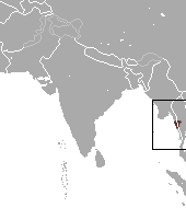
Myanmar is the northwesternmost country of mainland Southeast Asia. It lies along the Indian and Eurasian Plates, to the southeast of the Himalayas. To its west is the Bay of Bengal and to its south is the Andaman Sea. It is strategically located near major Indian Ocean shipping lanes. The neighboring countries are China, India, Bangladesh, Thailand and Laos.

The Malay Peninsula is a peninsula in Southeast Asia. The land mass runs approximately north–south and, at its terminus, is the southernmost point of the Asian mainland. The area contains Peninsular Malaysia, Southern Thailand, and the southernmost tip of Myanmar (Kawthaung), as well as the city state of Singapore, indigenous to or historically inhabited by the Malays, an Austronesian people.

Myanmar is divided into twenty-one administrative subdivisions, which include states, regions, union territory, self-administered zones and self-administered division. Following is the table of government subdivisions and its organizational structure based on different states, regions, zones, division and the union territory:

Dawei is a city in south-eastern Myanmar and is the capital of the Tanintharyi Region, formerly known as the Tenasserim Division, on the northern bank of the Dawei River. The city is about 614.3 km (381.7 mi) southeast of Yangon. Its population is 146,964. Dawei is a port at the head of the Dawei River estuary, 30 km (18.6 mi). from the Andaman Sea. As a result, the city is prone to flooding during the monsoon season. "Dawei" is also the name of one of Myanmar's 135 ethnic minorities.

Western Thailand is a region of Thailand bordering Myanmar on the west, Southern Thailand on the south, and central Thailand on the east.

The Fea's muntjac or Tenasserim muntjac is a rare species of muntjac native to southern Myanmar and Thailand. It is a similar size to the common muntjac . It is diurnal and solitary, inhabiting upland evergreen, mixed or shrub forest with a diet of grasses, low-growing leaves, and tender shoots. The young are usually born in dense vegetation, remaining hidden until able to travel with the mother.

Tanintharyi or Taninthayi is a small town in Taninthayi Township, Myeik District, in the Tanintharyi Region of south-western Myanmar. It is the administrative seat for the township. The town is located on the Great Tenasserim River which eventually enters the sea at Myeik. The town is located at the confluence of this river and a tributary known as the "Little Tenasserim River" which runs south.
The Tenasserim lutung is a species of lutung. It is found in Myanmar and Thailand.

The Burma pipistrelle is a species of vesper bat in the family Vespertilionidae found in Myanmar and Thailand. It is known from Maliwun in Tanintharyi Region (Tenasserim).
The Tenasserim white-bellied rat is a species of rodent in the family Muridae. It is named after the Tenasserim Hills and is found above 1,000 m in forested limestone mountainous areas. Its distribution includes India, Myanmar, Thailand, Cambodia (southern end of the Cardamom Mountains, Laos and Vietnam, and China.
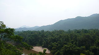
Tenasserim Hills or Tenasserim Range is the geographical name of a roughly 1,700 km long mountain chain, part of the Indo-Malayan mountain system in Southeast Asia.
Saw Zein was king of Martaban from 1323 to 1330. He inherited a newly independent kingdom from his elder brother Saw O but spent much of his reign putting down rebellions. Although he regained the Mon-speaking provinces of Lower Burma, he could not recover the Tenasserim coast from Martaban's former overlord Sukhothai.
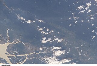
The Great Tenasserim River or the Tanintharyi River is a major river of southeastern Burma. It flows through the Tanintharyi Region, past the town of Tanintharyi, and enters the sea at Myeik (Mergui). The river rises from the Tenasserim Range at an altitude of 2,074 m (6,804 ft), and flows into the Andaman Sea. The region formed by this river is also known as Tenasserim, or Tanintharyi in Burmese. It is in a constricted coastal region in southeastern Myanmar, which borders Thailand on the east and the Andaman Sea on the west.

Tenasserim Island is an island in the Mergui Archipelago, Burma (Myanmar). It is located at the northwestern end of the archipelago 15 km to the south of Kabosa Island. 494 m high, Tenasserim Peak is the highest peak of this steep and thickly wooded island. It is a 10 km long and irregularly shaped island.

The Burmese–Siamese War (1593–1600) was the war fought between the Toungoo Dynasty of Burma and the Ayutthaya Kingdom of Siam. The war was the culmination of Siam's move towards independence following subjugation after the Burmese–Siamese War (1584–1593). The war ended with a victory by Siam, which seized the cities of Tavoy and Tenasserim, and laid siege to two major cities of the Toungoo Dynasty.

The Phuket Range is a subrange of the Tenasserim Hills in the Kra Isthmus, Thailand.

The Dawna Range, also known as Dawna Hills, is a mountain range in eastern Burma and northwestern Thailand. Its northern end is located in Kayah State where it meets the Daen Lao Range, a subrange of the Shan Hills. The range runs southwards along Kayin State as a natural border with Mon State in the west forming parallel ranges to the northern end of the Tenasserim Hills further south and southeast. The Dawna Range extends east of the Salween southwards from the Shan Hills for about 350 km, at the western limit of the Thai highlands. Its southern end reaches the Thai-Myanmar border in the Umphang area, entering Thailand west of Kamphaeng Phet. The Thungyai Naresuan Wildlife Sanctuary is in the Thai side of the range.
Myitta Subtownship is a subtownship of Dawei District in the Taninthayi Division of Myanmar. The main town is Myitta (Matamyu), located on the western side of the Tenasserim Range near the confluence of two tributaries of the Great Tenasserim River.
Sinbyudaing, also known as Sin Byu Daing, is a small village of Dawei District in the Taninthayi Division of Myanmar. It is located on the western side of the Tenasserim Range near the border with Thailand.
