
The Brown Covered Bridge is a wooden covered bridge in Shrewsbury, Vermont. Located in the northwestern part of the town, it carries Upper Cold River Road over the Cold River. It was closed to vehicular traffic in 2011 due to damage from Hurricane Irene and reopened on July 5, 2016. Built in 1880 by noted Vermont bridgewright Nichols M. Powers, it was designated a National Historic Landmark in 2014, cited as one of the finest and least-altered examples of a Town lattice truss covered bridge in the United States.

The Bartonsville Covered Bridge is a wooden covered bridge in the village of Bartonsville, in Rockingham, Vermont, United States. The bridge is a lattice truss style with a 151-foot span, carrying Lower Bartonsville Road over the Williams River. It was built in 2012, replacing a similar bridge built in 1870 by Sanford Granger. The 1870 bridge, which was listed on the National Register of Historic Places, was destroyed in 2011 in flooding caused by Hurricane Irene.

The New Richmond Swing Bridge, also known as the Fifty-Seventh Street Bridge, is a one lane swing bridge in Michigan. Located in Allegan County's Manlius Township, it connected 57th Street with Old Allegan Road over the Kalamazoo River until its closure to vehicular traffic. The name New Richmond comes from a former mining town in the area of the same name. The bridge is one of the oldest - if not the oldest - swing bridges extant in the United States, and is one of the oldest metal truss bridges in the state of Michigan and the state's longest pony truss bridge.

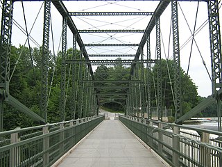
Blackfriars Bridge in London, Ontario, Canada is a wrought iron bowstring arch through truss bridge, crossing the North Thames River. The bridge was constructed in 1875 and carries single-lane vehicles, bicycles and pedestrians from Blackfriars Street to Ridout Street North.

South Royalton is an unincorporated village and census-designated place (CDP) in the town of Royalton, Windsor County, Vermont, United States. With a population at the 2010 census of 694, South Royalton is the largest community in the town. It is home to the Vermont Law School. The central portion of the village is a historic district, listed on the National Register of Historic Places as the South Royalton Historic District. The Joseph Smith Birthplace Memorial is located approximately two miles to the east. South Royalton is the town pictured in the opening credits of the WB television show Gilmore Girls.

The Silk Covered Bridge is a covered bridge, carrying Silk Road across the Walloomsac River between downtown Bennington, Vermont and the village of North Bennington, United States. A Town lattice truss bridge, it was built in 1840, and is one of three covered bridges across the river in fairly close proximity. It was added to the National Register of Historic Places in 1973.

The East Fairfield Covered Bridge is a covered bridge that carries Bridge Street across Black Creek in the East Fairfield village of Fairfield, Vermont. Built about 1865, it is the town's only surviving 19th century covered bridge. It was listed on the National Register of Historic Places in 1974.

The Glen Falls Bridge is a historic bridge that formerly carried Brunswick Avenue over the Moosup River in Plainfield, Connecticut. Built in 1886 by the Berlin Iron Bridge Company, it is one of a shrinking number of surviving 19th-century lenticular truss bridges in the state. The bridge was listed on the National Register of Historic Places in 1999. It has been closed to all traffic for many years.
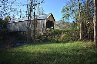
The Flint Covered Bridge is a historic covered bridge carrying Bicknell Hill Road over the First Branch White River in northern Tunbridge, Vermont. Built in 1845, it is the oldest of five 19th-century covered bridges in Tunbridge, representing one of the highest concentrations of covered bridges in the state. It was listed on the National Register of Historic Places on September 10, 1974.

Vermont Route 110 (VT 110) is a state highway in the U.S. state of Vermont. The highway runs 27.136 miles (43.671 km) from VT 14 in Royalton in northern Windsor County north to U.S. Route 302 in the town of Barre in central Washington County. VT 110 follows the valley of the First Branch White River through the Orange County towns of Tunbridge and Chelsea, which contain multiple historic buildings and covered bridges. The highway also follows the Jail Branch River, a tributary of the Winooski River, through Washington and Orange.

The Cascade Bridge is a historic structure located in Burlington, Iowa, United States. In April 1896 the Burlington City Council approved a proposal to have city engineer S.D. Eaton advertise for plans and estimates for a bridge on Main Street that would span Cascade Ravine. The Cascade Lumber Company had petitioned for the bridge. The city contracted with the Cedar Rapids, Iowa firm of Boynton & Warriner to design the structure and the Milwaukee Bridge and Iron Works to erect the span. The city was responsible for building the concrete substructure. The bridge was completed in the fall of 1896, and is composed of four spans. The span length is 160 feet (49 m), and its total length is 464 feet (141 m). The span is a Baltimore deck truss bridge with Pratt deck trusses at both ends. The structure is supported by stone and concrete abutments with concrete pedestals and a single concrete-filled steel cylinder pier. Over the years the original deck has been replaced, and concrete has been applied to the stone abutments. Otherwise the structure has been unaltered. The bridge was listed on the National Register of Historic Places in 1998.

The South Street Bridge is a historic Pratt truss bridge, carrying Vermont Route 31 across the Poultney River just south of the village center of Poultney, Vermont. Built in 1923, it is one of a small number of surviving Pratt through trusses in the state, and one of just three that survives from the period before the state's devastating 1927 floods. It was listed on the National Register of Historic Places in 2009 as Bridge 4.

The Cilley Covered Bridge is a historic 19th-century covered bridge, carrying Howe Lane across the First Branch White River a short way south of the village of Tunbridge, Vermont. Built in 1883, it is a fine example of a king-post truss structure, and is one of the town's five 19th-century covered bridges. It was listed on the National Register of Historic Places in 1974.

The South Royalton Historic District encompasses the central portion of the village of South Royalton, Vermont. Now the town of Royalton's principal commercial center, it developed in the second half of the 19th century around the depot of the Vermont Central Railroad. The district includes fine examples of Greek Revival and Victorian architecture, and is home to the Vermont Law School. It was listed on the National Register of Historic Places in 1976.
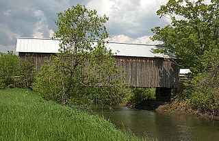
The Howe Covered Bridge is a historic covered bridge carrying Belknap Brook Road across the White River in Tunbridge, Vermont, just east of Vermont Route 110. Built in 1879, it is one of five surviving bridges in the town, one of the highest concentrations of covered bridges in the state. It was listed on the National Register of Historic Places in 1974.

The Larkin Covered Bridge is a historic covered bridge, carrying Larkin Road across the First Branch White River in northern Tunbridge, Vermont. Built in 1902, it is one of the last documented covered bridges to be built in Vermont during the historic period of bridge construction, and is one of five covered bridges in the town. It was listed on the National Register of Historic Places in 1974.

The Mill Covered Bridge is a replica historic covered bridge carrying Spring Road across the First Branch White River in Tunbridge, Vermont. It was built in 2000, nearly replicating a previous structure built on the site in 1883 and lost due to ice damage. It is one of a high concentration of covered bridges in Tunbridge and Chelsea. The 1883 bridge was listed on the National Register of Historic Places in 1974.
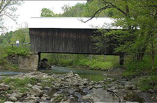
The Moxley Covered Bridge is a historic covered bridge carrying Moxley Road across the First Branch White River in southern Chelsea, Vermont. Built in 1886-87, it is the town's only surviving 19th-century covered bridge. It was listed on the National Register of Historic Places in 1974.
The Douglas & Jarvis Patent Parabolic Truss Iron Bridge is a historic bridge across the Missisquoi River in Highgate, Vermont. Located at the end of Mill Hill Road, it is at 215 feet (66 m) one of the longest bridges of its type in the northeastern United States. It was built in 1887, and was listed on the National Register of Historic Places in 1974.

The Old Boardman Bridge, formerly Boardman Bridge, is a historic lenticular truss bridge, which used to carry Boardman Road across the Housatonic River in New Milford, Connecticut. Built from 1887 to 1888 out of wrought iron, it is one of the state's three surviving examples of this bridge type, and along with Lover's Leap Bridge, one of two in New Milford. It was listed on the National Register of Historic Places in 1976. The bridge was closed to vehicles in 1984 and to pedestrians in 1985; however, the Town of New Milford is seeking to restore it and reopen it to pedestrian traffic.


