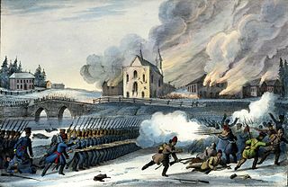
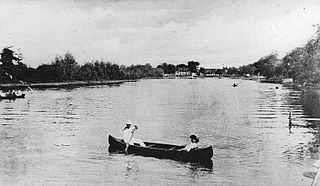
"Stagecoach service on the Chemin Craig established between Quebec and Boston in 1811."
At the turn of the 19th century, in Lower Canada, nearly all of the population lived in communities along the St. Lawrence River. The land between the river and the US border had been surveyed and was ready for settlement. In 1810, Governor James Henry Craig authorized construction of a road to link Quebec and the US city of Boston. He also wanted to promote colonization of the Eastern Townships by anglophones. His ultimate goal was to assimilate the French-Canadian population. The planned route went from Saint-Gilles to Richmond, where an existing road (modern-day Quebec Route 143) continued to the Canadian–American border.
Construction of the road began in August 1810 and took three months. The workforce of 180 soldiers cut trees and built bridges to make the road suitable for traffic. Although the terrain was muddy and damaged in several places, it was suitable enough for a winter stagecoach service, which was established in January 1811 and took passengers from Quebec to Boston in only six days. The service ended at the March thaw and was later abandoned completely because of the difficult travelling conditions, including Lipsey's Hill.
The War of 1812 led to the abandonment of the road. Several bridges were destroyed, and the road became overgrown as nature took its toll. Although some repairs were made, the road was declared unfit for passage in 1829. To relieve that problem, Gosford Road was built to promote settlement in the area.
Craig Road had a mixed success. It opened the territory to new inhabitants, but the results were far from what the planners had desired. Not enough English-speaking settlers arrived, and the goal to assimilate the French Canadians failed. On the contrary, it was the French Canadians who settled the region and became the majority.
In 1983, the Quebec writer Madeleine Ferron published the novel Sur le Chemin Craig, which describes how Irish immigrants settled in the Beauce region of Quebec during the mid-19th century.
The Lower Canada Rebellion, commonly referred to as the Patriots' War in French, is the name given to the armed conflict in 1837–38 between rebels and the colonial government of Lower Canada. Together with the simultaneous rebellion in the neighbouring colony of Upper Canada, it formed the Rebellions of 1837–38.
This section of the Timeline of Quebec history concerns the events in British North America relating to what is the present day province of Quebec, Canada between the time of the Constitutional Act of 1791 and the Act of Union 1840.
Les Appalaches is a regional county municipality (RCM) in the Chaudière-Appalaches region in southeastern Quebec, Canada. It was established in 1982 from parts of the historic counties of Beauce, Frontenac, Mégantic, and Wolfe. The county seat and largest city is Thetford Mines.
Route 138 is a major highway in the Canadian province of Quebec, following the entire north shore of the Saint Lawrence River past Montreal to the temporary eastern terminus in Kegashka on the Gulf of Saint Lawrence. The western terminus is in Elgin, at the border with New York State south-west of Montreal. Part of this highway is known as the Chemin du Roy, or King's Highway, which is one of the oldest highways in Canada.
Autoroute 10 (A-10) is an Autoroute of Quebec in Canada that links greater Montreal to key population centres in Montérégie and Estrie, including Brossard, Saint-Jean-sur-Richelieu, Granby, and Sherbrooke.
Autoroute 35 (A-35) is an Autoroute in the region of Montérégie, Quebec, Canada. Constructed in the 1960s, the A-35 links Saint-Jean-sur-Richelieu with Montreal via the A-10. The A-35 is also the primary route for traffic between Montreal and Boston, although it ends 13.4 km (8.3 mi) short of the U.S. border. South of its current terminus in Saint-Sébastien, the A-35 continues as two-lane Route 133 to the border. An extension of A-35 to meet Interstate 89 at Saint-Armand will complete a nearly 500 km (310 mi) limited-access highway link between Montreal and Boston. It had been scheduled to open in 2017, but construction was on hold and now will be completed up to the Canada-US border by 2023.
Route 243 is a north/south highway on the south shore of the Saint Lawrence River. Its northern terminus is in Saint-Félix-de-Kingsey at the junction of Route 255 and its southern terminus is in the township of Potton where it crosses the Canada–US border at the North Troy–Highwater Border Crossing into Vermont and becomes Vermont Route 243. Route 243 is not a busy highway as it does not go through big towns.
Route 147 (QC 147) is a 41.5-kilometre-long (25.8 mi) north–south highway that runs from the Vermont/United States border in the town of Stanhope. The route begins at the Norton–Stanhope Border Crossing in Stanhope. The route runs north through the Coaticook Regional County Municipality, crossing through Coaticook, Compton and Waterville before reaching a junction with QC 108 and QC 143 in Waterville, which marks the northern terminus of QC 147.
Route 143 is a north/south highway on the south shore of the Saint Lawrence River. Until the mid-1970s when the province decided to renumber all highways other than autoroutes, it was known as Route/Highway 5. Its northern terminus is in Saint-François-du-Lac, at the junction of Route 132, and the southern terminus is in Stanstead, at the border with Vermont where the road continues past the Derby Line–Stanstead Border Crossing as U.S. Route 5 through Derby Line to New Haven, Connecticut.
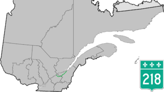
Route 218 is a two-lane east/west highway in Quebec, Canada. Its western terminus is at the junction of Route 132 in Saint-Pierre-les-Becquets and its eastern terminus is in Saint-Michel-de-Bellechasse at the junction of Route 281.
Sainte-Agathe-de-Lotbinière is a municipality in the Municipalité régionale de comté de Lotbinière in Quebec, Canada. Part of the Chaudière-Appalaches region, it had a population of 1168 as of 2016.
The Chemin du Roy is a historic road along the north shore of the St. Lawrence River in Quebec. The road begins in Repentigny and extends almost 280 kilometres (170 mi) eastward towards Quebec City, its eastern terminus. Most of the Chemin du Roy today follows along the present-day Quebec Route 138. The modern expressway that replaces both Route 138 and the Chemin du Roy through most of its course is Quebec Autoroute 40.
The Chateauguay River is a tributary of the South Shore of the St. Lawrence River, flowing in:
The American Lakes to Locks Passage and the corresponding Canadian Route du Richelieu is a scenic byway in northeastern New York in the United States and in southern Quebec in Canada. The byway unifies the interconnected waterway of the upper Hudson River, Champlain Canal, Lake George, and Lake Champlain; this waterway is the core of North America’s first "super-highway" between upstate New York and the Canadian province of Quebec. The initiatives of the Lakes to Locks Passage aim to unify the byway corridor as a single destination. The US portion of the passage is a New York State Scenic Byway, a National Scenic Byway, and an All-American Road. The Canadian portion is a tourist route by the Quebec Ministry of Tourism.
Irlande is a municipality in Les Appalaches Regional County Municipality in the Chaudière-Appalaches region of Quebec, Canada. Its population was 959 as of the Canada 2011 Census.
The Daaquam River is a river primarily flowing in the administrative region of Chaudière-Appalaches, at South of Quebec in Canada and northern Maine, in United States. The river runs from its source, south of Sainte-Justine, northeast across the Canada–United States border to the Northwest Branch of the Saint John River in Maine.
The Tomifobia Nature Trail is a 19 km rail trail in the Eastern Townships region of Quebec. It follows the old route of a Canadian Pacific railway from Ayer's Cliff to Stanstead. In between, it passes through parts of Stanstead-Est, Stanstead Township, and Ogden.
The Franco-Americans, or French Americans, are a group of people of French, French-Canadian, and Acadian descent living in the United States. Today there are 11.8 million Franco-Americans in the US and 1.6 million Franco-Americans who speak French at home. There are also an additional 450,000 Americans who speak a French-based creole language, for example, Haitian Creole. Even though Franco-Americans are a substantial portion of the US population, they are generally less visible than other sizable ethnic groups. This is partly because of geographical dispersal, and partly because a large proportion of Franco-Americans have acculturated or assimilated.
The ZEC Louise-Gosford is a "zone d'exploitation contrôlée" (ZEC), located in two municipalities: Saint-Augustin-de-Woburn for the south part of the zec and Frontenac for the north sector of the zec. The zec is located in Le Granit Regional County Municipality, in Eastern townships, in Quebec, in Canada.
The Gobeil River is a tributary of the Big Black River, flowing through:
This page is based on this Wikipedia article Text is available under the CC BY-SA 4.0 license; additional terms may apply. Images, videos and audio are available under their respective licenses.