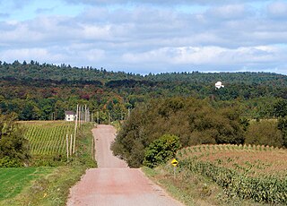
Saint-Louis-du-Ha! Ha! is a parish municipality in the Témiscouata Regional County Municipality of the Bas-Saint-Laurent region of Quebec. The population is 1,318. Its economy is mainly agricultural. It is located southeast of Rivière-du-Loup and west of Cabano along the Trans-Canada Highway, about halfway to Edmundston in New Brunswick.

Maskinongé is a regional county municipality in the Mauricie region of Quebec, Canada. The seat is Louiseville. It is located adjacent on the west of Trois-Rivières on the Saint Lawrence River.
Mékinac is a regional county municipality (MRC) in the administrative region of Mauricie, in the province of Quebec, Canada. Its seat is Saint-Tite. It is composed of 10 municipalities and 4 unorganized territories.

Minganie is a regional county municipality in the Côte-Nord region of Quebec, Canada. It includes Anticosti Island. Its seat is Havre-Saint-Pierre.

Sept-Rivières is a regional county municipality of Quebec, Canada, in the Côte-Nord region. Its county seat is Sept-Îles.
Vaudreuil-Soulanges is a regional county municipality in Quebec, Canada. It is located on a triangular peninsula in the western Montérégie region of Quebec, formed by the confluence of the Ottawa River to the north, and the St. Lawrence River to the south. Ontario is located west of here.

Les Chenaux is a regional county municipality in central Quebec, Canada, in the Mauricie region. The seat is in Saint-Luc-de-Vincennes. It is located adjacent on the east of Trois-Rivières on the Saint Lawrence River. It has a land area of 872.04 square kilometres (336.70 sq mi) and a population of 17,865 inhabitants in the Canada 2011 Census. Its largest community is the parish of Notre-Dame-du-Mont-Carmel.

L'Islet is a municipality within L'Islet Regional County Municipality in the Chaudière-Appalaches region of Quebec, Canada.
Rivière-Ouelle is a town located in the Kamouraska Regional County Municipality within the Bas-Saint-Laurent region of Quebec. It is located on the Saint Lawrence River; the Ouelle River flows through the town. It was part of the seignory of La Bouteillerie, once owned by Charles Deschamps de Boishébert et de Raffetot. Jean-Charles Chapais, a Father of Canadian Confederation, was born here.
Brownsburg-Chatham is a municipality in the Laurentides region of Quebec, Canada, part of the Argenteuil Regional County Municipality. It is located along the Ottawa River, just west of Lachute, and includes the communities of Brownsburg, Cushing, Dalesville, Greece's Point, Pine Hill, and Saint-Philippe. Economic activities include agriculture, tourism and the manufacture of explosives.

Trois-Rives is a municipality with an area of 675 square kilometres (261 sq mi) located in Mékinac Regional County Municipality, in the Mid-Mauricie, province of Quebec, Canada.

Saint-André-de-Kamouraska is a municipality in the Canadian province of Quebec, located in the Kamouraska Regional County Municipality. Before 2020 it was only known as Saint-André.

Dundee is a township municipality in Le Haut-Saint-Laurent Regional County Municipality in the Montérégie administrative region of Quebec, Canada. At the Canada 2011 Census, the population was 408. It is primarily an agricultural area consisting of dairy and grain farms.
Gore is a township municipality in the Canadian province of Quebec, located within the Argenteuil Regional County Municipality. Its main community is Lakefield.

Rivière-Bleue is a municipality in Quebec with more or less 1500 inhabitants. The municipality is located in the Bas-Saint-Laurent region on the border of the province of New-Brunswick and Canada–United States border with Maine.
Saint-Marcel is a municipality in Quebec located in the MRC de L'Islet in the Chaudière-Appalaches.
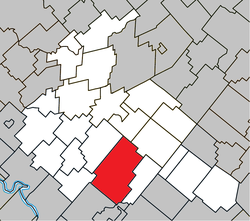
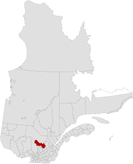
Saint-Rémi-de-Tingwick is a municipality located in the Centre-du-Québec region of Quebec, Canada.

The Rivière des Pins is a tributary of the Nicolet River which flows on the south bank of the Saint Lawrence River. The Pins River flows through the municipalities of Saint-Rémi-de-Tingwick, Tingwick, Warwick and Saint-Albert-de-Warwick, in the regional county municipality (MRC) of Arthabaska, in the region of Centre-du-Québec, in Quebec, in Canada.

The rivière des Rosiers is a tributary of the Nicolet River which flows on the south shore of the St. Lawrence River. The Rosiers River flows through the municipalities of Tingwick, Kingsey Falls, Warwick, Sainte-Élizabeth-de-Warwick and Saint-Albert-de-Warwick, in the Arthabaska Regional County Municipality (MRC), in the Centre-du-Québec region, in Quebec, in Canada.
The Petite rivière à Monfette is a tributary on the north bank of the Nicolet Southwest River (Les Trois Lacs. It flows into the municipality of Saint-Rémi-de-Tingwick, in the Arthabaska Regional County Municipality, in the administrative region of Centre-du-Québec, in Quebec, in Canada.