
Normandy is a geographical and cultural region in northwestern Europe, roughly coextensive with the historical Duchy of Normandy.

Brittany is a peninsula, historical country and cultural area in the north-west of modern France, covering the western part of what was known as Armorica in Roman Gaul. It became an independent kingdom and then a duchy before being united with the Kingdom of France in 1532 as a province governed as a separate nation under the crown. Brittany is the traditional homeland of the Breton people and is one of the six Celtic nations, retaining a distinct cultural identity that reflects its history.
Manche is a coastal French département in Normandy on the English Channel, which is known as La Manche, literally "the sleeve", in French. Manche is bordered by Ille-et-Vilaine and Mayenne to the south, Orne and Calvados to the east, the English Channel to the west and north and by sharing maritime borders with the Crown Dependencies of Bailiwick of Jersey and Bailiwick of Guernsey of the United Kingdom to the west. It had a population of 495,045 in 2019.

Maine is one of the traditional provinces of France. It corresponds to the former County of Maine, whose capital was also the city of Le Mans. The area, now divided into the departments of Sarthe and Mayenne, has about 857,000 inhabitants.

Laval is a town in western France, about 300 km (190 mi) west-southwest of Paris, and the capital of the Mayenne department.

The Chouannerie was a royalist uprising or counter-revolution in twelve of the western départements of France, particularly in the provinces of Brittany and Maine, against the First Republic during the French Revolution. It played out in three phases and lasted from spring 1794 to 1800. The revolt was comparable to the War in the Vendée, which took place in the Vendée region.

Laval Agglomération is the communauté d'agglomération, an intercommunal structure, centred on the city of Laval. It is located in the Mayenne department, in the Pays de la Loire region, western France. It was created in 2001 as the Communauté d'agglomération de Laval. It was merged with the former communauté de communes du Pays de Loiron to form the communauté d'agglomération Laval Agglomération on 1 January 2019. Its area is 686.1 km2. Its population was 113,854 in 2016, of which 49,573 in Laval proper.

The arrondissement of Laval is an arrondissement of France in the Mayenne department in the Pays de la Loire region. It has 34 communes. Its population is 114,674 (2021), and its area is 686.1 km2 (264.9 sq mi).
Liberty Road is the commemorative way marking the route of the Allied forces from D-Day in June 1944. It starts in Sainte-Mère-Eglise, in the Manche département in Normandy, France, travels across Northern France to Metz and then northwards to end in Bastogne in Belgium, on the border of Luxembourg. At each of the 1,146 kilometres, there is a stone marker or 'Borne'. The first lies outside the town hall in Sainte-Mère-Église.

Ledringhem is a commune in the Nord department in northern France.

The Chemin de fer touristique du Cotentin is a 1,435 mmstandard gauge heritage railway and voluntary association in Normandy, France. The railway runs between Barneville-Carteret and Portbail on part of the former railway line linking Carentan to Barneville-Carteret in Cotentin.
The Route nationale 12, or RN12, is a trunk road (nationale) in France connecting Paris with Brittany. The road forms part of European route E50. It is approximately 570 km (350 mi) long.
The Regordane Way is the southernmost section of the historical route that links Paris to Lower Languedoc and the Camargue. It runs from Le Puy-en-Velay, south west of St Etienne to Saint-Gilles-du-Gard to the south west of Nîmes, a distance of 211 kilometres or 140 miles.

The Battle of La Brossinière or Battle of la Gravelle was a battle of the Hundred Years' War on 26 September 1423. It occurred at La Brossinière, between the forces of England and France, shortly after hostilities had resumed, following the battle of Agincourt (1415).
Avranchin is an area in Normandy, France corresponding to the territory of the Abrincatui, a tribe of Celts from whom the city of Avranches, the main town of the Avranchin, takes its name.
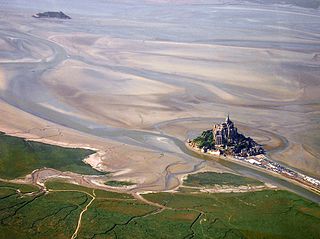
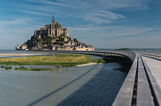
The Mont-Saint-Michel Bay is located between Brittany and the Normandy peninsula of Cotentin. The bay was listed as a UNESCO world heritage site in 1979 for its aesthetic quality and its importance to the Christian tradition. Due to the significant tidal movements in this region a large part of the bay is uncovered at low tide. There are two granitic islands in the bay: Tombelaine and the Mont-Saint-Michel. Many birds and harbor seals live in this area.

Jean-Loup Trassard is a French writer and photographer.
The canton of Loiron-Ruillé is an administrative division of the Mayenne department, northwestern France. Its borders were not modified at the French canton reorganisation which came into effect in March 2015. Its seat is in Loiron-Ruillé.

The Jublains archeological site is a cluster of ruins, mostly dating back to Ancient Rome, in the current French commune of Jublains in the département of Mayenne in the Pays de la Loire.

At the end of the 19th and the beginning of the 20th century, the Southwest Line was designed to connect the port of Le Havre to the left bank of the Seine, and then to the west and southwest of France, by crossing the river near the estuary.