
Erode District is one of the 38 districts in the state of Tamil Nadu in India. It was the largest district by area in the state before the formation of Tirupur District in 2009. The headquarters of the district is Erode. It is divided into two revenue divisions, Erode and Gobichettipalayam, and is further subdivided into 10 taluks. Erode District was a part of Coimbatore District before its division into two on 17 September 1979. It covers an area of 5,722 square kilometres (2,209 sq mi), and as of 2011, had a population of 2,251,744.
Dharmapuri is a city in the north western part of Tamil Nadu, India. It serves as the administrative headquarters of Dharmapuri district which is the first district created in Tamil Nadu after the independence of India by splitting it from then Salem district on 2 October 1965. The city is located at 50 km from Krishnagiri, 69 km from Salem, 90 km from Hosur, 117 km from Thiruvannamalai, 126 km from Bangalore and Erode, 181 km from Tiruppur, 200 km from Coimbatore and Tiruchirappalli, 300 km from Madurai and the state capital Chennai. It is located between latitudes N 11 47’ and 12 33’ and longitudes E 77 02’ and 78 40’. It is one of the leading major cultivator and producer of mango in the state along with Krishnagiri often referred as Mango Capital of India.
Velagoundampatti is a place in Tamil Nadu, India. It is located on the state highway connecting the district headquarters, Namakkal with the other major town of this area, Thiruchengode. It is located along the State Highways SH-94 stretch, connecting Namakkal with Erode, Tirupur, Coimbatore. Velagoundampatti have two panjayath Aniyar and Marukalampatti.

Aravakurichi is a panchayat town and a Taluk headquarters in Karur district in the state of Tamil Nadu, India. Aravakurichi is well known in Tamil Nadu as a major market for Moringa oleifera vegetable. Aravakurichi is headquaters of Aravakurichi taluk which consists of 40 revenue Villages.
Chennimalai is a town in Erode district, Tamil Nadu, India. It is popularly known as the 'Handloom Town'.

Dharapuram officially Tharaapuram is a town situated along the banks of Amaravati River in Tiruppur district in the Indian state of Tamil Nadu. Dharapuram is one of the oldest towns in Tamil Nadu and was the capital of Kongu Nadu under the Cheras, Western Ganga Dynasty and later Kongu Cholas, at which time it was known as Vanchipuri. Amaravathi River flows through the town. As of 2011, the town had a population of 67,007. Dharapuram Municipality is promoted 1st grade municipality on 6 May 1983. Dharapuram was Part of Coimbatore district in the beginning and later it moves to Erode district up to 2009.

Jayankondam is a Second Grade Municipality in Ariyalur district of Tamil Nadu in India. As of 2011, the town had a population of 33,945.
Kangeyam is a town and municipality in Kangeyam Taluk of Tiruppur district in the Indian state of Tamil Nadu. It is situated on National Highway 81. Kangeyam is an economic center in Tamil Nadu. The main commercial interests of the municipality are rice hulling, coconut oil extraction, ghee production, and groundnut cultivation. The town is located 28 km from the district headquarters at Tiruppur, 45 km from the city of Erode, 70 km from the industrial town of Coimbatore, 55 km from the city of Karur, 140 km from the Ancient city of Trichy and 441 km from the state capital Chennai.
Karumathampatti is a Municipality in the Coimbatore district in the state of Tamil Nadu, India. It is one of the most developing suburb in Coimbatore about 25 km away from the city centre. It is situated in between NH544 which connects the city of Coimbatore with Salem – Erode – Tirupur and also in between the State Highway 165 connects Annur – Kamanaikenpalayam. Nearby places are Somanur-3 km, Avinashi-10 km, Tirupur-20 km, Sulur-15 km, Annur-16 km. Coimbatore -27,Mettupalayam-38,Palladam-19. Karumathampatti lies near the junction of two major roads, NH544(Coimbatore – Salem) and Karumathampatti – Annur road.

Udumalai, also known as Udumalaipettai and Udumalpet, is a town in Tiruppur district in the Indian state of Tamil Nadu. Udumalaipettai is located 535 km south west from the state capital, Chennai and 72 km away from Coimbatore, the second largest city in the state.
Vellakovil is a municipal town in Kangeyam taluk of Tirupur District, in the Indian state of Tamil Nadu. It is located on National Highway 81 between Trichy and Coimbatore. The town is spread in an area of 64.75 km2. As of 2011, the town had a population of 40,359. Kannapuram village located near to this town is famous for Kangeyam breed cattle market that happens on every year during Mariyamman temple festival in the month of April. It is an industrialized town with traditional agriculture being the occupation for most of the people. It holds lot of Power looms weaving bedsheets, floor mats and cotton materials being exported to foreign countries via exporters present in Karur.

Vijayamangalam is a census town in Erode district in the Indian state of Tamil Nadu. It is located on National Highway 47 (NH-47) between Perundurai and Perumanallur.

Avinashi is a Special Grade Town Panchayat in Tiruppur district in the Indian state of Tamil Nadu. Avinashi is one among the nine taluks of the district. It is one of the popular pilgrim destinations in Western Tamilnadu region. It is located on National Highway NH544, which bypasses the town. The history of the town is centered around the Avinasilingeswarar temple. The town was previously a part of the Coimbatore district until Tirupur was carved out as a separate district from the erstwhile districts of Coimbatore and Erode. It is a stopping place for vehicles travelling from the western part of Tamil Nadu to Chennai and Cochin.
Iduvai is a village near Tiruppur in the south Indian state of Tamil Nadu. Iduvai is about 48 kilometres (30 mi) from Coimbatore, 9 km (6 mi) from Tirupur and 12 km (7 mi) from Palladam. It is located on Tirupur–Palladam State Highway 19.
Perumanallur is a textile Industrial city situated near Tirupur, Tamil Nadu, India. Coimbatore city on the National Highway which now bypasses outside the town. It is a cross junction in NH-47 connecting Cochin/Coimbatore with Erode/Salem and Tirupur with Gobichettipalayam.
Erode city being the headquarters of Erode district, in Tamil Nadu, India, has an extensive road and rail transport network in all radial directions, as it lies landlocked.

National Highway 79 is a National Highway in India entirely within the state of Tamil Nadu. It runs between Ulundurpettai and Salem in the Indian state of Tamil Nadu for a total of 134 km (83 mi). It connects with NH 44 and NH 544 at Salem. NH 79 connects NH 68 and SH 69 at Ulundurpettai and SH 6 at kallakurichi. It was upgraded to a dual carriageway road in two phases on a Build-operate-transfer basis by Reliance Infrastructure and Maytas.
Tiruvannamalai is predominantly connected by road to other major cities in the state including Chennai, Bengaluru, Vellore, Arani, Trichy, Tiruppur, Salem, Thanjavur, Coimbatore, Shimoga and Kanchipuram. And also other state major cities such as Hyderabad, Tirupati, Puducherry and Mangaluru. Tiruvannamalai serves as one of the important Road junction of Tamil Nadu and north roadways Zone. The nearest domestic airport is Vellore, which has a no daily chartered flights. The nearest international airports are Chennai and Tiruchirappalli.
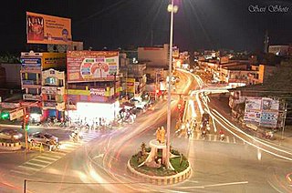
Tiruppur or Tirupur is a city in the Indian state of Tamil Nadu. Tiruppur is the administrative headquarters of Tiruppur district and the fifth largest city as well as an urban agglomeration in Tamil Nadu. Located on the banks of Noyyal River, it has been ruled at different times, by the Early Pandyas, Medieval Cholas, Later Cholas, Mysore Kingdom and the British. It is about 450 kilometres (280 mi) southwest of the state capital Chennai about 50 kilometres (31 mi) east of Coimbatore 50 kilometres (31 mi) south of Erode and 50 kilometres (31 mi) north of Dharapuram.
Karanampettai is a town located in the Tiruppur district of Tamil Nadu, India. It is a suburb of Coimbatore.It lies on the National Highway 81. It is a part of Palladam taluk and Palladam which comes under the Coimbatore Parliament Constituency.
