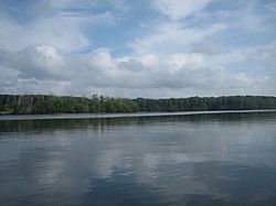
Chepo River

Last updated
Chepo River
Rio Bayano La Mochila.jpg
Panama relief location map.jpg
Red pog.svg
Location of mouth
Location
Country Panama
Physical characteristics
Mouth  
  coordinates
8°59′53″N79°06′49″W / 8.9980°N 79.1136°W / 8.9980; -79.1136

The Chepo River is a river of Panama in the Chepo District of Panama Province. It drains into the Pacific Ocean.

Contents

Course

The uppermost reaches of the Chepo is alternately called the Bayano River after the construction of the Bayano Dam that resulted in the 350-square-kilometre (140 sq mi) lake reservoir. [1] The headwaters of the Chepo encompass watercourses running south from the San Blas Mountains near the Caribbean along with other rivers draining parts of the Majé and Darien Mountains. [2]

The Mamoni River is a major tributary farther down stream.

Measuring 206 kilometres (128 mi) in length, the Chepo-Bayano is the third longest river of Panama. [3]

Coquira, in the lower reaches, is the main riverine port.

See also

Related Research Articles

<span class="mw-page-title-main">Geography of Panama</span>

Panama is a country located in Central America, bordering both the Caribbean Sea and the Pacific Ocean, between Colombia and Costa Rica. Panama is located on the narrow and low Isthmus of Panama.

<span class="mw-page-title-main">Pan-American Highway</span> Network of roads in the Americas

The Pan-American Highway is a network of roads stretching across the Americas and measuring about 30,000 kilometres (19,000 mi) in total length. Except for a break of approximately 106 km (66 mi) across the border between northwest Colombia and southeast Panama called the Darién Gap, the roads link almost all of the Pacific coastal countries of the Americas in a connected highway system. According to Guinness World Records, the Pan-American Highway is the world's longest "motorable road". It is only possible to cross by land between South America and Central America—the last town in Colombia to the first outpost in Panama—by a difficult and dangerous hike of at least four days through the Darién Gap, one of the rainiest areas of the planet.

<span class="mw-page-title-main">Pan-American Highway (North America)</span>

The Pan-American Highway route in North America is the portion of a network of roads nearly 48,000 kilometres (30,000 mi) in length that travels through the mainland nations of the Americas. No definitive length of the Pan American Highway exists because the Canadian government has never officially defined any specific route as being part of the Pan-American Highway, while in the United States, the Federal Highway Administration (FHWA) has designated the entire Interstate Highway System part of the Pan-American Highway System, although this has not yet been reinforced by any official highway signage. Mexico officially has many branches connecting to various interstate highways at the U.S. border.

<span class="mw-page-title-main">Kura (river)</span> River in the Caucasus region

The Kura is an east-flowing river south of the Greater Caucasus Mountains which drains the southern slopes of the Greater Caucasus east into the Caspian Sea. It also drains the north side of the Lesser Caucasus while its main tributary, the Aras, drains the south side of those mountains. Starting in northeastern Turkey, it flows through Turkey to Georgia, then to Azerbaijan, where it receives the Aras as a right tributary, and enters the Caspian Sea at Neftçala. The total length of the river is 1,515 kilometres (941 mi).

<span class="mw-page-title-main">Darién Gap</span> Area of largely undeveloped land in Central America

The Darién Gap is a geographic region in the Isthmus of Darién or Isthmus of Panama connecting the American continents within Central America, consisting of a large watershed, forest, and mountains in Panama's Darién Province and the northern portion of Colombia's Chocó Department.

<span class="mw-page-title-main">Darién Province</span> Province of Panama

Darién is a province in Panama whose capital city is La Palma. With an area of 11,896.5 km2 (4,593.3 sq mi), it is located at the eastern end of the country and bordered to the north by the province of Panamá and the region of Kuna Yala. To the south, it is bordered by the Pacific Ocean and Colombia. To the east, it borders Colombia; to the west, it borders the Pacific Ocean and the province of Panama.

<span class="mw-page-title-main">Kuna de Wargandí</span> Comarca indígena and corregimiento in Darién, Panama

Guna de Wargandí or Wargandí, formerly known as Kuna de Wargandí is a comarca indígena and corregimiento in Pinogana District, Darién Province, Panama with a population of 1,914 as of 2010. It was created by Law 34 of July 25, 2000, from the province of Darién, from the district of Pinogana. It has an area of 775 square kilometres (299 sq mi). It is inhabited by the Guna people.

<span class="mw-page-title-main">Wei River</span> Major river in China

The Wei River is a major river in west-central China's Gansu and Shaanxi provinces. It is the largest tributary of the Yellow River and very important in the early development of Chinese civilization.

Bayano, also known as Ballano or Vaino, was an African enslaved by Portuguese who led the biggest slave revolts of 16th century Panama. Captured from the Yoruba community in West Africa, it has been argued that his name means idol. Different tales tell of their revolt in 1552 beginning either on the ship en route, or after landing in Panama's Darien province along its modern-day border with Colombia. Rebel slaves, known as cimarrones, set up autonomous regions known as palenques, many of which successfully fended off Spanish control for centuries using guerrilla war and alliances with pirates, or indigenous nations who were in similar circumstances.

<span class="mw-page-title-main">Islam in Panama</span>

Panama is a predominantly Christian country, with Islam being a minority religion. Due to the secular nature of Panama's constitution, Muslims are free to proselytize and build places of worship in the country.

<span class="mw-page-title-main">Chepo F.C.</span> Panamanian association football team

Chepo F.C. was a Panamanian football team playing at the Liga Panameña de Fútbol. The team folded mid 2016. It was based in Chepo.

Chepo is a town and corregimiento in Chepo District, Panamá Province, Panama with a population of 20,420 as of 2010. It is the seat of Chepo District. Its population as of 1990 was 8,971; its population as of 2000 was 12,734. It is located five kilometers south of the Inter-American Highway. It is a sprawling town that is nearly a suburb of Panama City. It contains a gas station, hospital, ATM, and a variety of stores. The Panamanian Minister of Public Work announced a new highway expansion connecting Pacora to Chepo

Carlos Gabriel Rodríguez Orantes is a Panamanian football who plays as a left back for Costa del Este.

The Bayano Dam is a dam on the Bayano River in Darién Province, Panama. The dam was built in 1976; its construction flooded approximately 350 square kilometers of rainforest, displacing thousands of indigenous residents. The flooded area is now Bayano Lake. The dam is the second-largest power source in Panama.

<span class="mw-page-title-main">Central Mountain Region (Albania)</span> Geographical region of Albania

The Central Mountain Region is a physiogeographical region encompassing the central and eastern edge of Albania. It comprises the mountainous inland extending all the way from the valley of Drin and the mountains of Sharr, Skanderbeg, Korab, and Shebenik-Jabllanicë, through the lakes of Ohrid and Prespa, until it reaches the village of Ersekë and the mountains of Pindus close to the border between the country and Greece.

<span class="mw-page-title-main">Madungandí</span> Comarca indígena and corregimiento in Panamá, Panama

Guna de Madungandí or Madungandí, formerly known as Kuna de Madugandí is a comarca indígena and corregimiento in Chepo District, Panamá Province, Panama with a population of 4,271 as of 2010. It was created by Law 24 of January 12, 1996. Its population as of 2000 was 3,305.

<span class="mw-page-title-main">Chocó–Darién moist forests</span>

The Chocó–Darién moist forests (NT0115) is an ecoregion in the west of Colombia and east of Panama. The region has extremely high rainfall, and the forests hold great biodiversity. The northern and southern parts of the ecoregion have been considerably modified for ranching and farming, and there are threats from logging for paper pulp, uncontrolled gold mining, coca growing and industrialisation, but the central part of the ecoregion is relatively intact.

<span class="mw-page-title-main">Eastern Panamanian montane forests</span>

The Eastern Panamanian montane forests (NT0122) is an ecoregion in the east of Panama and the extreme northwest of Colombia. It contains diverse flora and fauna, with considerable endemism. The ecoregion is largely intact due to its inaccessibility, although the opening of an extension of the Pan-American Highway has introduced threats from human activity.

<span class="mw-page-title-main">Santa Fe District, Darién</span> District in Darién, Panama

Santa Fe is a district in the Panamanian province of Darién, located approximately 155 kilometres (96 mi) east of Panama City. The district seat is located at Santa Fe.

References

  1. "Panama Fishing and Catching". Archived from the original on 2012-09-09. Retrieved 2012-04-16.
  2. "In the rivers of Darien". Archived from the original on 2016-07-04. Retrieved 2012-04-17.
  3. Bayano River Archived December 18, 2010, at the Wayback Machine