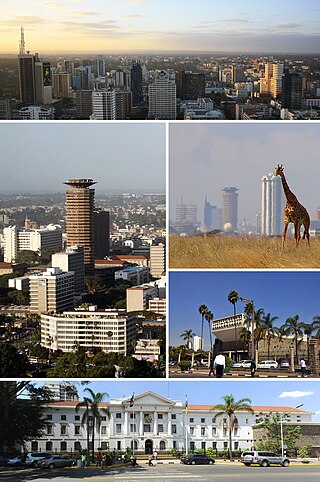
Nairobi is the capital and largest city of Kenya. The name is derived from the Maasai phrase Enkare Nairobi, which translates to 'place of cool waters', a reference to the Nairobi River which flows through the city. The city proper had a population of 4,397,073 in the 2019 census. The city is commonly referred to as The Green City in the Sun.

Mombasa is a coastal city in southeastern Kenya along the Indian Ocean. It was the first capital of British East Africa, before Nairobi was elevated to capital status in 1907. It now serves as the capital of Mombasa County. The town is known as "the white and blue city" in Kenya. It is the country's oldest and second-largest city after Nairobi, with a population of about 1,208,333 people according to the 2019 census. Its metropolitan region is the second-largest in the country, and has a population of 3,528,940 people.

Kisumu is the third-largest city in Kenya after the capital, Nairobi, and Mombasa. It is the second-largest city after Kampala in the Lake Victoria Basin. The city has a population of slightly over 600,000. The metro region, including Maseno and Ahero, has a population of 1,155,574 people according to the 2019 Kenya Population and Housing Census which was conducted by the Kenya National Bureau of Statistics.

Nyeri is a town situated in the Central Highlands of Kenya. It is the county headquarters of Nyeri County. The town was the central administrative headquarters of the country's former Central Province. Following the dissolution of the former provinces by Kenya's new constitution on 26 August 2010, the city is situated about 150 km north of Kenya's capital Nairobi, in the country's densely populated and fertile Central Highlands, lying between the eastern base of the Aberdare (Nyandarua) Range, which forms part of the eastern end of the Great Rift Valley, and the western slopes of Mount Kenya.

Uasin Gishu County is one of the 47 counties of Kenya located in the former Rift Valley Province. Eldoret has the county's largest population centre as well as its administrative and commercial centre. "It lies between longitudes 34 degrees 50' east and 35 degrees 37' West and latitudes 0 degrees 03' South and 0 degrees 55' North. It is a highland plateau with altitudes falling gently from 2,700 meters above sea level to about 1,500 meters above sea level. The topography is higher to the east and declines gently towards the western border".
Bungoma is the capital of Bungoma County in Kenya. It was established as a trading centre in the early 20th century. It is located in Kenya's fertile Western region and at the foot of Mount Elgon, Kenya's second-tallest mountain. The town and the surrounding areas boast one of Kenya's highest average rainfalls, making Bungoma one of the nation's most important food baskets.
Embu is a town located approximately 125 kilometres (78 mi) northeast of Nairobi towards Mount Kenya. Embu served as the provincial capital of the former Eastern Province and currently serves as the headquarters of Embu County in Kenya. Located on the south-eastern foothills of Mount Kenya, the Municipality of Embu had a population of 204,979 in 2019 census. Embu is also the 8th Largest Municipality in Kenya. It is the commercial hub of the Central Eastern part of Kenya and provides an avenue for trade, tourism and highway transit between the national capital and the Northern Frontier.

Nakuru is a city in the Rift Valley region of Kenya. It is the capital of Nakuru County, and is the third largest urban area in Kenya. As of 2019, Nakuru has an urban population of 570,674, making it the largest urban centre in the Rift Valley, succeeding Eldoret, Uasin Gishu County. The city lies along the Nairobi–Nakuru Highway, 160 kilometres (99 mi) from Nairobi.

Isiolo is a town in Isiolo County, of which it is the capital. It is located in the upper eastern region of Kenya and is geographically considered the center of the country Kenya. It lies 285 kilometers north of the capital Nairobi. The town grew around the local military camps. Much of the population consists of Somali, Borana and Ameru community. The town has an estimated population of 78,250, most of them living around the outskirts of the town. Like most African cities, there has been a steady increase in the urban population in recent years, especially moving from as far as Moyale, Marsabit and Mandera. Isiolo town is also becoming a centre of interest because of its newly acquired status as a resort city cashing in on the popular Samburu and Shaba Game reserves, which have become preferred destinations after the famed Maasai Mara. Isiolo lies along the long A2 Road, leading towards Marsabit and Moyale much further north.
Kisii is a municipality and urban centre in south-western Kenya and the capital of Kisii County. Kisii Town also serves as a major urban and commercial centre in the Gusii Highlands—Kisii and Nyamira counties—and the South Nyanza region and is the second largest town in formerly greater Nyanza after Kisumu City. Kisii municipality sits right at the centre of the western Kenya tourist circuit that includes the Tabaka Soapstone Carvings, Maasai Mara, Ruma National Park and part of the Lake Victoria Basin.
Voi is the largest town in Taita-Taveta County in southern Kenya, in the former Coast Province. It lies at the western edge of the Taru Desert, south and west of the Tsavo East National Park. The Sagala Hills are to the south.

Kisumu County is one of 47 counties in the Republic of Kenya. Its borders follow those of the original Kisumu District, one of the former administrative districts of the former Nyanza Province in western Kenya. Its headquarters is Kisumu City which is the third largest city in Kenya after the capital Nairobi and the coastal city of Mombasa. It has a population of 1,155,574. The land area of Kisumu County totals 2085.9 km2.

Narok County is a county in southwestern Kenya with an estimated population of 1,157,873 according to 2019 Census. The dominant ethnic group is the Maasai. Its capital and largest town is Narok, with the only other major urban centre being Kilgoris. Narok County Government was formed by the County Governments Act of 2012 as prescribed in the 2010 Constitution of Kenya. Narok County governor is Patrick Ole Ntutu after winning in the 2022 elections and his Deputy is Tamalinye K. Koech.
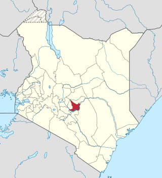
Embu County is a county of the Republic of Kenya. The capital of Embu County and the former Eastern province headquarters, Embu is a large and largely metropolitan area with a population of 608,599 persons. The county borders Kirinyaga to the west, Kitui to the east, Tharaka Nithi to the north and Machakos to the south. The county occupies an area of 2,821 km2.
Marakwet District is a defunct administrative district in the former Rift Valley Province of Kenya. Its capital town was Kapsowar. The district had a population of 140.629 people. Local people are predominantly of the Marakwet tribe.
Kibwezi is a town in Makueni County, Kenya.
Kozármisleny is a town in Baranya County, southern Hungary. It is south-east of the city of Pécs.

Ashbourne is a town in County Meath, Ireland. Located about 20 km north of Dublin and close to the M2 motorway, Ashbourne is a commuter town within Greater Dublin. In the 26 years between the 1996 and 2022 census, the town tripled in population from approximately 4,900 to 15,680 inhabitants. The town is passed by the Broad Meadow Water, which comes from Ratoath and Dunshaughlin.

Korogocho is one of the largest slum neighbourhoods of Nairobi, Kenya. Home to 150,000 to 200,000 people pressed into 1.5 square kilometres, northeast of the city centre, Korogocho was founded as a shanty town on the then outskirts of the city.
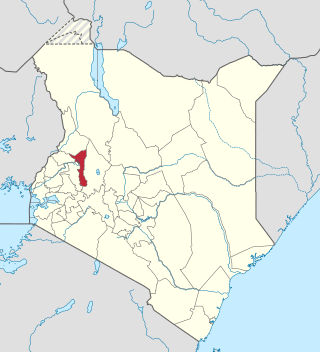
Elgeyo-Marakwet County is one of Kenya's 47 counties, which is located in the former Rift Valley Province with its capital and largest town as Iten. It borders the counties of West Pokot to the north, Baringo County to the east, southeast and south, Uasin Gishu to the southwest and west, and Trans Nzoia to the northwest.
