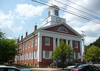
Bedford County is a county located in the U.S. state of Pennsylvania. As of the 2010 census, the population was 49,762. The county seat is Bedford.
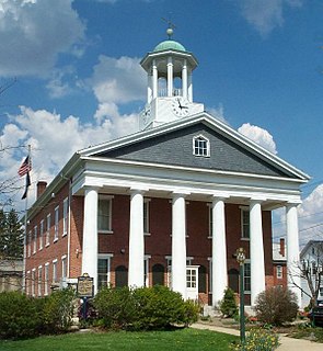
Fulton County is a county located in the U.S. state of Pennsylvania. As of the 2010 census, the population was 14,845, making it the fourth-least populous county in Pennsylvania. Its county seat is McConnellsburg. The county was created on April 19, 1850, from part of Bedford County and named for inventor Robert Fulton.

Bedford Township is a township in Bedford County, Pennsylvania, United States. The population was 5,395 at the 2010 census.

New Paris is a borough in Bedford County, Pennsylvania, United States. The population was 186 at the 2010 census.

Schellsburg is a borough in Bedford County, Pennsylvania, United States. The population was 338 at the 2010 census.
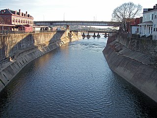
Wills Creek is a 38.6-mile-long (62.1 km) tributary of the North Branch Potomac River in Pennsylvania and Maryland in the United States.

Shawnee State Park is a 3,983-acre (1,612 ha) Pennsylvania state park in Juniata and Napier Townships, Bedford County, Pennsylvania in the United States. Shawnee Lake, a 451-acre (183 ha) warm water reservoir, is at the center of the park as its main attraction. The park's main entrance is just east of Schellsburg, along U.S. Route 30 and about 10 miles (16 km) west of the county seat of Bedford. The park is also easily accessed via State Route 31 and by State Route 96.
Clover Creek is a 24.5-mile-long (39.4 km) tributary of the Frankstown Branch Juniata River in Bedford and Blair counties, Pennsylvania, in the United States.
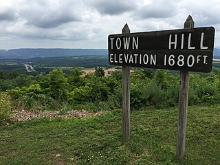
Town Hill is a mountain range located in Allegany County, Maryland and Bedford and Fulton Counties in Pennsylvania. Its southern end is 2.25 miles northwest of Kiefer in Allegany County. It trends northeasterly, and ends about 1.5 miles south of the town of Emmaville in Fulton County. Its highest elevation is 2000 feet.

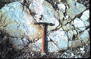
The Silurian Tuscarora Formation — also known as Tuscarora Sandstone or Tuscarora Quartzite — is a mapped bedrock unit in Pennsylvania, Maryland, West Virginia, and Virginia, USA.

Bedford County, Pennsylvania is situated along the western border of the Ridge and Valley physiographic province, which is characterized by folded and faulted sedimentary rocks of early to middle Paleozoic age. The northwestern border of the county is approximately at the Allegheny Front, a geological boundary between the Ridge and Valley Province and the Allegheny Plateau.

The Hamilton Group is a Devonian-age geological group in the Appalachian region of the United States. It is present in New York, Pennsylvania, Maryland, Ohio, West Virginia, northwestern Virginia and Ontario, Canada. It is mainly composed of marine shale with some sandstone. There are two main formations encompassed by the group: the Mahantango Formation and the Marcellus Shale. In southwestern Virginia, where the two sub-units are not easily distinguishable, the Hamilton Group is broadly equivalent to the Millboro Shale or Millboro Formation. The group is named for the village of Hamilton, New York. These rocks are the oldest strata of the Devonian gas shale sequence.
The Devonian Mahantango Formation is a mapped bedrock unit in Pennsylvania, West Virginia, and Maryland. It is named for the North branch of the Mahantango Creek in Perry and Juniata counties in Pennsylvania. It is a member of the Hamilton Group, along with the underlying the Marcellus Formation Shale. South of Tuscarora Mountain in south central Pennsylvania, the lower members of this unit were also mapped as the Montebello Formation. Details of the type section and of stratigraphic nomenclature for this unit as used by the U.S. Geological Survey are available on-line at the National Geologic Map Database.
The Marcellus Formation or the Marcellus Shale is a Middle Devonian age unit of sedimentary rock found in eastern North America. Named for a distinctive outcrop near the village of Marcellus, New York, in the United States, it extends throughout much of the Appalachian Basin.

Rays Hill is a mountain ridge in Pennsylvania's Ridge and Valley Appalachians region. It is bordered to the east by Sideling Hill. About halfway along its run, the west side of Rays Hill ties into Broad Top Mountain, a large plateau. On its west it is bordered by Tussey Mountain south of Broad Top Mountain and Rocky Ridge north of Broad Top Mountain.
The Devonian Old Port Formation is a mapped bedrock unit in Pennsylvania, USA. Details of the type section and of stratigraphic nomenclature for this unit as used by the U.S. Geological Survey are available on-line at the National Geologic Map Database. Current nomenclature usage by U.S. Geological Survey restricts the name Old Port Formation to Pennsylvania, but correlative units are present in adjacent states.
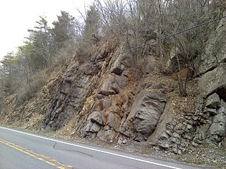
The Late Silurian to Early Devonian Keyser Formation is a mapped limestone bedrock unit in Pennsylvania, Maryland, Virginia, and West Virginia.

The Devonian Foreknobs Formation is a mapped bedrock unit in Pennsylvania, Maryland, Virginia, and West Virginia.

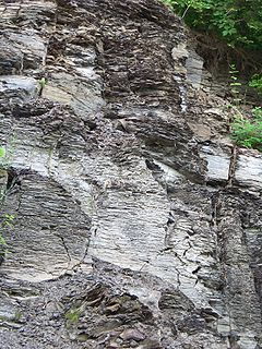
The Devonian Brallier Formation is a mapped bedrock unit in Pennsylvania, Maryland, West Virginia, and Virginia.
The Devonian Harrell Formation is a mapped bedrock unit in Pennsylvania, Maryland, West Virginia, and Virginia.

