
The Schuylkill Expressway, locally known as "the Schuylkill", is a freeway through southern Montgomery County and Philadelphia. It is the easternmost segment of Interstate 76 (I-76) in the U.S. state of Pennsylvania. It extends from the Valley Forge interchange of the Pennsylvania Turnpike in King of Prussia, paralleling its namesake Schuylkill River for most of the route, southeast to the Walt Whitman Bridge over the Delaware River in South Philadelphia. It serves as the primary corridor into Philadelphia from points west. Maintenance and planning for most of the highway are administered through Pennsylvania Department of Transportation (PennDOT) District 6, with the Delaware River Port Authority (DRPA) maintaining the approach to the Walt Whitman Bridge.

Broad Street Station at Broad and Market streets in Philadelphia was the primary passenger terminal for the Pennsylvania Railroad (PRR) in the city from December 1881 until the 1950s. Located directly west of Philadelphia City Hall, the site is now occupied by the northwest section of Dilworth Park and the office towers of Penn Center.

Philadelphia's Baltimore and Ohio Railroad station – also known as the B & O station or Chestnut Street station – was the main passenger station for the Baltimore and Ohio Railroad in Philadelphia, Pennsylvania. Designed by architect Frank Furness in 1886, it stood at 24th Street and the Chestnut Street Bridge from 1888 to 1963.

Pennsylvania Route 23 is an 81.14-mile-long (130.58 km) state highway in southeastern Pennsylvania. The route begins at PA 441 in Marietta and heads east to U.S. Route 1 at City Avenue on the border of Lower Merion Township and Philadelphia. PA 23 begins at Marietta in Lancaster County and continues east to Lancaster, where it passes through the city on a one-way pair of streets and intersects US 222 and US 30.

The Phoenix Iron Works, located in Phoenixville, Pennsylvania, was a manufacturer of iron and related products during the 19th century and early 20th century. Phoenix Iron Company was a major producer of cannon for the Union Army during the American Civil War. The company also produced the Phoenix column, an advance in construction material. Company facilities are a core component of the Phoenixville Historic District, a National Register of Historic Places site that was in 2006 recognized as a historic landmark by ASM International.

The West Philadelphia Elevated, also known as the High Line or Philadelphia High Line, is a railroad viaduct in the western part of Philadelphia, Pennsylvania. Now part of the Harrisburg Subdivision of CSX Transportation, the viaduct was built in 1903 by the Pennsylvania Railroad (PRR) to allow through freight trains to bypass rail yard, industrial sidings, and a passenger station.
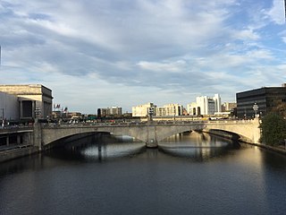
The Market Street Bridge carries Market Street, the primary east-west street in Philadelphia, Pennsylvania, across the Schuylkill River. The current bridge is the fifth permanent structure built at the site.

Chestnut Street is a major historic street in Philadelphia, Pennsylvania. It was originally named Wynne Street because Thomas Wynne's home was there. William Penn renamed it Chestnut Street in 1684. It runs east–west from the Delaware River waterfront in downtown Philadelphia through Center City and West Philadelphia. The road crosses the Schuylkill River on the Chestnut Street Bridge. It serves as eastbound Pennsylvania Route 3 between 63rd and 33rd Streets.
Strickland Landis Kneass was an American civil engineer, municipal surveyor, and railroad president.

Wilson Brothers & Company was a prominent Victorian-era architecture and engineering firm based in Philadelphia, Pennsylvania. The company was regarded for its structural expertise.

Gray's Ferry Bridge has been the formal or informal name of several floating bridges and four permanent ones that have carried highway and rail traffic over the Schuylkill River in Philadelphia. The bridge today is a four-lane divided highway bridge, built in 1976, that carries Grays Ferry Avenue from the Grays Ferry neighborhood on the east bank, over the river and the Northeast Corridor railroad tracks, to the Southwest Philadelphia neighborhood of Kingsessing.

Spring Garden Street Bridge is a highway bridge in Philadelphia, Pennsylvania. It crosses the Schuylkill River below Fairmount Dam and connects West Philadelphia to the Philadelphia Museum of Art and Benjamin Franklin Parkway. It is the fourth bridge at this location.
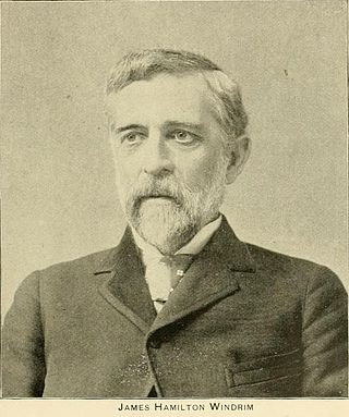
James Hamilton Windrim was a Philadelphia architect who specialized in public buildings, including the Masonic Temple in Philadelphia and the U.S. Treasury. A number the buildings he designed are on the National Historic Landmarks and/or the National Register of Historic Places, including the Masonic Temple in Philadelphia and the National Savings and Trust Company building in Washington, DC.

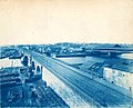
Pennsylvania Railroad, Connecting Railway Bridge is a stone arch bridge in Philadelphia, Pennsylvania, that carries Amtrak Northeast Corridor rail lines and SEPTA and NJT commuter rail lines over the Schuylkill River. It is located in Fairmount Park, just upstream from the Girard Avenue Bridge.

Chain Bridge at Falls of Schuylkill was an 1808 iron-chain suspension bridge built across the Schuylkill River, north of Philadelphia, Pennsylvania. Designed by inventor James Finley, it became the model for his later chain suspension bridges. It collapsed in 1816 under a heavy load of snow.

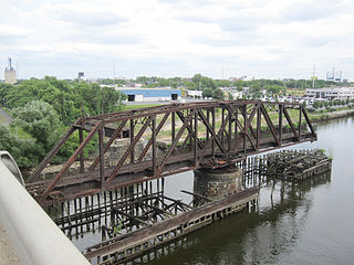
Schuylkill Arsenal Railroad Bridge is a wrought iron, two-track, deck truss swing bridge across the Schuylkill River between the University City and Grays Ferry neighborhoods of Philadelphia, Pennsylvania. It was built in 1885–86 by the Pennsylvania Railroad. Today, its swing span has been fixed shut, and the electrical catenary de-energized.
Thomas Somerville Stewart was a Philadelphia architect, engineer, and real estate developer.
Philadelphia, Wilmington and Baltimore Railroad Bridge No. 1 was a swing steel through truss that spanned the Schuylkill River between Philadelphia, Pennsylvania's Kingsessing and Grays Ferry neighborhoods.
Samuel Honeyman Kneass (1806–1858) was an American civil engineer and architect.
John Henry Dye was an American civil engineer and surveyor based in Philadelphia, Pennsylvania. His 1869 city map, made with printer Henry J. Toudy, has been described as "a major milestone in the urban mapping of Philadelphia."


