
Chiapas, officially the Free and Sovereign State of Chiapas, is one of the states that make up the 32 federal entities of Mexico. It comprises 124 municipalities as of September 2017 and its capital city is Tuxtla Gutiérrez. Other important population centers in Chiapas include Ocosingo, Tapachula, San Cristóbal de las Casas, Comitán and Arriaga. It is the southernmost state in Mexico, and it borders the states of Oaxaca to the west, Veracruz to the northwest and Tabasco to the north, and the Petén, Quiché, Huehuetenango, and San Marcos departments of Guatemala to the east and southeast. Chiapas has a coastline on the Pacific Ocean to the south.

Tuxtla Gutiérrez is the capital and the largest city of the Mexican southeastern state of Chiapas. It is the seat of the municipality of the same name, the most developed and populated in the state. A busy government, commercial and services-oriented city, Tuxtla had one of the fastest-growing rates in Mexico in the last 40 years. Unlike many other areas in Chiapas, it is not a major tourist attraction, but a transportation hub for tourists coming into the state, with a large airport and a bus terminal.

Comitán is the fourth-largest city in the Mexican state of Chiapas. It is the seat of government of the municipality of the same name.
Las Choapas is a city and its surrounding municipality in the southeastern extremes of the state of Veracruz in Mexico. It is bordered by the municipalities of Uxpanapa, Minatitlán, Moloacán, and Agua Dulce in Veracruz, Huimanguillo in Tabasco, Cintalapa and Tecpatán in Chiapas, and Santa María Chimalapa in Oaxaca. Its major products are cattle breeding, corn, oil, fruit, sugar, and rubber. In the past it had a rice miller. It is one of the largest municipalities in Veracruz, with an area of 2,851.2 km². At the 2005 census the city had a population of 40,773 inhabitants, while the municipality had a population of 70,092. It is a very hot place, as temperature reaches up to 40 degrees Celsius. It has had some tornadoes in the past. It is connected to the communities of Raudales-Ocozocoautla in Chiapas through the Chiapas bridge.

Sumidero Canyon is a deep natural canyon located just north of the city of Chiapa de Corzo in the state of Chiapas, in southern Mexico. The canyon's creation began around the same time as the Grand Canyon in the U.S. state of Arizona, by a crack in the area's crust and subsequent erosion by the Grijalva River, which still runs through it. Sumidero Canyon has vertical walls which reach as high as 1,000 metres (3,300 ft), with the river turning up to 90 degrees during the 13-kilometre (8.1 mi) length of the narrow passage.

Ocozocoautla de Espinosa, colloquially Coita, is a town and municipality in the Mexican state of Chiapas. It is located in the western part of the state, 24 km west of Tuxtla Gutierrez covering parts of the Depresión Central and the Montañas del Norte. It is bordered to the north by Tecpatán, to the east by Berriozábal, Tuxtla Gutiérrez and Suchiapa, to the south by Villaflores and to the west by Jiquipilas and Cintalapa. The name comes from the Nahoa language and means ‘forest of ocozote trees’. ‘De Espinosa’ was added in 1928 to honor Raymundo Enríquez Espinosa who was the first governor of the state of Chiapas. Ocozocoautla gained city status in 1926. The climate is warm and humid and the vegetation is mostly high and medium rainforest.

Palenque is a city and municipality located in the north of the state of Chiapas, Mexico. The city was named almost 200 years before the nearby Mayan ruins were discovered in the 18th century. The area has a significant indigenous population, mostly of the Ch'ol people, a Mayan descendant. The city is the only urban area in a municipality of over 600 communities, and is surrounded by rainforest. Deforestation has had dramatic effects on the local environment, with howler monkeys occasionally seen in the city as they seek food. While most of the municipality's population is economically marginalized, working in agriculture, the Palenque archeological site is one of the most important tourist attractions for the area and the state of Chiapas. It is the poorest major city in the state of Chiapas.
Federal Highway 187 is a Federal Highway of Mexico. The highway travels from El Bellote, Centla Municipality, Tabasco in the north to Raudales Malpaso, Tecpatán Municipality, Chiapas in the south. Federal Highway 187 is one of two major north-south highway corridors in Tabasco. Federal Highway 187 route numbering continues as the Federal Highway 187D toll road from Raudales Malpaso south to Mexican Federal Highway 190 east of Ocozocoautla de Espinosa.
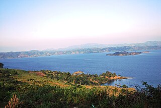
The Malpaso Dam, officially known as the Nezahualcóyotl Dam, is located in the Centro region of Chiapas, Mexico near the border with Tabasco and Veracruz. It was the first of several major dams built on the Grijalva River to generate hydroelectric energy and has the second largest reservoir in Mexico, after the Belisario Dominguez Dam. Construction of the dam occurred in the 1960s and flooded not only the riverbed but also hectares of rainforest and farmland, various towns and villages and archeological sites. These include the former town of Quechula, whose 16th century Dominican church will appear when water is at low levels, and the archeological site of San Isidro which contains one of only two known double Mesoamerican ball courts. Commissioning of the dam's 1,080 MW power station began in 1969 and ended in 1977. The reservoir and later construction of a federal highway has spurred ecotourism in the area.

Las Choapas is a recently found archaeological site located within the municipality of Las Choapas, in the southeastern border of the Veracruz State, inside the San Miguel de Allende Ejido, bordering the municipalities of Huimanguillo, Tabasco and Ostuacán, in Chiapas.

The Regional Museum of Anthropology and History of Chiapas is the largest museum in Tuxtla Gutiérrez in Chiapas and one of the most important of its kind in Mexico. It primarily consists of two main halls with one dedicated to the state’s Mesoamerican archeology and the other to the history of the state starting from the Spanish conquest. The archeological display focus on the native Zoque and Mayan cities, and the historical displays extend in time until the early 20th century. In addition to its permanent collection, it also has a temporary exhibit hall and auditorium to host events such as book signings, summer classes, conferences and more.

The 1995 Chiapas earthquake occurred on . The epicenter was located in Ocozocoautla de Espinosa, in the state of Chiapas, Mexico, near Tuxtla Gutiérrez. It had a magnitude of 7.2, or 6.5. Building damage was reported. Around 70 people were reported injured. In Tuxtla Gutiérrez, telephone and electricity services were momentarily interrupted. This earthquake could be felt strongly in Mexico City and in many parts of southern Mexico. It could also be felt in Guatemala and El Salvador. The centroid mechanism is of thrust faulting with a small strike-slip component. The rupture of this earthquake propagated from NW to SE over a distance of about 30 km. The duration of the rupture was about 17 s. The earthquake was resulted from the internal deformation of the Cocos Plate, which is subducting beneath the North American Plate.

Puerto Arista is a small community and tourist attraction located on the north coast of Chiapas, Mexico in the municipality of Tonalá. While it originally was a port, its lack of harbor and suitability for large cargo ships eventually shifted the economy to tourism in the 20th century. It is popular with people from Chiapas as it is located close to the state capital of Tuxtla Gutiérrez as well as the regional city of Tonalá. It is the most visited beach in Chiapas and one of its most popular tourist destinations, despite its relative lack of sophisticated tourism infrastructure. Puerto Arista is home of one of the state’s four marine turtle sanctuaries, design to help protect the various species which come here to lay their eggs.

Sima de las Cotorras is a sinkhole located in the El Ocote Biosphere Reserve in western Chiapas, southern Mexico. It is one of a number of sinkholes in the area, all produced by tectonic and erosive processes on the region's limestone. Although not the largest and deepest of the area's sinkholes, it is best known because of a tourism project which focuses on the thousands of Mexican green parakeets who live there most of the year, flying in and out in circular patterns.
Quechula is the name for a now-submerged village located in Chiapas, Mexico. The town was founded in the mid-1500s by Bartolomé de las Casas. The city was of strategic importance because it laid on the El Camino Real, a road that connected many important settlements in central Mexico, including Mérida and Campeche City. A large, grandiose church was constructed in the town due to the belief that the city would one day boast a large population. However, this never came to pass, and according to Carlos Navarrete, an architect who assisted with a report on the structure, it is unlikely the church ever had an official priest and it was probably served only by priests from other local dioceses.
Federal Highway 187D is a toll highway connecting Las Choapas, Veracruz to Ocozocuautla, Chiapas. The road is operated by Caminos y Puentes Federales, which charges 195 pesos for the entire course of route.
Federal Highway 190D is the tolled Federal Highway that parallels Federal Highway 190. Highways with the 190D signage are in the states of Oaxaca and Chiapas.

Mezcalapa is a municipality in the Mexican state of Chiapas, located approximately 71 kilometres (44 mi) northwest of the state capital of Tuxtla Gutiérrez. Its municipal seat is Raudales Malpaso.
El Parral is a municipality in the Mexican state of Chiapas, located approximately 45 kilometres (28 mi) south of the state capital of Tuxtla Gutiérrez.
Selva El Ocote is a biosphere reserve in Mexico. It includes mid-elevation and highland rain forests and extensive caverns.


