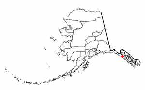
Elfin Cove is a census-designated place (CDP) near the northwestern corner of Chichagof Island in Hoonah-Angoon Census Area, Alaska, United States. The population was 20 at the 2010 census, down from 32 at the 2000 census.

The Alexander Archipelago is a 300-mile (480 km) long archipelago, or group of islands, of North America off the southeastern coast of Alaska. It contains about 1,100 islands, which are the tops of the submerged coastal mountains that rise steeply from the Pacific Ocean. Deep channels and fjords separate the islands and cut them off from the mainland. The northern part of the Inside Passage is sheltered by the islands as it winds its way among them.

Mitkof Island is an island in the Alexander Archipelago in southeast Alaska between Kupreanof Island to the west and the Alaskan mainland to the east. It is approximately 16 km (9.9 mi) wide and 28 km (17 mi) long with a land area of 539.7 km2 (208.4 sq mi), making it the 30th largest island in the United States. Much of the island is managed as part of the Tongass National Forest.

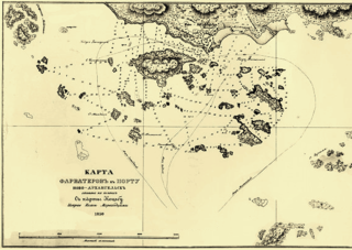
The Wrangell Narrows is a winding, 35-km-long (22 mi) channel between Mitkof Island and Kupreanof Island in the Alexander Archipelago in Southeast Alaska. The Wrangell Narrows is one of the six Listed narrows in Southeast Alaska. There are about 60 lights and buoys to mark it because of its winding nature and navigation hazards. It was named "Proliv Vrangelya" in 1838 by G. Lindenberg after Admiral Baron Ferdinand Petrovich von Wrangell. The translation Wrangell Strait remained in use while Wrangell Narrows referred to the narrowest central portion. By 1919 Department of Commerce nautical chart 8170 was changed from Wrangell Strait to Wrangell Narrows.
Chatham Strait, or Shee ya xhaak in the Tlingit language, is a narrow passage of the Alexander Archipelago in the southeastern region of the U.S. state of Alaska. It separates Chichagof Island and Baranof Island to its west from Admiralty Island and Kuiu Island on its east.

Vasili Yakovlevich Chichagov was an admiral in the Russian Navy and an explorer. He was the father of Pavel Chichagov, a Russian admiral during the Napoleonic Wars.

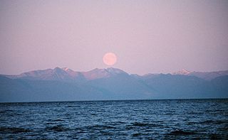
Chichagof Island, or Shee Kaax, is an island in the Alexander Archipelago of the Alaska Panhandle. At 75 miles (121 km) long and 50 miles (80 km) wide, it has a land area of 2,048.61 square miles (5,305.9 km2), making it the fifth largest island in the United States and the 109th largest island in the world. Its coastline measures 742 miles. There was a 2000 census population of 1,342 persons. It is one of the ABC islands of Alaska. Chichagof Island has the highest population of bears per square mile of any place on Earth.
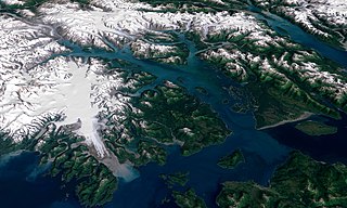
The Icy Strait is a strait in the Alexander Archipelago in southeastern Alaska, at about 58°16′41″N135°38′48″W. The strait separates Chichagof Island to the south and the Alaska mainland to the north. The strait is 64 km (40 mi) from its west side at the intersection of the Cross Sound and Glacier Bay to its east side at Chatham Strait and the Lynn Canal. The two largest islands in the strait are Pleasant Island and Lemesurier Island.

Peril Strait or Háat Ishkáak is a strait in the Alexander Archipelago in southeastern Alaska. It is between Chichagof Island to its north and Baranof Island and Catherine Island to its south. The strait is 80 km (50 mi) long and reaches from Salisbury Sound on the west to the Chatham Strait on the east. It is entirely within the limits of the City and Borough of Sitka.

Zimovia Strait is a narrow strait in the Alexander Archipelago in the U.S. state of Alaska. It is about 100 km (60 mi) long and bounded by Wrangell Island to the east and Woronkofski and Etolin Islands to the west. The strait is shown in an 1844 Russian chart, but the name was first published in 1853 on a Russian Hydrographic Department chart as "Proliv Zimov'ya".
Zarembo Island is an island in the Alexander Archipelago of southeastern Alaska, United States. It lies directly south of Mitkof Island and northwest of Etolin Island. To the northwest is Kupreanof Island and to the southwest is Prince of Wales Island. It has a land area of 183.14 square miles, making it the 34th largest island in the United States. It has no permanent resident population. It was first charted in 1793 by James Johnstone, one of George Vancouver's officers during his 1791-95 expedition. He only charted its north, west, and south coasts, not realizing it was an island. The island is named after Dionysius Zarembo, a Polish employee of the Russian American Company and explorer of Alaska. Usually known as Dionysius Zarembo, he was captain of the Russian-American Company ship Chichagof during the foundation of the Redoubt San Dionisio, named for his name-saint, a fortification at present-day Wrangell which was established to forestall encroachment on the Stikine region by the Hudson's Bay Company.
Wrangell Island is in the Alexander Archipelago in the Alaska Panhandle of southeastern Alaska. It is 48 kilometres long and 8 to 23 kilometres wide. It has a land area of 544.03 square kilometres, making it the 29th largest island in the United States. Wrangell is separated from the mainland by the narrow Blake Channel.
Mikhail Dmitriyevich Tebenkov was a Russian hydrographer and vice admiral of the Imperial Russian Navy. From 1845 to 1850, he served as director of the Russian American Company and the governor of Russian America.

Chichagof Harbor is an inlet on the northeast coast of the island of Attu in the Aleutian Islands in Alaska. It is named after Russian Admiral and polar explorer Vasily Chichagov. It is the location of the Aleut village served by an American pastor and his wife. It was also where some heavy fighting took place during the recapture of the island from the Japanese during the Battle of Attu in World War II and afterwards was the site of Battery B 42nd Coast Artillery Battalion.
The Stikine Strait is a strait in the Alexander Archipelago of Alaska, located between Zarembo Island to the west and Etolin and Woronkofski Islands just southwest of the City of Wrangell. The strait's name derives from that of the Stikine River, the outlet of which is just northeast of Wrangell. The strait is shown on an 1844 Russian chart, but the name was first published on Russian Admiralty charts in 1848 as Proliv Stakhinskiy or Stakhin Strait. Other spelling variants over time have been Frances Strait, Stachin Strait, Stachine Strait, Stackine Strait, Stahkeen Strait, Stahkin Strait, Stakeen Strait, Stakhinski Strait, Stickeen Strait, and Stikeen Strait
Chichagov or Chichagof(f) (masculine) or Chichagova (feminine) is a Russian surname. Notable people with the surname include:
Stuyvesant Falls is a hamlet in the town of Stuyvesant in Columbia County, New York, United States. The zipcode is: 12174. It was called Glencadia is the 18th century. The French—Scottish derivatives of Glencadia apparently mean a "creek region of simple pleasures." The name seemed to change in the early 19th century although a book published in 1914 refers to the village by the name Glencadia, not Stuyvesant Falls.
KMWC 89.9 FM is a radio station licensed to Bethany, Missouri. The station broadcasts a Christian Talk and Teaching format and is owned by Penfold Communications, Inc.

Bayqadam is a town in Aktobe Region, west Kazakhstan. It lies at an altitude of 165 m (541 ft).

