
Monrovia is the capital city of the West African country of Liberia. Located on the Atlantic Coast at Cape Mesurado, Monrovia had a population of 1,010,970 as of the 2008 census. With 29% of the total population of Liberia, Monrovia is the country's most populous city.

Montserrado County is a county in the northwestern portion of the West African nation of Liberia. One of 15 counties that comprise the first-level of administrative division in the nation, it is composed of four districts. As of the 2008 Census, it had a population of 1,118,241, making it the most populous county in Liberia. The area of the county measures 1,912.7 square kilometres (738.5 sq mi), the smallest in the country. Bensonville serves as the capital.
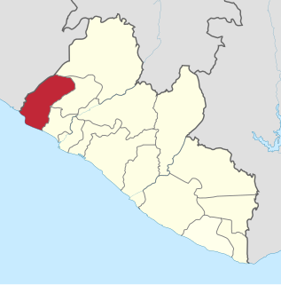
Grand Cape Mount is a county in the northwestern portion of the West African nation of Liberia. One of 15 counties that constitute the first-level of administrative division in the nation, it has five districts. Robertsport serves as the capital with the area of the county measuring 5,162 square kilometres (1,993 sq mi). As of the 2008 Census, it had a population of 129,817, making it the eighth most populous county in Liberia. The county is bordered by Gbarpolu County to the northeast and Bomi County to the southeast. The northern part of Grand Cape Mount borders the nation of Sierra Leone, while to the west lies the Atlantic Ocean.

Bomi is a county in the northwestern portion of the West African nation of Liberia. The county was established in 1984. The county's area is 746 square miles (1,900 km2).

Bong is a county in the north-central portion of the West African nation of Liberia. One of 15 counties that comprise the first-level of administrative division in the nation, it has twelve districts. Gbarnga serves as the capital. The area of the county measures 8,772 square kilometres (3,387 sq mi). As of the 2008 Census, it had a population of 328,919, making it the third-most populous county in Liberia. The county was organized in 1964 and is important for its mining industry.

Margibi is a county on the north to central coast of Liberia. One of 15 counties that constitute the first-level of administrative division in the nation, it has five districts. Kakata serves as the capital with the area of the county measuring 2,616 square kilometres (1,010 sq mi). As of the 2008 Census, it had a population of 199,689, making it the sixth most populous county in Liberia.
Careysburg District is one of four districts located in Montserrado County, Liberia. Bensonville is the capital, and the total district population is 28,463.
Greater Monrovia is one of four districts located in Montserrado County, Liberia. It contains the country's capital Monrovia. It recorded a population of 970,824 in the 2008 census.
St. Paul River is a district located in Montserrado County, Liberia. It recorded a population of 71,831 in the 2008 census. It has no official administrative status. Its inhabitants are primarily Christians and members of the Bassa, Dey, or Kpelle tribes. Farming and fishing are the main economic activities along with some small scale trading. The district has one paved road.
The Liberian National Police is the national police force in Liberia. INTERPOL says that the LNP's mandate is to "..To maintain public order and safety; To protect people and property; To identify and recover lost and stolen property; To prevent, detect and fight crime; To identify and arrest criminals; and to To enforce the law and testify in court."

West Point is a township of the Liberian capital city of Monrovia, located on a 0.25 km2 peninsula which juts out into the Atlantic Ocean between the Mesurado and Saint Paul rivers. West Point is one of Monrovia's most densely populated slums.
Caldwell is a township located in Montserrado County, Liberia. Caldwell was one of the four townships established in the first wave of colonization. It is listed as one of the original settlements comprising the Commonwealth of Liberia in the 1839 Constitution, which was drafted by the American Colonization Society. The name comes from Elias B. Caldwell and family, about 1816, Presbyterians in what became Caldwell, New Jersey.

New Georgia is a township in Montserrado County, Liberia that was first settled by Africans who had been taken from slave ships seized or wrecked near the United States and then sent to Liberia after several years had passed.
Chocolate City is a central-northern suburb of Monrovia, Liberia. It is located in the New Georgia Township. Chocolate City contains the Elizabeth Blunt School and Francis Freeman Elementary School.
Kaba Town is a community in Bardnesville Township, Greater Monrovia District, Liberia. As of 2014 the population of Kaba Town was estimated at 6,740. Kaba Town is part of the Montserrado-11 electoral district.
New Kru Town is a northwestern coastal suburb of Monrovia, Liberia located on the north end of Bushrod Island. It is the only borough in Liberia.
Key & Death Hole is a community in the township of Congo Town, Greater Monrovia District, Liberia. The community is located on the eastern, i.e. Old Road, side of the Spriggs Payne Airport. The name Death Hole stems from massacres of the Liberian Civil War, occuring near the airfield in 1990. An alternative name for the area is Tweh-Johnsonville, after Matthew Tweh and Rt. Gen. J. Samuel Johnson.
Swankamore is a community in Paynesville City Corporation, Greater Monrovia District, Liberia. The community is located SKD Boulevard.
Dixville is a township in Greater Monrovia District, Montserrado County, Liberia. The Dixville township was one of five townships founded in the second wave of colonization, between 1828 and 1847.