Related Research Articles

Liberia, officially the Republic of Liberia, is a country on the West African coast. It is bordered by Sierra Leone to its northwest, Guinea to its north, Côte d'Ivoire to its east, and the Atlantic Ocean to its south-southwest. It has a population of around 5 million and covers an area of 111,369 square kilometers (43,000 sq mi). English is the official language, but over 20 indigenous languages are spoken, representing the numerous ethnic groups who make up more than 95% of the population. The country's capital and largest city is Monrovia.

Monrovia is the capital city of the West African country of Liberia. Located on the Atlantic Coast at Cape Mesurado, Monrovia had a population of 1,010,970 as of the 2008 census. With 29% of the total population of Liberia, Monrovia is the country's most populous city.

Montserrado County is a county in the northwestern portion of the West African nation of Liberia. One of 15 counties that comprise the first-level of administrative division in the nation, it is composed of four districts. As of the 2008 Census, it had a population of 1,118,241, making it the most populous county in Liberia. The area of the county measures 1,912.7 square kilometres (738.5 sq mi), the smallest in the country. Bensonville serves as the capital.
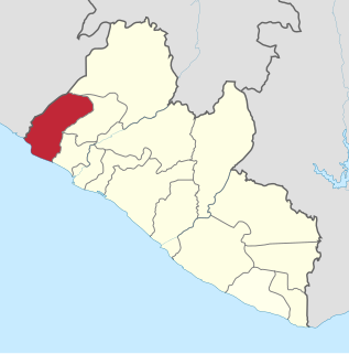
Grand Cape Mount is a county in the northwestern portion of the West African nation of Liberia. One of 15 counties that constitute the first-level of administrative division in the nation, it has five districts. Robertsport serves as the capital with the area of the county measuring 5,162 square kilometres (1,993 sq mi). As of the 2008 Census, it had a population of 129,817, making it the eighth most populous county in Liberia. The county is bordered by Gbarpolu County to the northeast and Bomi County to the southeast. The northern part of Grand Cape Mount borders the nation of Sierra Leone, while to the west lies the Atlantic Ocean.

Bomi is a county in the northwestern portion of the West African nation of Liberia. The county was established in 1984. The county's area is 746 square miles (1,900 km2).

Bong is a county in the north-central portion of the West African nation of Liberia. One of 15 counties that comprise the first-level of administrative division in the nation, it has twelve districts. Gbarnga serves as the capital. The area of the county measures 8,772 square kilometres (3,387 sq mi). As of the 2008 Census, it had a population of 328,919, making it the third-most populous county in Liberia. The county was organized in 1964 and is important for its mining industry.

Margibi is a county on the north to central coast of Liberia. One of 15 counties that constitute the first-level of administrative division in the nation, it has five districts. Kakata serves as the capital with the area of the county measuring 2,616 square kilometres (1,010 sq mi). As of the 2008 Census, it had a population of 199,689, making it the sixth most populous county in Liberia.

River Gee is a county in the southern portion of Liberia. One of 15 counties that constitute the first-level of administrative division in the nation, it has six districts. Fish Town serves as the capital with the area of the county measuring 5,113 square kilometres (1,974 sq mi). As of the 2008 Census, it had a population of 66,789, making it the third-least populous county in Liberia. It was created in 2000.
Bensonville is the capital city of Montserrado County, Liberia. As of the 2008 national census, its population stood at 4,089. Bensonville is located 20 miles away from the national capital, Monrovia, which is also located in Montserrado County. It is a commercial center for the surrounding agricultural area.
St. Paul River is a district located in Montserrado County, Liberia. It recorded a population of 71,831 in the 2008 census. It has no official administrative status. Its inhabitants are primarily Christians and members of the Bassa, Dey, or Kpelle tribes. Farming and fishing are the main economic activities along with some small scale trading. The district has one paved road.

West Point is a township of the Liberian capital city of Monrovia, located on a 0.53 km2 peninsula which juts out into the Atlantic Ocean between the Mesurado and Saint Paul rivers. West Point is one of Monrovia's most densely populated slums.
Caldwell is a township located in Montserrado County, Liberia. Caldwell was one of the four townships established in the first wave of colonization. It is listed as one of the original settlements comprising the Commonwealth of Liberia in the 1839 Constitution, which was drafted by the American Colonization Society. The name comes from Elias B. Caldwell and family, about 1816, Presbyterians in what became Caldwell, New Jersey.

New Georgia is a township in Montserrado County, Liberia that was first settled by Africans who had been taken from slave ships seized or wrecked near the United States and then sent to Liberia after several years had passed.

Mary Tanyonoh Broh is the former mayor of Monrovia, the capital city of Liberia. She first served the Liberian government in March 2006 as the Special Projects Coordinator for President Ellen Johnson Sirleaf's executive staff. In 2007, she was promoted to direct the Passport Bureau in a successful attempt to curtail and eliminate corruption and bribery within the division. In 2008, Broh became the Deputy Director of the National Port Authority. In February 2009, she was selected to serve as Acting Mayor of Monrovia in place of the previous mayor, Ophelia Hoff Saytumah, in the President's effort to legitimize the Monrovia City Corporation's (MCC) administrative and financial management. Although Broh was seated in February 2009 by appointment, rather than by the usual democratic election process, she was not officially confirmed by the Liberian Senate.
Chocolate City is a central-northern suburb of Monrovia, Liberia. It is located in the New Georgia Township. Chocolate City contains the Elizabeth Blunt School and Francis Freeman Elementary School.
New Kru Town is a northwestern coastal suburb of Monrovia, Liberia. located on the north end of Bushrod Island. It is the only borough in Liberia.
The following is a timeline of the history of the city of Monrovia, Liberia.
Chicken Soup Factory is a community in Gardnesville Township, Greater Monrovia District, Liberia. The name hails from a defunct Maggi chicken bouillon cube factory located in the area.
Key & Death Hole is a community in the township of Congo Town, Greater Monrovia District, Liberia. The community is located on the eastern, i.e. Old Road, side of the Spriggs Payne Airport. The name Death Hole stems from massacres of the Liberian Civil War, occurring near the airfield in 1990. An alternative name for the area is Tweh-Johnsonville, after Matthew Tweh and Rt. Gen. J. Samuel Johnson.
Dixville is a township in Greater Monrovia District, Montserrado County, Liberia. The Dixville township was one of five townships founded in the second wave of colonization, between 1828 and 1847.
References
- ↑ "2008 Population and Housing Census Final Results" (PDF). LISGIS. May 2009. p. 14. Retrieved 16 October 2017.
- ↑ "Montserrado County Development Agenda" (PDF). Republic of Liberia. 2008. pp. 4, 29. Retrieved 16 October 2017.
- ↑ "Greater Monrovia, Liberia - Administrative Boundaries Overview" (PDF). ReliefWeb. Liberia Institute of Statistics & Geo-Information Services. Retrieved 16 October 2017.
- ↑ "Liberia Housing Profile" (PDF). United Nations Human Settlements Programme. 2014. pp. 14–15, 23. Archived from the original (PDF) on 17 October 2017. Retrieved 16 October 2017.
Coordinates: 6°18′38″N10°48′17″W / 6.31056°N 10.80472°W
| | This Liberia location article is a stub. You can help Wikipedia by expanding it. |