This article needs additional citations for verification .(May 2008) |

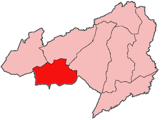
Zota District is one of twelve districts located in Bong County, Liberia.It has four third level subdivisions Upper Kpaquelleh,Zota,Lower Kpaquelleh,andGwilapolu [1] [2] [3]
This article needs additional citations for verification .(May 2008) |
Zota District is one of twelve districts located in Bong County, Liberia.It has four third level subdivisions Upper Kpaquelleh,Zota,Lower Kpaquelleh,andGwilapolu [1] [2] [3]
Settlements in Zota District include:

Morrison is a town in Brown County in the U.S. state of Wisconsin. The population was 1,599 at the 2010 census.

Lake Ripley is a census-designated place (CDP), in the town of Oakland, Jefferson County, Wisconsin, United States. The population was 1,911 at the 2020 census.

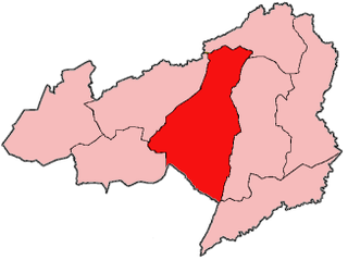
Bong is a county in the north-central portion of the West African nation of Liberia. One of 15 counties that comprise the first-level of administrative division in the nation, it has twelve districts. Gbarnga serves as the capital. The area of the county measures 8,772 square kilometres (3,387 sq mi). As of the 2022 Census, it had a population of 467,502, making it the third-most populous county in Liberia. The county was organized in 1964 and is important for its mining industry.

Fuamah District is one of twelve districts located in Bong County, Liberia. it has five third level subdivisions Lorlah,Zuluzaryea,Yarbayon,Bubli and,Zarwakuma

Jorquelleh District is one of twelve districts of Bong County, Liberia.It has five third level subdivisions Jorpoo,Bellequelleh,Jorquelle,Gbarnshay, andSheansuie
Salala District is one of twelve districts in Bong County, Liberia. Multiple internally displaced person camps are located in the district.It has four third level subdivisions Konoyea,Konowulala,Nyanforquelleh,Kpartolor

Panta-Kpa District is one of twelve districts located in Bong County, Liberia.It has four third level sub divisions, Wrunah,Panta,Waytua,and Wolota

Sanayea District is one of twelve districts located in Bong County, Liberia.It has six third level sub divisions Menquelleh,Wallahun,Deingmah,Boryermah,Sanoyea,Bonkomu
Suakoko District is one of twelve districts located in Bong County, Liberia. Moreover, it is located in the south central portion of Bong County. A majority of the residents in this district are employees with the Phebe hospital and Cuttington University main campus. Others within the area are local laborers with workers and students who come into the area in search for jobs and/or education.

The Kokoyah Administrative District is one of twelve districts located in Bong County, Liberia.It has four third level subdivisions Bonwein,Senwein,Tukpablee, and Kokoyah

Rich Knob, elevation 4,152 feet, is located in Towns County, Georgia. It is part of the Georgia portion of the Southern Nantahala Wilderness and is within the boundaries of the Tallulah Ranger District of the Chattahoochee National Forest. The mountain lies along the Appalachian Trail, which crosses over its eastern flank in Rabun County as it enters North Carolina. Rich Knob also is along the route of The Mountains-To-Sea Trail, East of Rattlesnake Lodge.
Belefuanai is a town in Zota District of Bong County, Liberia, near the border of Guinea.
Roosevelt is an unincorporated community in Lubbock County, Texas, United States. It sits at an elevation of 3136 feet. The community is part of the Lubbock Metropolitan Statistical Area. It mainly consists of Roosevelt High school. There is also a Baptist church here.
Karolinów is a village in the administrative district of Gmina Tomaszów Mazowiecki, within Tomaszów Mazowiecki County, Łódź Voivodeship, in central Poland. It lies approximately 9 kilometres (6 mi) south of Tomaszów Mazowiecki and 53 km (33 mi) south-east of the regional capital Łódź.
Omo Ranch is an unincorporated community in El Dorado County, California. It is located 12.5 miles (20 km) south-southeast of Camino, at an elevation of 3612 feet.
Oak Ridge, Pittsylvania County is an unincorporated community in Pittsylvania County, Virginia. It is known as the location of the holiday home of former British prime minister Gordon Brown.
Baker is a ghost town in Boyd County, Nebraska, United States.
Cavett is an unincorporated community in Van Wert County, in the U.S. state of Ohio.
Leonardsburg is an unincorporated community in Delaware County, in the U.S. state of Ohio.
Rocky Hill is an unincorporated community in Bloomfield Township, Jackson County, Ohio, United States. It is located southeast of Jackson along U.S. Route 35, next to Winchester at the intersection of C H & D Road and Dixon Run Road, at 38°59′20″N82°32′42″W.
6°59′20″N9°34′53″W / 6.98889°N 9.58139°W
| | This Liberia location article is a stub. You can help Wikipedia by expanding it. |