Commonwealth | |
|---|---|
| Country | |
| County | Montserrado |
| Population (2008) | |
| • Total | 11,876 |
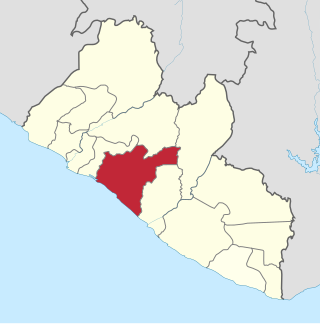
Commonwealth is a district in Montserrado County in Liberia. The population was 11,876 in 2008, according to Population and Housing Census. [1] [2]
Commonwealth | |
|---|---|
| Country | |
| County | Montserrado |
| Population (2008) | |
| • Total | 11,876 |
Commonwealth is a district in Montserrado County in Liberia. The population was 11,876 in 2008, according to Population and Housing Census. [1] [2]

Lofa is a county in the northernmost portion of Liberia. One of 15 counties that constitute the first-level of administrative division in the nation, it has nine districts. Voinjama serves as the capital with the area of the county measuring 9,982 square kilometres (3,854 sq mi). As of the 2008 Census, it had a population of 276,863, making it Liberia's third most populous county.

Grand Cape Mount is a county in the northwestern portion of the West African nation of Liberia. One of 15 counties that constitute the first-level of administrative division in the nation, it has five districts. Robertsport serves as the capital with the area of the county measuring 5,162 square kilometres (1,993 sq mi). As of the 2008 Census, it had a population of 129,817, making it the eighth most populous county in Liberia. The county is bordered by Gbarpolu County to the northeast and Bomi County to the southeast. The northern part of Grand Cape Mount borders the nation of Sierra Leone, while to the west lies the Atlantic Ocean.

Bomi is a county in the northwestern portion of the West African nation of Liberia. The county was established in 1984. The county's area is 746 square miles (1,900 km2).

Bong is a county in the north-central portion of the West African nation of Liberia. One of 15 counties that comprise the first-level of administrative division in the nation, it has twelve districts. Gbarnga serves as the capital. The area of the county measures 8,772 square kilometres (3,387 sq mi). As of the 2008 Census, it had a population of 328,919, making it the third-most populous county in Liberia. The county was organized in 1964 and is important for its mining industry.
Grand Bassa is a county in the west-central portion of the West African nation of Liberia. One of 15 counties that comprise the first-level of administrative division in the nation, it has eight districts. Buchanan serves as the capital with the area of the county measuring 7,936 square kilometres (3,064 sq mi). As of the 2008 Census, it had a population of 224,839, making it the fifth most populous county in Liberia.

Grand Gedeh is a county in the eastern portion of the West African nation of Liberia. One of 15 counties that constitute the first-level of administrative division in the nation, it has three districts. Zwedru serves as the capital with the area of the county. Measuring 10,484 square kilometres (4,048 sq mi), it is larger than 28 independent countries including Lebanon, Trinidad and Tobago, Cape Verde, Malta and Mauritius and the combined area of the US states of Delaware and Rhode Island. As of the 2008 Census, it had a population of 126,146, making it the ninth most populous county in Liberia. Grand Gedeh has lower tropical forests which has mid size hills composed of various valleys and water courses. These forests receive a very high rainfall ranging from 3,000 mm (120 in) to 4,100 mm (160 in) per year.

Margibi is a county on the north to central coast of Liberia. One of 15 counties that constitute the first-level of administrative division in the nation, it has five districts. Kakata serves as the capital with the area of the county measuring 2,616 square kilometres (1,010 sq mi). As of the 2008 Census, it had a population of 199,689, making it the sixth most populous county in Liberia.

Sinoe is one of Liberia's 15 counties and it has 17 districts. Greenville is the county's capital. As of the 2008 Census, it had a population of 104,932, making it one of the least populous counties in Liberia. Sinoe has the third-largest area of all Liberia's counties; it has the second least-dense population after Gbarpolu County. The County was originally a colony in the name Mississippi-in-Africa, under auspices of a chapter of the American Colonization Society as it was created with slaves from Mississippi to Liberia.

River Gee is a county in the southern portion of Liberia. One of 15 counties that constitute the first-level of administrative division in the nation, it has six districts. Fish Town serves as the capital with the area of the county measuring 5,113 square kilometres (1,974 sq mi). As of the 2008 Census, it had a population of 66,789, making it the third-least populous county in Liberia. It was created in 2000.

Salayea District is an administrative district located in Lofa County, Liberia. In 2008, it had a population of 23,578.
Butaw District (Buto) is one of 16 districts of Sinoe County, Liberia. As of 2008, the population was 3,892.
Greenville District is one of 16 districts of Sinoe County, Liberia. As of 2008, the population was 16,434, making it the most populous district in the county.
Sanquin District 3 is one of 16 districts of Sinoe County, Liberia. As of 2008, the population was 3,174.
Sanquin District 2 is one of 16 districts of Sinoe County, Liberia. As of 2008, the population was 3,405.
Sanquin District 1 is one of 16 districts of Sinoe County, Liberia. As of 2008, the population was 2,118.
Bearwor District is one of 8 districts of Rivercess County, Liberia. As of 2008, the population was 3,854.
Doedain District is one of 8 districts of Rivercess County, Liberia. As of 2008, the population was 13,041.
Jo River District is one of 8 districts of Rivercess County, Liberia. As of 2008, the population was 8,921.
Meinpea-Mahn District is one of 17 districts of Nimba County, Liberia. As of 2008, the population was 24,157.

Rivercess County is a county in the south-central portion of the West African nation of Liberia. One of 15 counties that compose the first-level of administrative division in the nation, it has six districts. Cesstos City serves as the capital with the area of the county measuring 5,594 square kilometres (2,160 sq mi). As of the 2008 Census, it had a population of 71,509, making it the second least populous county in Liberia after Grand Kru County.
| | This Liberia location article is a stub. You can help Wikipedia by expanding it. |