
Salala District is one of twelve districts in Bong County, Liberia. Multiple internally displaced person camps are located in the district. It has four third level subdivisions Konoyea,Konowulala,Nyanforquelleh,Kpartolor [1] [2] [3] [4]
Salala District is one of twelve districts in Bong County, Liberia. Multiple internally displaced person camps are located in the district. It has four third level subdivisions Konoyea,Konowulala,Nyanforquelleh,Kpartolor [1] [2] [3] [4]

Maryland County is a county in the southeastern portion of Liberia. One of 15 counties that comprise the first-level of administrative division in the nation, it has two districts. Harper serves as the capital with the area of the county measuring 887 square miles (2,300 km2). As of the 2022 Census, it had a population of 172,202, making it the ninth most populous county in Liberia.

Bomi is a county in the northwestern portion of the West African nation of Liberia. The county was established in 1984. The county's area is 746 square miles (1,900 km2).

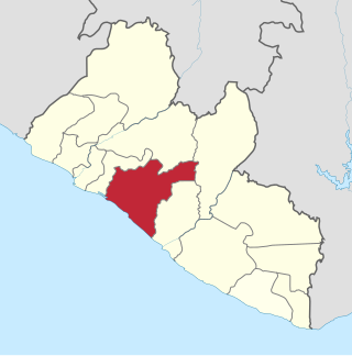
Bong is a county in the north-central portion of the West African nation of Liberia. One of 15 counties that comprise the first-level of administrative division in the nation, it has twelve districts. Gbarnga serves as the capital. The area of the county measures 8,772 square kilometres (3,387 sq mi). As of the 2022 Census, it had a population of 467,502, making it the third-most populous county in Liberia. The county was organized in 1964 and is important for its mining industry. Bong produces mostly iron ore, for example at the Bong Mine, located in Bong Town.
Grand Bassa is a county in the west-central portion of the West African nation of Liberia. One of 15 counties that comprise the first-level of administrative division in the nation, it has eight districts. Buchanan serves as the capital with the area of the county measuring 3,064 square miles (7,940 km2). As of the 2022 Census, it had a population of 293,557, making it the sixth most populous county in Liberia.
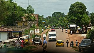
Kakata is the capital city of Liberia's Margibi County. Located in Kakata District, its proximity to the Du River bridge also comprises its border with Todee District. It is a transit town at the heart of the historical natural rubber cultivation belt in Liberia. The city is colloquially known as "Kak City".
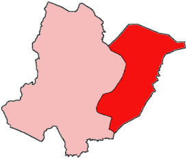
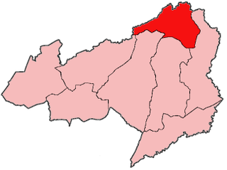
Seuhn Mecca District is one of four administrative districts of Bomi County, Liberia.

Fuamah District is one of twelve districts located in Bong County, Liberia. it has five third level subdivisions Lorlah,Zuluzaryea,Yarbayon,Bubli and,Zarwakuma

Jorquelleh District is one of twelve districts of Bong County, Liberia.It has five third level subdivisions Jorpoo,Bellequelleh,Jorquelle,Gbarnshay, andSheansuie

Panta-Kpa District is one of twelve districts located in Bong County, Liberia. It has four third-level subdivisions: Wrunah, Panta, Waytua, and Wolota.

Sanayea District is one of twelve districts located in Bong County, Liberia.It has six third level sub divisions Menquelleh,Wallahun,Deingmah,Boryermah,Sanoyea,Bonkomu
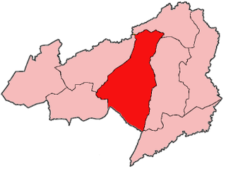
Suakoko District is one of twelve districts located in Bong County, Liberia. Moreover, it is located in the south central portion of Bong County. A majority of the residents in this district are employees with the Phebe hospital and Cuttington University main campus. Others within the area are local laborers with workers and students who come into the area in search for jobs and/or education.
Zota District is one of twelve districts located in Bong County, Liberia.It has four third level subdivisions Upper Kpaquelleh,Zota,Lower Kpaquelleh,andGwilapolu

The Kokoyah Administrative District is one of twelve districts located in Bong County, Liberia.It has four third level subdivisions Bonwein,Senwein,Tukpablee, and Kokoyah

Buah District is one of four districts located in Grand Kru County, Liberia.
Sarver is an unincorporated community in Buffalo Township, Butler County, Pennsylvania. It is located in the south-eastern part of the county. Sarver is generally known as most of the area near and west/southwest of State Route 356 in the township. Until around the late 1990s- early 2000s, Sarver was home to only a few residents. Its economy was very small and was based solely on a grocery store, a few small restaurants, along with a few gas stations and car dealerships. It has since grown to hold many new medium to high income housing plans, with the addition of many new shopping centers and businesses. The ZIP code is 16055. The population of the zip code is 8,486.

On June 22, 1951, Pan Am Flight 151, flown by the Lockheed L-049 Constellation propliner Clipper Great Republic crashed into a West African hill at an elevation of 1,050 ft (320 m) near the village of Sanoyie in Bong County, Liberia. All 31 passengers and nine crew on board were killed.
Salala may refer to:

The Saint John River is one of the six main rivers in the West African nation of Liberia. With its headwaters in neighboring Guinea, the river flows generally southwest through Liberia and empties into the Atlantic Ocean at Bassa Cove near Edina in Grand Bassa County. The 282 km (175 mi) river has a drainage basin covering 16,157 km2 (6,238 sq mi).
Salala is a town in Bong County, Liberia. It was the site of a refugee camp for over 50,000 people who have fled the violence in Liberia
{{cite web}}: Missing or empty |title= (help)6°44′45″N10°06′30″W / 6.74583°N 10.10833°W
| | This Liberia location article is a stub. You can help Wikipedia by expanding it. |