
Conecuh County is a county located in the south-central portion of the U.S. state of Alabama. As of the 2020 census the population was 11,597. Its county seat is Evergreen. Its name is believed to be derived from a Creek Indian term meaning "land of cane."

Eldridge is a city in Scott County, Iowa, United States. The population was 6,726 in the 2020 Census; Eldridge is a rural community and part of the Quad Cities metropolitan area.

Frenchtown Charter Township is a charter township within Monroe County in the U.S. state of Michigan. The population was 21,609 as per the 2020 census.

Lima Township is a civil township of Washtenaw County in the U.S. state of Michigan. The population was 4,024 at the 2020 census.
Jerseytown is a census-designated place (CDP) that is located in Madison Township, Columbia County, Pennsylvania, United States. It is part of Northeastern Pennsylvania and of the Bloomsburg-Berwick micropolitan area.

Montserrado County is a county in the northwestern portion of the West African nation of Liberia containing its national capital, Monrovia. One of 15 counties that comprise the first-level of administrative division in the nation, it has 17 sub political districts. As of the 2022 Census, it had a population of 1,920,914, making it the most populous county in Liberia. The area of the county measures 738.5 square miles (1,913 km2), the smallest in the country. Bensonville serves as the capital.

Maryland County is a county in the southeastern portion of Liberia. One of 15 counties that comprise the first-level of administrative division in the nation, it has two districts. Harper serves as the capital with the area of the county measuring 887 square miles (2,300 km2). As of the 2022 Census, it had a population of 172,202, making it the ninth most populous county in Liberia.

Central Alabama is a region in the state of Alabama. It is sometimes considered part of North Alabama because both regions are mountainous, but in some definitions they are different regions.

Gbarnga is the capital city of Bong County, Liberia, lying north east of Monrovia. During the First Liberian Civil War, it was the base for Charles Taylor's National Patriotic Front of Liberia. Cuttington College, a private, Episcopal-affiliated institution, is located near the town. Its campus was once home to the Africana Museum, which was destroyed during the civil war.

Gbarpolu is a county in the northern portion of Liberia. One of 15 counties that comprise the first-level of administrative division in the nation, it has six districts. Bopulu serves as the capital with the area of the county measuring 3,741 square miles (9,690 km2). As of the 2008 Census, it had a population of 83,758, making it the eleventh-most populous county in Liberia.

Bomi is a county in the northwestern portion of the West African nation of Liberia. The county was established in 1984. The county's area is 746 square miles (1,900 km2).

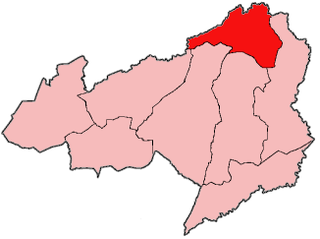
Bong is a county in the north-central portion of the West African nation of Liberia. One of 15 counties that comprise the first-level of administrative division in the nation, it has twelve districts. Gbarnga serves as the capital. The area of the county measures 8,772 square kilometres (3,387 sq mi). As of the 2022 Census, it had a population of 467,502, making it the third-most populous county in Liberia. The county was organized in 1964 and is important for its mining industry.
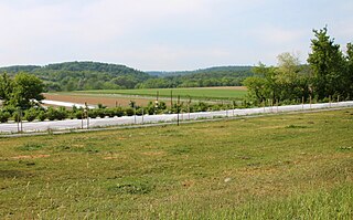
Zota District is one of twelve districts located in Bong County, Liberia.It has four third level subdivisions Upper Kpaquelleh,Zota,Lower Kpaquelleh,andGwilapolu

The Kokoyah Administrative District is one of twelve districts located in Bong County, Liberia.It has four third level subdivisions Bonwein,Senwein,Tukpablee, and Kokoyah

Kongba District is one of five second-level administrative divisions located in Gbarpolu County, Liberia.

Konobo District is one of three districts located in Grand Gedeh County, Liberia. The administrative seat of the District is Ziah Town. As of 2008, the District had 50,161 people making it the second most populated in Grand Gedeh County next to Gbarzon District. In area, it is about 1,400 square miles (3,600 km2).
Jabo is the self-designation of an ethnic group located in the southeastern part of the Republic of Liberia in West Africa. They have also sometimes referred to themselves as Gweabo or Nimiah tribe.

Jewel Cianeh Taylor is a Liberian politician who served as the 30th vice president of Liberia from 2018 to 2024. She was married to convicted warlord and former president Charles Taylor from 1997 to 2006 and was first lady of Liberia during his presidency. In 2005, Jewel Taylor was elected to the Senate of Liberia for Bong County as a member of the National Patriotic Party. She was Chair of the Senate Health and Social Welfare Committee on Gender, Women and Children.

Liberia is divided into fifteen first-level administrative divisions called counties, which, in turn, are subdivided into a total of 90 second-level administrative divisions called districts and further subdivided into third-level administrative divisions called clans.
Suah Koko was an indigenous Liberian ruler who lived between the late 19th and early 20th century. She fought several battles against the expansionary Liberia Frontier Force before entering negotiations to grant accession of the territory she ruled over to the Liberian government. She later became a paramount chief and supplied porters to the Harvard Medical African Expedition (1926–1927).
