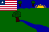
Liberia, officially the Republic of Liberia, is a country on the West African coast. It is bordered by Sierra Leone to its northwest, Guinea to its north, Ivory Coast to its east, and the Atlantic Ocean to its south and southwest. It has a population of around 5 million and covers an area of 43,000 square miles (111,369 km2). The country's official language is English; however, over 20 indigenous languages are spoken, reflecting the country's ethnic and cultural diversity. The capital and largest city is Monrovia.

Prey Veng is a province (khaet) of Cambodia. The capital is Prey Veng. With a population of 1.1 million people, it is the third most populous province.

Montserrado County is a county in the northwestern portion of the West African nation of Liberia containing its national capital, Monrovia. One of 15 counties that comprise the first-level of administrative division in the nation, it has 17 sub political districts. As of the 2022 Census, it had a population of 1,920,914, making it the most populous county in Liberia. The area of the county measures 1,912.7 square kilometres (738.5 sq mi), the smallest in the country. Bensonville serves as the capital.

Lofa is a county in the northernmost portion of Liberia. One of 15 counties that constitute the first-level of administrative division in the nation, it has nine districts. Voinjama serves as the capital with the area of the county measuring 9,982 square kilometres (3,854 sq mi). As of the 2022 Census, it had a population of 367,376, making it Liberia's fourth most populous county.

Grand Cape Mount is a county in the northwestern portion of the West African nation of Liberia. One of 15 counties that constitute the first-level of administrative division in the nation, it has five districts. Robertsport serves as the capital with the area of the county measuring 5,162 square kilometres (1,993 sq mi). As of the 2008 Census, it had a population of 129,817, making it the eighth most populous county in Liberia. The county is bordered by Gbarpolu County to the northeast and Bomi County to the southeast. The northern part of Grand Cape Mount borders the nation of Sierra Leone, while to the west lies the Atlantic Ocean.

Maryland County is a county in the southeastern portion of Liberia. One of 15 counties that comprise the first-level of administrative division in the nation, it has two districts. Harper serves as the capital with the area of the county measuring 2,297 square kilometres (887 sq mi). As of the 2022 Census, it had a population of 172,202, making it the ninth most populous county in Liberia.
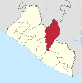
Nimba County is a county in northeastern Liberia that shares borders with the Republic of Côte d'Ivoire in the East and the Republic of Guinea in the Northwest. Its capital city is Sanniquellie and its most populous city is Ganta. With the county's area measuring 11,551 square kilometres (4,460 sq mi), Nimba is the largest of Liberia's 15 counties. The county has six statutory districts. As of the 2022 Census, it had a population of 621,841, making it the second most-populous county in Liberia.

Bomi is a county in the northwestern portion of the West African nation of Liberia. The county was established in 1984. The county's area is 746 square miles (1,900 km2).

Bong is a county in the north-central portion of the West African nation of Liberia. One of 15 counties that comprise the first-level of administrative division in the nation, it has twelve districts. Gbarnga serves as the capital. The area of the county measures 8,772 square kilometres (3,387 sq mi). As of the 2022 Census, it had a population of 467,502, making it the third-most populous county in Liberia. The county was organized in 1964 and is important for its mining industry.

Grand Gedeh is a county in the eastern portion of the West African nation of Liberia. One of 15 counties that constitute the first-level of administrative division in the nation, it has three districts. Zwedru serves as the capital with the area of the county. Measuring 10,484 square kilometres (4,048 sq mi), it is larger than 28 independent countries including Lebanon, Trinidad and Tobago, Cape Verde, Malta and Mauritius and the combined area of the US states of Delaware and Rhode Island. As of the 2022 Census, it had a population of 216,692, making it the 7th most populous county in Liberia. Grand Gedeh has lower tropical forests which has mid size hills composed of various valleys and water courses. These forests receive a very high rainfall ranging from 3,000 mm (120 in) to 4,100 mm (160 in) per year.

Grand Kru County is a county in the southeastern portion of Liberia. One of 15 counties that comprise the first-level of administrative division in the nation, it has eighteen districts. Organized in 1984, its capital is Barclayville. The area of the county measures 3,895 square kilometres (1,504 sq mi). As of the 2008 Census, it had a population of 109,342, making it the third-least populous county in Liberia.

Margibi is a county on the north to central coast of Liberia. One of 15 counties that constitute the first-level of administrative division in the nation, it has five districts. Kakata serves as the capital with the area of the county measuring 2,616 square kilometres (1,010 sq mi). As of the 2022 Census, it had a population of 304,946, making it the fith most populous county in Liberia.

Sinoe is one of Liberia's 15 counties and it has 17 districts. Greenville is the county's capital. As of the 2022 Census, it had a population of 150,358, making it one of the least populous counties in Liberia. Sinoe has the third-largest area of all Liberia's counties; it has the second least-dense population after Gbarpolu County. The County was originally a colony in the name Mississippi-in-Africa, under auspices of a chapter of the American Colonization Society as it was created with slaves from Mississippi to Liberia.

Zwedru is the capital of Grand Gedeh County, one of the 15 counties in Liberia. Zwedru is located in Tchien District of Grand Gedeh County, near the Cavalla River in the country's south-eastern region and near the border with Côte d'Ivoire. It is located 350 miles southeast from the capital city of Monrovia. The town is a stronghold of the Krahn tribe.

Fish Town is the capital city of River Gee County, Liberia. As of the 2008 national census, the population stood at 3,328.

Konobo District is one of three districts located in Grand Gedeh County, Liberia. The administrative seat of the District is Ziah Town. As of 2008, the District had 50,161 people making it the second most populated in Grand Gedeh County next to Gbarzon District. In area, it is about 1,400 square miles.
Glaro District is one of 10 districts of River Gee County, Liberia. As of 2008, the population was 4,992.

Rivercess County is a county in the south-central portion of the West African nation of Liberia. One of 15 counties that compose the first-level of administrative division in the nation, it has six districts. Cesstos City serves as the capital with the area of the county measuring 5,594 square kilometres (2,160 sq mi). As of the 2008 Census, it had a population of 71,509, making it the second least populous county in Liberia after Grand Kru County.

Agriculture in Liberia is a major sector of the country's economy worth 38.8% of GDP, employing more than 70% of the population and providing a valuable export for one of the world's least developed countries. Liberia has a climate favourable to farming, vast forests, and an abundance of water, yet low yields mean that over half of foodstuffs are imported, with net agricultural trade at -$73.12 million in 2010. This was dismissed as a "misconception" by Liberia's Minister of Agriculture.
Ziah Town was a small town in Grand Gedeh County in southeastern Liberia and serves as the administrative seat of Konobo District. Majority of the residents are ethnic Krahn and many use its language on a daily basis. it is a city now with about 3000 plus people living there from : konobo, Glio,Twabo putu and sometimes Glaro( the area used to be part of grand Gedeh county now River Gee)