Mayes County is a county located in the U.S. state of Oklahoma. As of the 2010 census, the population was 41,259. Its county seat is Pryor Creek. Named for Samuel Houston Mayes, Principal Chief of the Cherokee Nation from 1895 to 1899, it was originally created at the Sequoyah Convention in August 1905.

Monrovia is the capital city of the West African country of Liberia. Founded in 1822, it is located on Cape Mesurado on the Atlantic coast, and is the country's most populous city. As of the 2008 census, with 1,010,970 residents, it was home to 29% of Liberia’s total population. Monrovia is also the country’s economic, financial and cultural center. Its economy is primarily centered on its harbor and its role as the seat of Liberia's government.
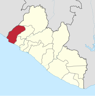
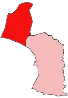
Grand Cape Mount is a county in the northwestern portion of the West African nation of Liberia. One of 15 counties that constitute the first-level of administrative division in the nation, it has five districts. Robertsport serves as the capital with the area of the county measuring 5,162 square kilometres (1,993 sq mi). As of the 2008 Census, it had a population of 129,817, making it the eighth most populous county in Liberia. The county is bordered by Gbarpolu County to the northeast and Bomi County to the southeast. The northern part of Grand Cape Mount borders the nation of Sierra Leone, while to the west lies the Atlantic Ocean.

Maryland County is a county in the southeastern portion of Liberia. One of 15 counties that comprise the first-level of administrative division in the nation, it has two districts. Harper serves as the capital with the area of the county measuring 2,297 square kilometres (887 sq mi). As of the 2008 Census, it had a population of 136,404, making it the seventh most populous county in Liberia.
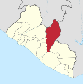
Nimba County is a county in northeastern Liberia that shares borders with the Republic of Côte d'Ivoire in the East and the Republic of Guinea in the Northwest. Its capital city is Sanniquellie and its most populous city is Ganta. With the county's area measuring 11,551 square kilometres (4,460 sq mi), Nimba is the largest of Liberia's 15 counties. The county has six statutory districts. As of the 2008 Census, it had a population of 462,026, making it the second most-populous county in Liberia.

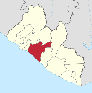
Bong is a county in the north-central portion of the West African nation of Liberia. One of 15 counties that comprise the first-level of administrative division in the nation, it has twelve districts. Gbarnga serves as the capital. The area of the county measures 8,772 square kilometres (3,387 sq mi). As of the 2008 Census, it had a population of 328,919, making it the third-most populous county in Liberia. The county was organized in 1964 and is important for its mining industry.
Grand Bassa is a county in the west-central portion of the West African nation of Liberia. One of 15 counties that comprise the first-level of administrative division in the nation, it has eight districts. Buchanan serves as the capital with the area of the county measuring 7,936 square kilometres (3,064 sq mi). As of the 2008 Census, it had a population of 224,839, making it the fifth most populous county in Liberia.

Grand Gedeh is a county in the eastern portion of the West African nation of Liberia. One of 15 counties that constitute the first-level of administrative division in the nation, it has three districts. Zwedru serves as the capital with the area of the county. Measuring 10,484 square kilometres (4,048 sq mi), it is larger than 28 independent countries including Lebanon, Trinidad and Tobago, Cape Verde, Malta and Mauritius and the combined area of the US states of Delaware and Rhode Island. As of the 2008 Census, it had a population of 126,146, making it the ninth most populous county in Liberia. Grand Gedeh has lower tropical forests which has mid size hills composed of various valleys and water courses. These forests receive a very high rainfall ranging from 3,000 mm (120 in) to 4,100 mm (160 in) per year.

Grand Kru County is a county in the southeastern portion of Liberia. One of 15 counties that comprise the first-level of administrative division in the nation, it has eighteen districts. Organized in 1984, its capital is Barclayville. The area of the county measures 3,895 square kilometres (1,504 sq mi). As of the 2008 Census, it had a population of 57,106, making it the least populous county in Liberia.

River Gee is a county in the southern portion of Liberia. One of 15 counties that constitute the first-level of administrative division in the nation, it has six districts. Fish Town serves as the capital with the area of the county measuring 5,113 square kilometres (1,974 sq mi). As of the 2008 Census, it had a population of 66,789, making it the third-least populous county in Liberia. It was created in 2000.

Barclayville is the capital and most populous settlement in Grand Kru County, located in southeastern Liberia about 10 miles inland from Picinicess. As of the 2008 national census, the population stood at 2,733. The Barclayville township straddles the banks of the Na River. Roads from Kanweaken to the northwest, Pleebo to the southeast, and to Picinicess and Grand Cess to the southeast, all intersect at Barclayville.

The House of Representatives is the lower chamber of the bicameral legislative branch of Liberia, and together with the Senate comprises the Legislature of Liberia. The number of seats is fixed by law at 73, with each county being apportioned a number of seats based on its percentage of the national population. House members represent single-member districts within the counties drawn up by the National Elections Commission and serve six-year terms. The House meets at the Capitol Building in Monrovia.
Zwedru is the capital of Grand Gedeh County, one of the 15 counties in Liberia. Zwedru is located in Tchien District of Grand Gedeh County, near the Cavalla River in the country's south-eastern region and near the border with Côte d'Ivoire. It is located 350 miles southeast from the capital city of Monrovia. The town is a stronghold of the Krahn tribe.

The Krumen is an ethnic group living mostly along the coast of Liberia and Côte d’Ivoire. Their numbers were estimated to be 48,300 in 1993, of which 28,300 were in Côte d’Ivoire. They are a subgroup of the Grebo and speak the Krumen language.

Konobo District is one of three districts located in Grand Gedeh County, Liberia. The administrative seat of the District is Ziah Town. As of 2008, the District had 50,161 people making it the second most populated in Grand Gedeh County next to Gbarzon District. In area, it is about 1,400 square miles.
Barrobo District is a district of Liberia, one of the three located in Maryland County.
Jabo is the self-designation of an ethnic group located in the southeastern part of the Republic of Liberia in West Africa. They have also sometimes referred to themselves as Gweabo or Nimiah tribe.

Grebo people is a term used to refer to an ethnic group or subgroup within the larger Kru group of Africa, a language and cultural ethnicity, and to certain of its constituent elements. Within Liberia members of this group are found primarily in Maryland County and Grand Kru County in the southeastern portion of the country, but also in River Gee County and Sinoe County. The Grebo population in Côte d'Ivoire are known as the Krumen and are found in the southwestern corner of that country.

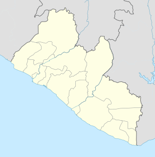
Liberia is divided into fifteen first-level administrative divisions called counties, which, in turn, are subdivided into a total of 90 second-level administrative divisions called districts and further subdivided into third-level administrative divisions called clans.
Plahn Nyarn District is one of 16 districts of Sinoe County, Liberia. As of 2008, the population was 6,805.