Plahn Nyarn District

Last updated

Plahn Nyarn District is one of the 16 districts in Sinoe County, Liberia. The district is named after the Plain tribe and had a population of 6,805 as of the year 2008. [1]

Contents

History of The Plain Tribe

According to Dr. P. Potter Pajibo, the Plain Tribe derives its origin from the Cavalla River (Jubu), which is in the eastern part of Sinoe County. It's descendants link with the Grebo tribe, because of which the tribe is usually referred to as Bush Grebo.

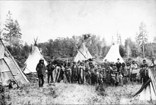
The continued rift between the Grebo tribe and the Plain tribe stirred up a series of inter-tribal wars, and the latter was forced to leave in search of a suitable place of abode under the leadership of Tarjuo, a doctor and warrior. The people of the Plain tribe travelled for months and at last reached a mountain, now called “Tarjuo Mountain” in honor of their leader Tarjuo. He is also the person after whom the Tarjuozon tribes are named where they decided to settle.

The decision to make Tarjuo Mountain their home was unanimous among the people of the Plain tribe. They settled and remained there for a few years until the death of Tarjuo.

When Tarjuo died, the Plain tribe people felt discouraged; and after a deep contemplation, decided to leave the Tarjuo Mountain. Because of their strong conviction in superstition, the tribal people found the mountain unsuitable to live, and felt that upon their failure to leave, they would suffer an untimely death.

Under the leadership of one of Tarjuo's sons, Plain, after whom the tribe is named, the group left the Tarjuo Mountain in search of another place for settlement. For months they travelled many miles and finally reached a certain creek, called “Slae-Nee” meaning Magic Creek. This was their final destination and settlement. Tribal legend has it that when they reached this area, a vision of a bright future was formed; previous conflicts and disturbances were decreased. They believed that this creek also greatly and surprisingly aided their tribe during a war between them and the Krahn people.

The main cause of the tribe's decision to settle around the Slae-Nee Creek was for protection. Since the organization and establishment of the Plain tribe, its people have been worshipping the Slae – Nee Creek as one of their tribal gods.

The following chiefs are said to have been some of the most outstanding and influential leaders of the tribe:

Jowiehfueh, Sworrfueh, Gbartieh Jarfue, Gborpannon, Gbarweh Nuon, Karjah, Dopaetron, Wiehkue and Kujah Sworrfueh.

Because of lack of written records, nothing much can be said about the contributions they made. However, it is said that they had ably conducted and protected the affairs of the tribe.

Since its establishment, there have been diverse kinds of tribal governments. Since there was no mentioned central government at the time, the tribesmen organized themselves into a strong body of local tribal government and elected Jowiehfueh as their first chief or king. He is said to have faithfully conducted the affairs of the tribe to the best of his ability and remained in power until his death.

Since the death of the first king Jowiehfueh, there has been a succession of others up to the present as listed below:

Paramount Chiefs: Pantonteh, Jarkue Wolloh, Teah-Deboe Pajibo, Wrogbo Jah, Weagbah, Tanneh Weah and Torteh.

Clan Chiefs: Pantonteh, Kietegbeh, Nyonuwion, Nyenfueh, Tanneh Weah – Plahn, Weagbah – Kulu, Pobleh – Nyarn, Pallaywion - Shoah, Tanneh Weah - Plahn, Torteh - Nyarn, Falleh – Puea - Kulu, Garsaylee Toryen– Buer – Shoah, David Pyne - Plahn, Torteh - Nyarn, Wionjuo - Kulu, Garsaylee Toryen– Buer -Shoah, Brown Nyenfueh – Plahn/Nyarn

Government

The tribe as a whole is divided into three main family groups comprising twelve subdivisions. The reasons for the divisions are due to repeated conflicts and dissatisfactions among the three distinct original families. They felt that this would enable them to multiply, expand and to build the tribe more effectively. They also wanted a separate and independent leadership for each division.

Below are the three original family groups and their subdivisions:

Plentarh Group: Chuoh, Sworrh, Kaetarh, Gedaquen

Snoh – Dea – Quen: Weorh, Tartouh, Wenjaoh, Saoh

Barlor – Quen : Chuoh,Swisslow, Tuon, Clayar – Quen

Legend suggests that all tribes were, from the beginning, wandering from place to place in search of suitable sites for settlements. The Plahn Tribe therefore did not come in contact with any tribal group in traveling from the Cavalla River area and Tarjuo Mountain.

Economy and Culture

The sum total of the attainments and activities – the culture and economy – of the tribe is the producing of wooden utensils such as spoons, and pans; clay pots for cooking and water buckets; the first clothing were made or obtained from bamboo limps, barks of trees, etc.; melted rocks to make cutlasses and spears; and the making of rattan baskets and chairs acquired from other neighboring tribes.

Religion

Their religious background was through their various tribal gods such as Slae – Nee Creek, the Rock Wiah, Kae – Gedoe – Plie, Nyanfurh, and Genopuarch. In the event of war with other tribe, a special selected group of the Plahn Tribe would go to these gods and make sacrifices. Their belief was that these gods would help avoid the war, and would make the tribe very wealthy and productive for abode.

Nowadays, most of these gods have been abandoned and replaced by Christianity. This is the result of colonialist missionary efforts affecting tribal culture and the inhabitants of the tribe.

Present Day

There is no record of the Plahn Tribe when engaged in conflict or war with the colonists or the pioneers who came from America. There has also been no war between the Plahn and the Sinoe tribes, known as Murrayville Settlement in Sinoe County. These two tribes have been very friendly since their settlement and were kind to the colonists.

Today, members of the Plahn Tribe from Tarjuozon District in Sinoe County can be found all over the globe. According to the latest census from the Liberian government, Plahn Nyarn District has a little over 428 inhabitants.

Related Research Articles

<span class="mw-page-title-main">Liberia</span> Country in West Africa

Liberia, officially the Republic of Liberia, is a country on the West African coast. It is bordered by Sierra Leone to its northwest, Guinea to its north, Ivory Coast to its east, and the Atlantic Ocean to its south and southwest. It has a population of around five and one-half million and covers an area of 43,000 square miles (111,369 km2). The country's official language is English; however, over 20 indigenous languages are spoken, reflecting the country's ethnic and cultural diversity. The capital and largest city is Monrovia.

<span class="mw-page-title-main">History of Liberia</span>

Liberia is a country in West Africa founded by free people of color from the United States. The emigration of African Americans, both freeborn and recently emancipated, was funded and organized by the American Colonization Society (ACS). The mortality rate of these settlers was the highest among settlements reported with modern recordkeeping. Of the 4,571 emigrants who arrived in Liberia between 1820 and 1843, only 1,819 survived (39.8%).

<span class="mw-page-title-main">Geography of Liberia</span>

Liberia is a sub-Saharan nation in West Africa located at 6 °N, 9 °W.

<span class="mw-page-title-main">Politics of Liberia</span>

The Politics of Liberia takes place in a framework of a presidential representative democratic republic modeled on the government of the United States, whereby the President is the head of state and head of government; unlike the United States, however, Liberia is a unitary state as opposed to a federation and has a pluriform multi-party system rather than the two-party system that characterizes US politics. Executive power is exercised by the government. Legislative power is vested in both the government and the two chambers of the legislature.

<span class="mw-page-title-main">Lakota people</span> Indigenous people of the Great Plains

The Lakota are a Native American people. Also known as the Teton Sioux, they are one of the three prominent subcultures of the Sioux people, with the Eastern Dakota (Santee) and Western Dakota (Wičhíyena). Their current lands are in North and South Dakota. They speak Lakȟótiyapi—the Lakota language, the westernmost of three closely related languages that belong to the Siouan language family.

The Krahn are an ethnic group of Liberia and Ivory Coast. This group belongs to the Kru language family and its people are sometimes referred to as the Wee, Guéré, Sapo, or Wobe. It is likely that Western contact with the Kru language is the primary reason for the development of these different names.

<span class="mw-page-title-main">Umpqua people</span>

The Umpqua people are an umbrella group of several distinct tribal entities of Native Americans of the Umpqua Basin in present-day south central Oregon in the United States. The area south of Roseburg is now known as the Umpqua Valley.

<span class="mw-page-title-main">Stʼatʼimc</span> Salishan ethnic group of British Columbia, Canada

The Stʼatʼimc, also known as the Lillooet, St̓át̓imc, Stl'atl'imx, etc., are an Interior Salish people located in the southern Coast Mountains and Fraser Canyon region of the Interior of the Canadian province of British Columbia.

<span class="mw-page-title-main">Kru people</span> Ethnic group in West Africa

The Kru, Krao, Kroo, or Krou are a West African ethnic group who are indigenous to western Ivory Coast and eastern Liberia. European and American writers often called Kru men who enlisted as sailors or mariners Krumen. They migrated and settled along various points of the West African coast, notably Freetown, Sierra Leone, but also the Ivorian and Nigerian coasts. The Kru-speaking people are a large ethnic group that is made up of several sub-ethnic groups in Liberia and Ivory Coast. In Liberia, there are 48 sub-sections of Kru tribes, including the Jlao Kru. These tribes include Bété, Bassa, Krumen, Guéré, Grebo, Klao/Krao, Dida, Krahn people and Jabo people.

<span class="mw-page-title-main">Kutenai</span> Ethnic group; an indigenous people of Canada and the US

The Kutenai, also known as the Ktunaxa, Ksanka, Kootenay and Kootenai, are an indigenous people of Canada and the United States. Kutenai bands live in southeastern British Columbia, northern Idaho, and western Montana. The Kutenai language is a language isolate, thus unrelated to the languages of neighboring peoples or any other known language.

<span class="mw-page-title-main">Nimba County</span> County of Liberia

Nimba County is a county in northeastern Liberia that shares borders with the Republic of Côte d'Ivoire in the East and the Republic of Guinea in the Northwest. Its capital city is Sanniquellie and its most populous city is Ganta. With the county's area measuring 11,551 square miles (29,920 km2), Nimba is the largest of Liberia's 15 counties. The county has six statutory districts. As of the 2022 Census, it had a population of 621,841, making it the second most populous county in Liberia.

<span class="mw-page-title-main">Sinoe County</span> County in Liberia

Sinoe is one of Liberia's 15 counties and it has 17 districts. Greenville is the county's capital. As of the 2022 Census, it had a population of 150,358, making it one of the least populous counties in Liberia. Sinoe has the third-largest area of all Liberia's counties; it has the second least-dense population after Gbarpolu County. The County was originally a colony in the name Mississippi-in-Africa, under auspices of a chapter of the American Colonization Society as it was created with slaves from Mississippi to Liberia.

<span class="mw-page-title-main">River Gee County</span> County of Liberia

River Gee is a county in the southern portion of Liberia. One of 15 counties that constitute the first-level of administrative division in the nation, it has six districts. Fish Town serves as the capital with the area of the county measuring 1,974 square miles (5,110 km2). As of the 2022 Census, it had a population of 124,653, making it one of the least populous counties in Liberia. It was created in 2000.

<span class="mw-page-title-main">Zwedru</span> Place in Grand Gedeh County, Liberia

Zwedru is the capital of Grand Gedeh County, one of the 15 counties in Liberia. Zwedru is located in Tchien District of Grand Gedeh County, near the Cavalla River in the country's south-eastern region and near the border with Côte d'Ivoire. It is located 350 miles southeast from the capital city of Monrovia. The town is a stronghold of the Krahn tribe.

<span class="mw-page-title-main">Barrobo District</span> District of Liberia

Barrobo District is a district of Liberia, one of the three located in Maryland County.

<span class="mw-page-title-main">Joseph James Cheeseman</span> Former President of Liberia

Joseph James Cheeseman was the 12th president of Liberia. Born at Edina in Grand Bassa County, he was elected three times on the True Whig ticket. Cheeseman was educated at Liberia College.

Jabo is the self-designation of an ethnic group located in the southeastern part of the Republic of Liberia in West Africa. They have also sometimes referred to themselves as Gweabo or Nimiah tribe.

<span class="mw-page-title-main">Grebo people</span> Ethnic group in West Africa

The Grebo or Glebo people are an ethnic group or subgroup within the larger Kru group of Africa, a language and cultural ethnicity, and to certain of its constituent elements. Within Liberia members of this group are found primarily in Maryland County and Grand Kru County in the southeastern portion of the country, but also in River Gee County and Sinoe County. The Grebo population in Côte d'Ivoire are known as the Krumen and are found in the southwestern corner of that country.

<span class="mw-page-title-main">New Georgia, Liberia</span>

New Georgia is a township in Montserrado County, Liberia that was first settled by Africans who had been taken from slave ships seized or wrecked near the United States and then sent to Liberia after several years had passed.

<span class="mw-page-title-main">Ivory Coast expedition</span>

The Ivory Coast expedition, or the Liberia expedition, was a naval operation in 1842, launched by the United States against the West African Bereby people. After the attacks on the merchant ships Mary Carver and Edward Barley, the American Congress approved a punitive expedition to the area and placed Commodore Matthew C. Perry in command. The expedition was successful in exacting redress by destroying the fortified town of Little Bereby and by killing the chief responsible for the attacks on American shipping.

References

  1. "2008 National Population and Housing Census: Preliminary Results" (PDF). Government of the Republic of Liberia. 2008. p. 18. Retrieved 2009-11-30.

5°18′22″N9°02′02″W / 5.306°N 9.034°W / 5.306; -9.034