
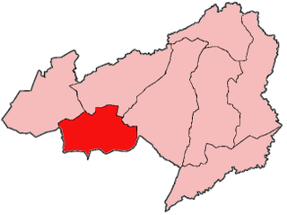
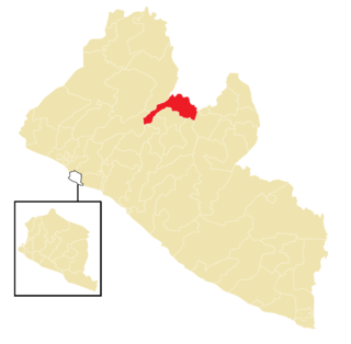
Panta-Kpa District is one of twelve districts located in Bong County, Liberia. It has four third-level subdivisions: Wrunah, Panta, Waytua, and Wolota. [1]
Panta-Kpa District is one of twelve districts located in Bong County, Liberia. It has four third-level subdivisions: Wrunah, Panta, Waytua, and Wolota. [1]

Liberia, officially the Republic of Liberia, is a country on the West African coast. It is bordered by Sierra Leone to its northwest, Guinea to its north, Ivory Coast to its east, and the Atlantic Ocean to its south and southwest. It has a population of around 5.5 million and covers an area of 43,000 square miles (111,369 km2). The official language is English. Over 20 indigenous languages are spoken, reflecting the country's ethnic and cultural diversity. The capital and largest city is Monrovia.

Monrovia is the capital and largest city of Liberia. Founded in 1822, it is located on Cape Mesurado on the Atlantic coast and as of the 2022 census had 1,761,032 residents, home to 33.5% of Liberia’s total population. Its Metro Area including Montserrado and Margibi counties largely being urbanized, was home to 2,225,911 inhabitants as of the 2022 census. As the nation's primate city, Monrovia is the country's economic, financial and cultural center; its economy is primarily centered on its harbor and its role as the seat of Liberian government.

Montserrado County is a county in the northwestern portion of the West African nation of Liberia containing its national capital, Monrovia. One of 15 counties that comprise the first-level of administrative division in the nation, it has 17 sub political districts. As of the 2022 Census, it had a population of 1,920,914, making it the most populous county in Liberia. The area of the county measures 738.5 square miles (1,913 km2), the smallest in the country. Bensonville serves as the capital.

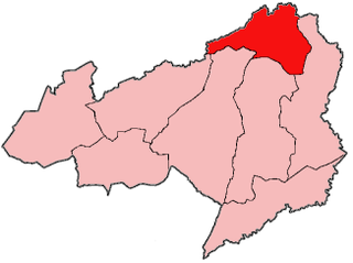
Bong is a county in the north-central portion of the West African nation of Liberia. One of 15 counties that comprise the first-level of administrative division in the nation, it has twelve districts. Gbarnga serves as the capital. The area of the county measures 8,772 square kilometres (3,387 sq mi). As of the 2022 Census, it had a population of 467,502, making it the third-most populous county in Liberia. The county was organized in 1964 and is important for its mining industry.

Fuamah District is one of twelve districts located in Bong County, Liberia. it has five third level subdivisions Lorlah,Zuluzaryea,Yarbayon,Bubli and,Zarwakuma

Jorquelleh District is one of twelve districts of Bong County, Liberia.It has five third level subdivisions Jorpoo,Bellequelleh,Jorquelle,Gbarnshay, andSheansuie
Salala District is one of twelve districts in Bong County, Liberia. Multiple internally displaced person camps are located in the district.It has four third level subdivisions Konoyea,Konowulala,Nyanforquelleh,Kpartolor

Sanayea District is one of twelve districts located in Bong County, Liberia.It has six third level sub divisions Menquelleh,Wallahun,Deingmah,Boryermah,Sanoyea,Bonkomu
Zota District is one of twelve districts located in Bong County, Liberia.It has four third level subdivisions Upper Kpaquelleh,Zota,Lower Kpaquelleh,andGwilapolu

The Kokoyah Administrative District is one of twelve districts located in Bong County, Liberia.It has four third level subdivisions Bonwein,Senwein,Tukpablee, and Kokoyah
Yinmabin is a town and seat of the Yinmabin Township in the Sagaing Division in central Myanmar some 100 kilometres (62 mi) west of Mandalay.

Panta Bhat or Poita Bhat consists of cooked rice soaked and fermented in water. The liquid part is known as Toraṇi. It is a rice-based dish prepared by soaking rice, generally leftover, in water overnight. Traditionally served in the morning with salt, onion, chili and mashed potatoes or "Alu Makha". It is consumed in eastern Indian states of West Bengal, Odisha (Pakhala), Jharkhand, Chhattisgarh, Assam, Tripura and in the country of Bangladesh. Panta Bhat with Ilish (Hilsha) is the National Dish of Bangladesh. It is a popular dish on the day of Pahela Baishakh or Bengali new year. It has been described in documents from 17th century. Panta bhat has more micronutrients than fresh rice. It is traditionally considered as beneficial in conditions.

Saint-Pantaly-d'Excideuil is a commune in the Dordogne department in Nouvelle-Aquitaine in the southwestern part of France.

Liberia is divided into fifteen first-level administrative divisions called counties, which, in turn, are subdivided into a total of 90 second-level administrative divisions called districts and further subdivided into third-level administrative divisions called clans.
Great American Dream Machines is a series of model cars. The series consists of 1:43 white-metal models of mid-20th century Detroit showcars, handbuilt in the U.K. by SMTS.

GADM, the Database of Global Administrative Areas, is a high-resolution database of country administrative areas, with a goal of "all countries, at all levels, at any time period." Although it is a public database, GADM has a higher spatial resolution than other free databases, and also higher than commercial software such as ArcGIS. Those sources are commonly use to complete data analysis with data visualisation such as data plots, choropleth map, etc.
Panta Rhei is a video game engine developed by Capcom, for use with 8th generation consoles PlayStation 4, Xbox One; as a replacement for its previous MT Framework engine.

Jorge Brian Panta Herreros is a Peruvian tennis player.

Tongaren is an electoral constituency in Kenya. Tongaren constituency politically came into existence in 2012 prior to the 2013 general election. The constituency was carved off from the then larger Kimilili Constituency. It is one of the 290 constituencies in Kenya and one of the 9 constituencies in Bungoma County. The Independent Electoral and Boundaries Commission (IEBC) registered 84,952 voters in Tongaren constituency for the August 9th 2022 general election in Kenya.
Bong-4 is an electoral district for the elections to the House of Representatives of Liberia. The constituency covers Panta District, nine communities of Zota District and three communities of Sanoyea District.
| | This Liberia location article is a stub. You can help Wikipedia by expanding it. |