
Lofa is a county in the northernmost portion of Liberia. One of 15 counties that constitute the first-level of administrative division in the nation, it has nine districts. Voinjama serves as the capital with the area of the county measuring 9,982 square kilometres (3,854 sq mi). As of the 2008 Census, it had a population of 276,863, making it the third most populous county in Liberia.
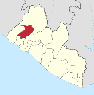
Gbarpolu is a county in the northern portion of Liberia. One of 15 counties that comprise the first-level of administrative division in the nation, it has six districts. Bopulu serves as the capital with the area of the county measuring 9,689 square kilometres (3,741 sq mi). As of the 2008 Census, it had a population of 83,758, making it the eleventh-most populous county in Liberia.

Bomi is a county in the northwestern portion of the West African nation of Liberia. The county was established in 1984. The county's area is 746 square miles (1,900 km2).

Bong is a county in the north-central portion of the West African nation of Liberia. One of 15 counties that comprise the first-level of administrative division in the nation, it has twelve districts. Gbarnga serves as the capital. The area of the county measures 8,772 square kilometres (3,387 sq mi). As of the 2008 Census, it had a population of 328,919, making it the third-most populous county in Liberia. The county was organized in 1964 and is important for its mining industry.
Armah Zolu Jallah is a Liberian politician and member of the National Patriotic Party (NPP). Senator Armah Zolu Jallah replaced Cllr. Eddington Varmah in the Senate in 1998 as Senator of Lofa County in a by-election he won by about 70%. The creation of Gbarpolu was the result of a pledge he made in the by-election to replace Eddington Varmah. He mobilized the people of Gbarma and Bopolu Statutory Districts for this purpose. He attended both the Gbarma and Bopolu meetings that initiated plans for the creation of Gbarpolu County during the Taylor administration.

The Eastern Province is one of the four provinces of Sierra Leone. It covers an area of 15,553 km² and has a population of 1,641,012. Its capital and administrative centre is Kenema. Eastern Province, the centre of the country's diamond mining industry, is very mountainous and has two ranges, the Gola Hills and the Loma Mountains.

The House of Representatives is the lower chamber of the bicameral legislative branch of Liberia, and together with the Senate comprises the Legislature of Liberia. The number of seats is fixed by law at 73, with each county being apportioned a number of seats based on its percentage of the national population. House members represent single-member districts within the counties drawn up by the National Elections Commission and serve six-year terms. The House meets at the Capitol Building in Monrovia.

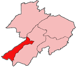
Bopolu District is one of five districts located in Gbarpolu County, Liberia.

Bokomu District is one of five districts located in Gbarpolu County, Liberia.
Gbarma District is one of five districts located in Gbarpolu County, Liberia.

Kongba District is one of five second-level administrative divisions located in Gbarpolu County, Liberia.

Foya District is one of six districts located in Lofa County, Liberia. Foya District is the most populous district in Lofa County, with a population of 73,312 people as of the 2008 census. Foya is predominantly occupied by the Kissi tribe. Foya is about 450 km (280 mi) from Monrovia.

Kolahun District is the largest administrative district of Lofa County in Liberia. It has an estimated population of 59,057. Kolahun was the scene of heavy fighting between government troops and rebels during Liberia's second civil war, causing massive shifts in population and destruction of property.

Salayea District is one of six districts located in Lofa County, Liberia.

Vahun District is one of six districts located in Lofa County, Liberia.

Zorzor District is one of six districts located in Lofa County, Liberia. Zorzor is principal city of the county.

Voinjama District is one of six districts located in Lofa County, Liberia.

Liberia is divided into fifteen first-level administrative divisions called counties, which, in turn, are subdivided into a total of 90 second-level administrative divisions called districts and further subdivided into third-level administrative divisions called clans.
Gola is a language of Liberia and Sierra Leone. It was traditionally classified as an Atlantic language, but this is no longer accepted in more recent studies.
