Chicola

Last updated

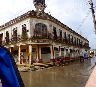
Chicola was a small port on the north coast of the Fallas, Cuba. It was built in 1932 by the Fallas-Gutiérrez sugar company to ship to the US the sugar produced by the factories of Central Patria and Central Adelaida. It is located on a bay in front of Cayo Coco island, near the Laguna de Leche, at c. 30 km north-west of Morón, Ciego de Ávila Province. [1]

Cuba Country in the Caribbean

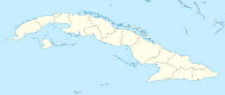
Cuba, officially the Republic of Cuba, is a country comprising the island of Cuba as well as Isla de la Juventud and several minor archipelagos. Cuba is located in the northern Caribbean where the Caribbean Sea, Gulf of Mexico and Atlantic Ocean meet. It is east of the Yucatán Peninsula (Mexico), south of both the U.S. state of Florida and the Bahamas, west of Haiti and north of both Jamaica and the Cayman Islands. Havana is the largest city and capital; other major cities include Santiago de Cuba and Camagüey. The area of the Republic of Cuba is 110,860 square kilometres (42,800 sq mi). The island of Cuba is the largest island in Cuba and in the Caribbean, with an area of 105,006 square kilometres (40,543 sq mi), and the second-most populous after Hispaniola, with over 11 million inhabitants.

United States federal republic in North America

The United States of America (USA), commonly known as the United States or America, is a country composed of 50 states, a federal district, five major self-governing territories, and various possessions. At 3.8 million square miles, the United States is the world's third or fourth largest country by total area and is slightly smaller than the entire continent of Europe's 3.9 million square miles. With a population of over 327 million people, the U.S. is the third most populous country. The capital is Washington, D.C., and the largest city by population is New York City. Forty-eight states and the capital's federal district are contiguous in North America between Canada and Mexico. The State of Alaska is in the northwest corner of North America, bordered by Canada to the east and across the Bering Strait from Russia to the west. The State of Hawaii is an archipelago in the mid-Pacific Ocean. The U.S. territories are scattered about the Pacific Ocean and the Caribbean Sea, stretching across nine official time zones. The extremely diverse geography, climate, and wildlife of the United States make it one of the world's 17 megadiverse countries.

Cayo Coco Resort island and village in Ciego de Ávila, Cuba

Cayo Coco is an island in central Cuba, known for its all-inclusive resorts. It lies within the Ciego de Ávila Province and is part of a chain of islands called Jardines del Rey. The cay is administered by the Morón municipality, has a surface area of 370 km2, and is named after the white ibis, locally called coco (coconut) birds. The island is known for its long beaches and many resort hotels.

History

The name came from the Spanish word (chico), which means "small" or "tight". The only access to Chicola was through 9 kilometers of railroad that ran, from Falla, on a heavily forested and swampy terrain. The sugar was carried in railroad wagons and then loaded onto flat-bottom boats to be taken over 25 miles of shallow sea (6 feet) to deep ocean, (Cayo Guillermo), where it was transferred to big liners. It operated until 1968. In 1962 the Cuban coast guard installed a station with a 100-foot-high watchtower, which was closed in 1975. Today it is an abandoned locality visited only by fishermen. The railways were salvaged for materials for cattle fence construction.

Spanish language Romance language

Spanish or Castilian is a Western Romance language that originated in the Castile region of Spain and today has hundreds of millions of native speakers in the Americas and Spain. It is a global language and the world's second-most spoken native language, after Mandarin Chinese.

Rail transport Conveyance of passengers and goods by way of wheeled vehicles running on rail tracks

Rail transport is a means of transferring of passengers and goods on wheeled vehicles running on rails, also known as tracks. It is also commonly referred to as train transport. In contrast to road transport, where vehicles run on a prepared flat surface, rail vehicles are directionally guided by the tracks on which they run. Tracks usually consist of steel rails, installed on ties (sleepers) and ballast, on which the rolling stock, usually fitted with metal wheels, moves. Other variations are also possible, such as slab track, where the rails are fastened to a concrete foundation resting on a prepared subsurface.

Falla (Chambas) Village in Ciego de Ávila, Cuba

Falla is a Cuban village and consejo popular of the municipality of Chambas, in Ciego de Ávila Province. In 2011 it had a population of about 8,789.

Related Research Articles

La Habana Province Province in Cuba

Havana Province was one of the provinces of Cuba, prior to being divided into two new provinces of Artemisa and Mayabeque on January 1, 2011. It had 711,066 people in the 2002 census. The largest city was Artemisa (81,209).

Villa Clara Province Province of Cuba

Villa Clara is one of the provinces of Cuba. It is located in the central region of the island bordering with the Atlantic at north, Matanzas Province by west, Sancti Spiritus Province by east, and Cienfuegos Province on the South. Villa Clara shares with Cienfuegos and Sancti Spiritus on the south the Escambray Mountain Range. Its main cities are Santa Clara, Remedios, Sagua La Grande, Camajuani, Caibarién, Ranchuelo, Placetas, and Manicaragua.

Ciego de Ávila Province Province of Cuba

Ciego de Ávila is one of the provinces of Cuba, and was previously part of Camagüey Province. Its capital is Ciego de Ávila, which lies on the Carretera Central, and the second city is Morón, further north.

Caibarién Municipality in Villa Clara, Cuba

Caibarién is a municipality city in the Villa Clara province of Cuba.

Nuevitas Municipality in Camagüey, Cuba

Nuevitas is a municipality and port town in the Camagüey Province of Cuba. The large bay was sighted by Christopher Columbus in 1492.

Chambas Municipality in Ciego de Ávila, Cuba

Chambas is a municipality and town in the Ciego de Ávila Province of Cuba.

Morón, Cuba Municipality in Ciego de Ávila, Cuba

Morón is a city and a municipality in Ciego de Ávila Province in central Cuba. It is one of ten municipalities in the province, and is the second in importance and the oldest. Morón is the closest city to the tourist resorts on Cayo Coco and Cayo Guillermo.

Jardines de la Reina protected area

Jardines de la Reina is an archipelago in the southern part of Cuba, in the provinces of Camagüey and Ciego de Ávila.

Cayo Romano

Cayo Romano is an island on the northern coast of Cuba, in the province of Camagüey. It is the largest cay of the Jardines del Rey archipelago with 777 square kilometres (300 sq mi).

Cayo Sabinal human settlement

Cayo Sabinal is a cay on the northern coast of Cuba, in the municipality of Nuevitas, Camagüey Province. Has an area of 335 km².

Remedios, Cuba Municipality in Villa Clara, Cuba

Remedios, also known as San Juan de los Remedios, is a city and municipality located 3 miles (4.8 km) from the northern coast of Cuba, in the center of the island. It is the oldest Spanish settlement in the former Las Villas province. It is now part of the province of Villa Clara. It was declared a City by Isabella II of Spain, when the Island was still a colony. Remedios is the Cradle of the Parrandas, possibly the Caribbean's largest and oldest traditional festivity. Its patrons are San Juan Bautista and the Virgin of the Buenviaje.

Cay Sal Bank Carbonate platform in Bahama Banks, The Bahamas

Cay Sal Bank is the third largest and the westernmost of the Bahama Banks. It is located between 23º27'N - 24º10'N and 079º25'W – 080º35'W. In a geographical sense, it is separate from the Bahamas proper as it is much closer to Cuba than to the closest Bahamanian island. It is separated by Santaren Channel from the Great Bahama Bank, the western rim of which is 50 km (31 mi) to the east. The Straits of Florida separate it from the United States mainland and the Florida Keys.

Kilo 9 Village in Ciego de Ávila, Cuba

Kilo 9 is a village in the Ciego de Ávila Province of Cuba part of the municipality of Chambas.

Jardines del Rey archipelago

Jardines del Rey is an archipelago off the northern coast of Cuba, in the northern parts of the provinces of Ciego de Ávila and Camagüey.

Bay of Buena Vista

The Bay of Buena Vista is a bay on Cuba's northern Atlantic shore. It is located in the northern part of the provinces of Sancti Spíritus, Villa Clara and Ciego de Ávila, between mainland Cuba and the archipelago that lines its northern coast.

Laguna de Leche lake

Laguna de Leche is the largest natural fresh water lake in Cuba. It is located in the wetland of northern Ciego de Ávila Province, 5 km (3.1 mi) north of Morón, and has a total surface of 67.2 square kilometres (25.9 sq mi).

Sabana-Camagüey Archipelago

Sabana-Camagüey is an archipelago that lines Cuba's north-central Atlantic coast. It is located off the northern coast of the provinces of Matanzas, Villa Clara, Sancti Spíritus, Ciego de Ávila and Camagüey, and is bounded to the north by the Atlantic Ocean, specifically by the Nicholas Channel and Old Bahama Channel.

Colorados Archipelago archipelago in Pinar del Río Province, Cuba

The Colorados Archipelago is a chain of isles and cays on Cuba's north-western coast.

Elbow Cays Cays in The Bahamas

The Elbow Cays are uninhabited cays in the Cay Sal Bank, Bahamas. They are part of a reef shelf located at the northwestern end of the bank about 80 km off the Cuban coast and 130 km southeast of Key West, Florida. These cays are an excellent scuba diving spot.

References

Coordinates: 22°18′7.2″N78°43′26.4″W / 22.302000°N 78.724000°W / 22.302000; -78.724000

Geographic coordinate system Coordinate system

A geographic coordinate system is a coordinate system that enables every location on Earth to be specified by a set of numbers, letters or symbols. The coordinates are often chosen such that one of the numbers represents a vertical position and two or three of the numbers represent a horizontal position; alternatively, a geographic position may be expressed in a combined three-dimensional Cartesian vector. A common choice of coordinates is latitude, longitude and elevation. To specify a location on a plane requires a map projection.