"},"area_total_km2":{"wt":"6946.90"},"area_land_km2":{"wt":""},"area_water_km2":{"wt":""},"area_water_percent":{"wt":""},"area_note":{"wt":""},"elevation_footnotes":{"wt":""},"elevation_m":{"wt":""},"elevation_max_m":{"wt":""},"population_footnotes":{"wt":"{{cite web|title=Lugar que ocupa el territorio según la superficie y la población|url=http://www.one.cu/publicaciones/08informacion/2010unamiradaacuba/03Cuba.pdf|work=Una MIRADA a Cuba|publisher=Oficina Nacional de Estadísticas. Cuba|language=es|year=2010|access-date=2012-01-15|archive-date=2019-03-11|archive-url=https://web.archive.org/web/20190311181658/http://www.one.cu/publicaciones/08informacion/2010unamiradaacuba/03Cuba.pdf|url-status=dead}}"},"population_total":{"wt":"503353"},"population_as_of":{"wt":""},"population_density_km2":{"wt":"auto"},"population_demonym":{"wt":""},"population_note":{"wt":""},"blank_name_sec2":{"wt":"[[Human Development Index|HDI]] (2019)"},"blank_info_sec2":{"wt":"0.784{{cite web|url=https://hdi.globaldatalab.org/areadata/shdi/|title=Sub-national HDI - Area Database - Global Data Lab|website=hdi.globaldatalab.org|language=en|access-date=2018-09-13}}
{{color|#0c0|high}} · [[List of Cuban provinces by Human Development Index|7th of 16]]"},"timezone1":{"wt":"[[Eastern Time Zone (North America)|EST]]"},"utc_offset1":{"wt":"-5"},"timezone1_DST":{"wt":""},"utc_offset1_DST":{"wt":""},"postal_code_type":{"wt":""},"postal_code":{"wt":""},"area_code_type":{"wt":""},"area_code":{"wt":""},"iso_code":{"wt":""},"website":{"wt":"https://www.ciegodeavila.gob.cu/es/"},"footnotes":{"wt":""},"official_name":{"wt":"Ciego de Ávila Province"},"image_flag":{"wt":""},"population_urban":{"wt":"430616"},"population_rural":{"wt":"72737"}},"i":0}}]}" id="mwBA">Province in Cuba
Ciego de Ávila Provincia de Ciego de Ávila | |
---|---|
Ciego de Ávila Province | |
![]() Ciego de Ávila's location in the Island of Cuba | |
Country | Cuba |
Settled | March 5, 1558 |
Capital | Ciego de Ávila |
Area | |
• Province | 6,946.90 km2 (2,682.21 sq mi) |
Population | |
• Province | 503,353 |
• Density | 72/km2 (190/sq mi) |
• Urban | 430,616 |
• Rural | 72,737 |
Time zone | UTC-5 (EST) |
HDI (2019) | 0.784 [2] high · 7th of 16 |
Website | https://www.ciegodeavila.gob.cu/es/ |
Ciego de Ávila (Spanish pronunciation: [ˈsjeɣoðeˈaβila] ) is one of the provinces of Cuba, and was previously part of Camagüey Province. Its capital is Ciego de Ávila, which lies on the Carretera Central (central highway), and the second city is Morón, further north.
The province was separated from Camagüey Province in 1976 by the government.
Off the north coast of the province, some (cays) of the Jardines del Rey archipelago are being developed as tourist resorts, principally Cayo Coco and Cayo Guillermo. The south coast is characterised by mangroves.
Between Morón and the north coast are several lakes, including the Laguna de Leche (the Lagoon of Milk, so called for its white appearance because of large lime deposits underwater) which is the largest natural lake in Cuba.
Central Ciego de Ávila is used for cattle ranching, elsewhere in the province sugar, pineapples and citrus fruit are grown. Pineapples are the staple crop, but sweet potatoes, potatoes, yuca, plantains, and bananas are also cultivated for national consumption.
Municipality | Population (2004) | Area (km2) | Location | Remarks |
---|---|---|---|---|
Baraguá | 32,408 | 728 | 21°40′56″N78°37′28″W / 21.68222°N 78.62444°W | includes Gaspar |
Bolivia | 16,612 | 918 | 22°04′30″N78°21′1″W / 22.07500°N 78.35028°W | |
Chambas | 39,868 | 769 | 22°11′48″N78°54′47″W / 22.19667°N 78.91306°W | |
Ciego de Ávila | 135,736 | 445 | 21°50′53″N78°45′46″W / 21.84806°N 78.76278°W | Provincial capital |
Ciro Redondo | 29,560 | 588 | 22°01′8″N78°42′10″W / 22.01889°N 78.70278°W | |
Florencia | 19,811 | 286 | 22°08′51″N78°58′1″W / 22.14750°N 78.96694°W | |
Majagua | 26,617 | 544 | 21°55′28″N78°59′26″W / 21.92444°N 78.99056°W | |
Morón | 60,612 | 615 | 22°06′39″N78°37′40″W / 22.11083°N 78.62778°W | includes Cayo Coco |
Primero de Enero | 27,813 | 713 | 21°56′43″N78°25′8″W / 21.94528°N 78.41889°W | |
Venezuela | 27,333 | 716 | 21°45′4″N78°46′44″W / 21.75111°N 78.77889°W |
Source: Population from 2004 Census. [3] Area from 1976 municipal re-distribution. [4]
In 2004, the province of Ciego de Ávila had a population of 416,370. [3] With a total area of 6,783.13 km2 (2,618.98 sq mi), [5] the province had a population density of 61.4/km2 (159/sq mi).
Santiago de Cuba Province is the second most populated province in the island of Cuba. The largest city Santiago de Cuba is the main administrative center. Other large cities include Palma Soriano, Contramaestre, San Luis and Songo-La Maya.
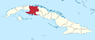
Villa Clara is one of the provinces of Cuba. It is located in the central region of the island bordering on the Atlantic Ocean to the north, Matanzas Province to the west, Sancti Spiritus Province to the east, and Cienfuegos Province to the South. Villa Clara shares with Cienfuegos and Sancti Spiritus on the south the Escambray Mountain Range. Its main cities are Santa Clara, Remedios, Sagua La Grande, Camajuani, Caibarién, Ranchuelo, Placetas, and Manicaragua.
The Pinar del Río Province is one of the 15 provinces of Cuba. It is at the western end of the island of Cuba. The capital and largest city is Pinar del Río.
Matanzas is one of the provinces of Cuba. Major towns in the province include Cárdenas, Colón, Jovellanos and the capital of the same name, Matanzas. The resort town of Varadero is also located in this province.
Cienfuegos is one of the provinces of Cuba. The capital city of the province is also called Cienfuegos and was founded by French settlers in 1819.
Sancti Spíritus is one of the provinces of Cuba. Its capital is the identically named Sancti Spíritus. Another major city is Trinidad.
Camagüey is the largest of the provinces of Cuba. Its capital is Camagüey. Other towns include Florida and Nuevitas.
Las Tunas is one of the provinces of Cuba. Major towns include Puerto Padre, Amancio, and the capital city, Las Tunas.
Holguín is one of the provinces of Cuba, the third most populous after Havana and Santiago de Cuba. It lies in the southeast of the country. Its major cities include Holguín, Banes, Antilla, Mayarí, and Moa.
Ciego de Ávila is a city in the central part of Cuba and the capital of Ciego de Ávila Province. The capital city has a population of about 156,322 and the province 430,507.
Manzanillo is a municipality and city in the Granma Province of Cuba. By population, it is the 14th-largest Cuban city and the most populated one not being a provincial seat.
Nuevitas is a municipality and port town in the Camagüey Province of Cuba. The large bay was sighted by Christopher Columbus in 1492.
Morón is a city and a municipality in Ciego de Ávila Province in central Cuba. It is one of ten municipalities in the province, and is the second in importance and the oldest. Morón is the closest city to the tourist resorts on Cayo Coco and Cayo Guillermo.
Jardines de la Reina is an archipelago in the southern part of Cuba, in the provinces of Camagüey and Ciego de Ávila.
Cayo Romano is an island on the northern coast of Cuba, in the province of Camagüey. It is the largest cay of the Jardines del Rey archipelago with 777 square kilometres (300 sq mi).
The provinces of Cuba are divided into 168 municipalities. They were defined by Cuban Law Number 1304 of July 3, 1976 and reformed in 2010 with the abrogation of the municipality of Varadero and the creation of two new provinces: Artemisa and Mayabeque in place of former La Habana Province.
Florencia is a municipality and town in the Ciego de Ávila Province of Cuba. It is located in the western part of the province, south of Chambas. This municipality merged in 1976 as a result of the new political and administrative division of Cuba. Florencia was formerly the barrios of Guadalupe, Tamarindo and Marroquí which were separated from the municipality of Morón.
Primero de Enero is a municipality and town in the Ciego de Ávila Province, Cuba. Originally named Violeta,¿ its name means "1st of January" in Spanish, and is referred to the final day of the Cuban Revolution. It is geographically located in the Northeast of the Province of Ciego de Ávila and has an extension of 712.7 km.
The Bay of Buena Vista is a bay on Cuba's northern Atlantic shore. It is located in the northern part of the provinces of Sancti Spíritus, Villa Clara and Ciego de Ávila, between mainland Cuba and the archipelago that lines its northern coast.
Sabana-Camagüey is an archipelago that lies on Cuba's north-central Atlantic coast. It is located off the northern coast of the provinces of Matanzas, Villa Clara, Sancti Spíritus, Ciego de Ávila and Camagüey, and is bounded to the north by the Atlantic Ocean, specifically by the Nicholas Channel and Old Bahama Channel.