Carretera Central (Cuba)

Last updated
Carretera Central (CC)
Central Road
Carretera Central map (Cuba).png
Route information
Length1,435 km (892 mi)
Existed1927–present
Major junctions
West end La Fé (Pinar del Río Province)
East end Baracoa (Guantánamo Province)
Location
Country Cuba
Major cities La Fé, Sandino, Pinar del Río, Artemisa, Havana, San José de las Lajas, Matanzas, Colón, Santa Clara, Placetas, Sancti Spíritus, Ciego de Ávila, Florida, Camagüey, Las Tunas, Holguín, Bayamo, Palma Soriano, Santiago de Cuba, Guantánamo, Baracoa
Highway system

The Carretera Central (CC), meaning "Central Road", is a west-east highway spanning the length of the island of Cuba.

Contents

History

Formal construction began in 1927 during the Gerardo Machado administration. [1] It runs along the island of Cuba from west to east, between Pinar del Río and Oriente. It is a two-way single road. It represented an extraordinary economic value during Machado and Fulgencio Batista's administrations. It facilitated faster transportation and effective inter-province commuting.

Route

Description

The Carretera Central starts in the village of La Fe, a hamlet of Sandino, in the western province of Pinar del Río, and links all major cities and province capitals except Cienfuegos. [2] It runs about 1,250 km (777 mi) [3] to Baracoa in the eastern Guantánamo province.

Table

The table below shows the route of the Carretera Central. [2] Note: Provincial seats are shown in bold; the names shown under brackets in the section "Municipality" indicate the municipal seats.

SettlementMunicipalityProvince
La Fe Sandino Pinar del Río
Sandino (Sandino)Pinar del Río
San Julián Sandino Pinar del Río
Isabel Rubio Guane Pinar del Río
Sábalo Guane Pinar del Río
San Juan y Martínez (San Juan y Martínez)Pinar del Río
Río Seco San Juan y Martínez Pinar del Río
Santa María San Luis Pinar del Río
Pinar del Río (Pinar del Río)Pinar del Río
Consolación del Sur (Consolación del Sur)Pinar del Río
Entronque de Herradura Consolación del Sur Pinar del Río
San Diego de los Baños Los Palacios Pinar del Río
Los Palacios (Los Palacios)Pinar del Río
Santa Cruz de los Pinos San Cristóbal Artemisa
San Cristóbal (San Cristóbal)Artemisa
Candelaria (Candelaria)Artemisa
Las Mangas Artemisa Artemisa
Artemisa (Artemisa)Artemisa
Guanajay (Guanajay)Artemisa
Caimito (Caimito)Artemisa
Bauta (Bauta)Artemisa
Havana The CC crosses the municipal boroughs of La Lisa, Marianao, Cerro, Centro Habana, Regla, San Miguel del Padrón, Cotorro Havana
Jamaica San José de las Lajas Mayabeque
San José de las Lajas (San José de las Lajas)Mayabeque
Catalina de Güines Güines Mayabeque
Madruga (Madruga)Mayabeque
Ceiba Mocha Matanzas Matanzas
Matanzas (Matanzas)Matanzas
Guanábana Matanzas Matanzas
Limonar (Limonar)Matanzas
Coliseo Jovellanos Matanzas
Jovellanos (Jovellanos)Matanzas
Perico (Perico)Matanzas
Sergio González Colón Matanzas
Colón (Colón)Matanzas
Agüica Colón Matanzas
Los Arabos (Los Arabos)Matanzas
San Pedro de Mayabón Los Arabos Matanzas
Cascajal Santo Domingo Villa Clara
Mordazo Santo Domingo Villa Clara
Manacas Santo Domingo Villa Clara
George Washington Santo Domingo Villa Clara
Santo Domingo (Santo Domingo)Villa Clara
Veintiseis de Julio Santo Domingo Villa Clara
Jicotea Ranchuelo Villa Clara
Esperanza Ranchuelo Villa Clara
Antón Díaz Santa Clara Villa Clara
Santa Clara (Santa Clara)Villa Clara
Manajanabo Santa Clara Villa Clara
Falcón Placetas Villa Clara
Placetas (Placetas)Villa Clara
Oyo de Agua Placetas Villa Clara
Cabaiguán (Cabaiguán) Sancti Spíritus
Guayos Cabaiguán Sancti Spíritus
Sancti Spíritus (Sancti Spíritus)Sancti Spíritus
El Majá Jatibonico Sancti Spíritus
Jatibonico (Jatibonico)Sancti Spíritus
Majagua (Majagua) Ciego de Ávila
Guayacanes Majagua Ciego de Ávila
Jicotea Ciego de Ávila Ciego de Ávila
Ciego de Ávila (Ciego de Ávila)Ciego de Ávila
Colorado Baraguá Ciego de Ávila
Gaspar (Baraguá)Ciego de Ávila
Piedrecitas Céspedes Camagüey
Céspedes (Céspedes)Camagüey
Florida (Florida)Camagüey
La Vallita Florida Camagüey
Camagüey (Camagüey)Camagüey
Vidot Jimaguayú Camagüey
Ignacio Jimaguayú Camagüey
Siboney Sibanicú Camagüey
Sibanicú (Sibanicú)Camagüey
Cascorro Guáimaro Camagüey
Martí Guáimaro Camagüey
Guáimaro (Guáimaro)Camagüey
Jobabito Las Tunas Las Tunas
Bartle Las Tunas Las Tunas
Las Tunas (Las Tunas)Las Tunas
Calixto (Majibacoa)Las Tunas
Gaston Majibacoa Las Tunas
Las Parras Majibacoa Las Tunas
Buenaventura (Calixto García) Holguín
Las Calabazas Calixto García Holguín
Yareyal Holguín Holguín
Holguín (Holguín)Holguín
Frank País Airport Holguín Holguín
Cacocum (Cacocum)Holguín
Limpio Chiquito Cacocum Holguín
Cauto Cristo (Cauto Cristo) Granma
Babiney Jiguaní Granma
Bayamo (Bayamo)Granma
Santa Rita Jiguaní Granma
Jiguaní (Jiguaní)Granma
Baire Contramaestre Santiago de Cuba
Contramaestre (Contramaestre)Santiago de Cuba
Guaninao Contramaestre Santiago de Cuba
Palma Soriano (Palma Soriano)Santiago de Cuba
La Clarita Palma Soriano Santiago de Cuba
El Cobre Santiago de Cuba Santiago de Cuba
Santiago de Cuba (Santiago de Cuba)Santiago de Cuba
El Cristo Santiago de Cuba Santiago de Cuba
Dos Caminos San Luis Santiago de Cuba
Alto Songo Songo-La Maya Santiago de Cuba
La Maya (Songo-La Maya)Santiago de Cuba
Yerba de Guinea (Songo-La Maya)Santiago de Cuba
Niceto Pérez (Niceto Pérez) Guantánamo
Guantánamo (Guantánamo)Guantánamo
Grajales Airport / Paraguay Guantánamo Guantánamo
Maqueicito Manuel Tames Guantánamo
Yateritas San Antonio del Sur Guantánamo
Tortuguilla San Antonio del Sur Guantánamo
Baitiquiri San Antonio del Sur Guantánamo
San Antonio del Sur (San Antonio del Sur)Guantánamo
Imías (Imías)Guantánamo
Cajobabo Imías Guantánamo
La Farola (viaduct) Imías Guantánamo
Sabanilla Baracoa Guantánamo
Cabacú Baracoa Guantánamo
Baracoa (Baracoa)Guantánamo

See also

Related Research Articles

<span class="mw-page-title-main">Provinces of Cuba</span> Administrative divisions of Cuba

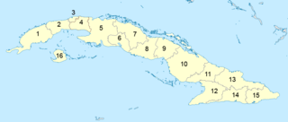
Administratively, Cuba is divided into 15 provinces and one special municipality. The current structure has been in place since August 2010, when the then-La Habana Province was divided into Artemisa Province and Mayabeque Province.

<span class="mw-page-title-main">Placetas</span> Municipality in Villa Clara, Cuba

Placetas is a city in the Villa Clara Province in the center of Cuba; before the change in the country's government in 1959 the province was called Las Villas. The town is also known as La Villa de los Laureles because of its wild laurel trees. Placetas is also a municipio, one of 13 subdivisions of the Villa Clara Province. Cuba's geographical center, Guaracabulla, is located in this municipality.

<span class="mw-page-title-main">Gerardo Machado</span> President of Cuba from 1925 to 1933

Gerardo Machado y Morales was a general of the Cuban War of Independence and President of Cuba from 1925 to 1933.

<span class="mw-page-title-main">Baracoa</span> Municipality in Guantánamo, Cuba

Baracoa, whose full original name is: Nuestra Señora de la Asunción de Baracoa, is a municipality and city in Guantánamo Province near the eastern tip of Cuba. It was visited by Admiral Christopher Columbus on November 27, 1492, and then founded by the first governor of Cuba, the Spanish conquistador Diego Velázquez de Cuéllar on August 15, 1511. It is the oldest Spanish settlement in Cuba and was its first capital.

<span class="mw-page-title-main">Santa Clara, Cuba</span> City in Villa Clara, Cuba

Santa Clara is the capital city of the Cuban province of Villa Clara. It is centrally located in the province and Cuba. Santa Clara is the fifth-most populous Cuban city, with a population of nearly 250,000.

<span class="mw-page-title-main">Bauta, Cuba</span> Municipality in Artemisa, Cuba

Bauta is a municipality and town located 40 km (25 mi) southwest of Havana City, in the Artemisa Province of Cuba since 2010 as a result of the division of what was the Province of Havana.

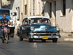
Cuban infrastructure is significant and includes: massive Spanish fortifications built in principal ports.

<span class="mw-page-title-main">Sandino, Cuba</span> Municipality in Pinar del Río, Cuba

Sandino is a municipality and town in the Pinar del Río Province of Cuba. The town is located close to the coast and as such, fishing is the main economic resource of this place. It is also the gateway to the Guanahacabibes Peninsula, a UNESCO Biosphere Reserve.

<span class="mw-page-title-main">Caimito, Cuba</span> Municipality in Artemisa, Cuba

Caimito is a municipality and town in Artemisa Province of Cuba. The town was founded in 1820. The municipality of Caimito del Guayabal was created in 1910, based on the previously existing (1879–1902) municipality of Guayabal in the Pinar del Río Province. Since 1976, the official name is Caimito.

<span class="mw-page-title-main">Ranchuelo</span> Municipality in Villa Clara, Cuba

Ranchuelo is a town and municipality in the Villa Clara Province of Cuba. It was founded in 1734 and has a municipal population of 59,062, of which about 16,804 in the town itself.

<span class="mw-page-title-main">La Fe (Sandino)</span> Village in Pinar del Río, Cuba

La Fe is a Cuban village of the municipality of Sandino, in Pinar del Río Province. It is part of the consejo popular of Cayuco.

<span class="mw-page-title-main">Esperanza (Ranchuelo)</span> Village in Villa Clara, Cuba

Esperanza, also known as La Esperanza, is a Cuban village and consejo popular of the municipality of Ranchuelo, in Villa Clara Province. With a 2011 population of 11,555 it is the most populated municipal settlement after Ranchuelo.

<span class="mw-page-title-main">Roads in Cuba</span> Highway system in Cuba

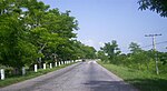
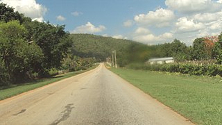
The road network of Cuba consists of 60,858 km (37,815 mi) of roads, of which over 29,850 km (18,550 mi) are paved and 31,038 km (19,286 mi) are unpaved. The Caribbean country counts also 654 km (406 mi) of motorways (autopistas).

<span class="mw-page-title-main">Autopista A1 (Cuba)</span> Motorway in Cuba

The Autopista A1, also known as Autopista Nacional, is a Cuban motorway, partly built, that will link Havana to Guantánamo. It is a toll-free road and its total length will be of about 900 km (560 mi). Along with the Autopista A4, linking Havana to Pinar del Río, it is classified as part of the whole Autopista Nacional route, spanning the length of the island; as the Carretera Central highway.

<span class="mw-page-title-main">Circuito Norte</span>

The Circuito Norte (CN), meaning "Northern Circuit", is a west-east highway spanning the length of the island of Cuba, through the Atlantic Coast. With a length of 1,222 km, it is the second-longest Cuban highway, after the "Carretera Central"; and two sections of it, named "Vía Blanca" and "Panamericana", are classified as Expressways.

<span class="mw-page-title-main">Cascajal</span> Village in Villa Clara, Cuba

Cascajal is a Cuban village and consejo popular of the municipality of Santo Domingo, in Villa Clara Province. With a 2011 population of 7,251, it is the most populated municipal settlement after Santo Domingo.

<span class="mw-page-title-main">Santa Lucía (Minas de Matahambre)</span> Village in Pinar del Río, Cuba

Santa Lucía is a Cuban village and consejo popular of the municipality of Minas de Matahambre, in Pinar del Río Province. In 2011 it had a population of 4,240.

<span class="mw-page-title-main">Circuito Sur de Oriente</span>

The Circuito Sur de Oriente (CSO), meaning "Southern Circuit of the Orient", is a west-east highway connecting Bayamo to Santiago de Cuba, through Manzanillo, Niquero and the southern coastal side of eastern Cuba, below the Sierra Maestra mountain range. Also known as Circuito Guacanayabo-Sur de Oriente, because it crosses the Gulf of Guacanayabo, the name Oriente, refers to the ancient and former Oriente Province. With a length of 347 km, it is the fourth-longest Cuban highway after the "Carretera Central", the "Circuito Norte" and the "Circuito Sur".
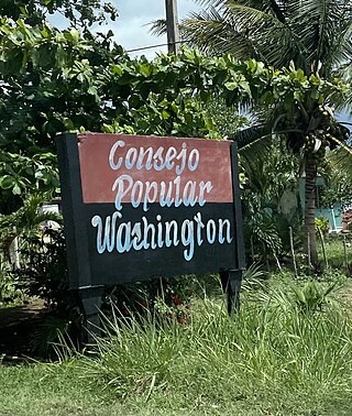
<span class="mw-page-title-main">Luis Arcos Bergnes, Cuba</span> Ward in Villa Clara, Cuba

Luis Arcos Bergnes also known as Carmita is a small town and a ward in Camajuani, Villa Clara, Cuba. With a population of 2,279 it is considered a village.

References

  1. History of Cuba - Carretera central article
  2. 1 2 Source: Mapa de Carreteras de Cuba (Road map of Cuba). Ediciones GEO, Havana 2011 - ISBN   959-7049-21-X
  3. Map and mile by mile description

22°02′32″N84°16′18″W / 22.04222°N 84.27167°W / 22.04222; -84.27167