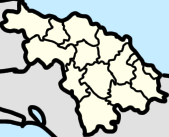
Villa Clara is one of the provinces of Cuba. It is located in the central region of the island bordering on the Atlantic Ocean to the north, Matanzas Province to the west, Sancti Spiritus Province to the east, and Cienfuegos Province to the South. Villa Clara shares with Cienfuegos and Sancti Spiritus on the south the Escambray Mountain Range. Its main cities are Santa Clara, Remedios, Sagua La Grande, Camajuani, Caibarién, Ranchuelo, Placetas, and Manicaragua.

Santa Clara is the capital city of the Cuban province of Villa Clara. It is centrally located in the province and Cuba. Santa Clara is the fifth-most populous Cuban city, with a population of nearly 245,959.

Cruces is a municipality and town in Cienfuegos Province, Cuba. It is the home of the Mal Tiempo National Park which commemorates a battle in the 1895 War of Independence.

Colón is a municipality and city in the Matanzas Province of Cuba. The municipality has an area of 547 km2 (211 sq mi) and a population of about 68,021. The city proper, with a population of about 44,000, is the third-largest of its province.

Rodas is a municipality and town in the Cienfuegos Province of Cuba. It was founded in 1859 under the name of Lechuzo. In 1879 it was renamed Rodas in honour of capitán general Caballero de Rodas.

Cabaiguán is a municipality and town in the province of Sancti Spíritus, Cuba. With an urban population of 42,075 is the 3rd largest town of the province. It is bordered to the north by the municipality of Yaguajay, to the east with the municipality of Taguasco, to the south with the municipality of Sancti Spíritus with the Tuinicú River serving as its limit, to the southwest with Fomento and to the west and northwest with Placetas, a municipality within the province of Villa Clara. It has a territorial area of 598.98 km2.

Camajuaní is a municipality and town in the Villa Clara Province of Cuba.

Palmira is a municipality and town in the Cienfuegos Province of Cuba. The whole municipality has 31,813 inhabitants.

Corralillo is a municipality and town in the Villa Clara Province of Cuba. It was founded in 1831 and established as a municipality in 1879.

Ranchuelo is a town and municipality in the Villa Clara Province of Cuba. It was founded in 1734 and has a municipal population of 50,708, of which about 15,000 in the town itself.

Santo Domingo is a municipality and town in the Villa Clara Province of Cuba.

Yaguajay is a municipality and town in the Sancti Spíritus Province of Cuba. It is located in the northern part of the province, and borders the Bay of Buena Vista to the north. The Caguanes National Park is located in Yaguajay.
Casilda is a Cuban village and consejo popular of the municipality of Trinidad, Sancti Spíritus Province.

Mataguá is a Cuban village and consejo popular of the municipality of Manicaragua, in Villa Clara Province. With a population of ca. 10,000, it is the most populated village in the municipality after Manicaragua.

Arriete-Ciego Montero, also known as Arriete or Ciego Montero, is a Cuban village, spa town, and consejo popular of the municipality of Palmira, in Cienfuegos Province. In 2011 it had a population of 4,816.

Zulueta is a Cuban village and consejo popular of the municipality of Remedios, in Villa Clara Province. It is considered the Cuban birthplace of football and, with a population of ca. 10,000 is the most populated village in the municipality after Remedios.

Jibacoa is a Cuban village and consejo popular of the municipality of Manicaragua, in Villa Clara Province. As of 2004, it had a population of 3,101; and the council's administrative territory covers an area of 78.5 km2.

Taguayabón is a Cuban village and consejo popular (ward) of the municipality of Camajuaní, in Villa Clara Province. In 2012 it had a population of 2053.

Cascajal is a Cuban village and consejo popular (ward) of the municipality of Santo Domingo, in Villa Clara Province. With a 2012 population of 5,915, it is the most populated municipal settlement after Santo Domingo.

The State Highway 4-112, also known as the Villa Clara-Cienfuegos Road, Esperanza-Cienfuegos Road, or simply the 112 is a Cuban north-south highway which links the village of Esperanza and the Carretera Central, with the Autopista A1 to the city of Cienfuegos and the Circuito Sur. The road is considered the interprovincial road of Cienfuegos Province, with it being the only road to directly connect it to the Carretera Central.