Ranchuelo

Last updated
Ranchuelo
Ranchuelo Ayuntamiento.jpg
Town hall
Ranchuelo (Cuban municipal map).png
Ranchuelo municipality (red) within
Villa Clara Province (yellow) and Cuba
Coordinates: 22°22′35.2″N80°09′03.6″W / 22.376444°N 80.151000°W / 22.376444; -80.151000
Country Cuba
Province Villa Clara
Founded1734 [1]
Established1879 (Municipality)
Area
[2]
  Total556 km2 (215 sq mi)
Elevation
125 m (410 ft)
Population
 (2022) [3]
  Total50,708
  Density91/km2 (240/sq mi)
Time zone UTC-5 (EST)
Area code +53-422

Ranchuelo is a town and municipality in the Villa Clara Province of Cuba. It was founded in 1734 [1] and has a municipal population of 50,708, of which about 15,000 in the town itself.

Contents

History

Originally named Boca de Ranchuelo, the settlement was founded by Dionisio Consuegra on October 1, 1734. In 1856 it was linked to the national rail network, and in 1879 gained the municipal status. [1]

Geography

Jose Marti Square Ranchuelo Parque Marti.jpg
José Martí Square
Jicotea sign leading into the village on the Carretera Central del Cuba highway. Jicotea City Limits Sign.jpg
Jicotea sign leading into the village on the Carretera Central del Cuba highway.

The town is divided into the barrios of Norte, Poza de la China, Sitio Viejo and Sur. [1]

Ranchuelo is 7 km from San Juan de los Yeras, 9 from Esperanza, 16 from Cruces, 28 from Santa Clara, 43 from Cienfuegos and 256 from Havana. It borders with the municipalities of Santo Domingo, Cifuentes, Santa Clara, Manicaragua, Cruces and Lajas. [4]

Demographics

In 2022, the municipality of Ranchuelo had a population of 50,708. [3] With a total area of 556 km2 (215 sq mi), [2] it has a population density of 106.2/km2 (275/sq mi).

Transport

Ranchuelo is served by the A1 motorway at the homonym exit, also known as "Ranchuelo-Cienfuegos". [5] It counts a railway station on the Santa Clara-Cienfuegos line, that is also the western terminus of a freight line to Mataguá. [6]

Esperanza, the most populated municipal hamlet, is crossed in the middle by the "Carretera Central" state highway.

Notable people

See also

Related Research Articles

<span class="mw-page-title-main">Santa Clara, Cuba</span> City in Villa Clara, Cuba

Santa Clara is the capital city of the Cuban province of Villa Clara. It is centrally located in the province and Cuba. Santa Clara is the fifth-most populous Cuban city, with a population of nearly 245,959.

<span class="mw-page-title-main">Nuevitas</span> Municipality in Camagüey, Cuba

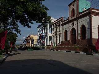
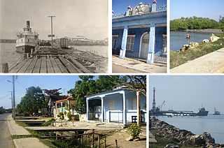
Nuevitas is a municipality and port town in the Camagüey Province of Cuba. The large bay was sighted by Christopher Columbus in 1492.

<span class="mw-page-title-main">Cruces, Cuba</span> Municipality in Cienfuegos, Cuba

Cruces is a municipality and town in Cienfuegos Province, Cuba. It is the home of the Mal Tiempo National Park which commemorates a battle in the 1895 War of Independence.

<span class="mw-page-title-main">Santa Cruz del Norte</span> Municipality in Mayabeque, Cuba

Santa Cruz del Norte is a town and municipality in the Mayabeque Province of Cuba. Before 2011 it was part of La Habana Province. It is located on the north shore, between the cities of Havana and Matanzas, at the mouth of the Santa Cruz River.

<span class="mw-page-title-main">Palma Soriano</span> District in Oriente, Cuba

Palma Soriano is a Cuban city and municipality in the Santiago de Cuba Province. With a population of 119,740 in the city proper, it is the second-largest in the province and the 16th-largest in Cuba.

<span class="mw-page-title-main">Florida, Cuba</span> Municipality in Camagüey, Cuba

Florida is a municipality and city in the Camagüey Province of Cuba. It is located 40 km (25 mi) north-west of Camagüey, along the Carretera Central highway. The city was established in 1907, and the municipality was established in 1924. Of all the municipalities of the Cuban province of Camagüey, Florida is third in area size. The name is Spanish for Land of flowers.

<span class="mw-page-title-main">Colón, Cuba</span> Municipality in Matanzas, Cuba

Colón is a municipality and city in the Matanzas Province of Cuba. The municipality has an area of 547 km2 (211 sq mi) and a population of about 68,021. The city proper, with a population of about 44,000, is the third-largest of its province.

<span class="mw-page-title-main">Aguada de Pasajeros</span> Municipality in Cienfuegos, Cuba

Aguada de Pasajeros is a municipality and town in the Cienfuegos Province of Cuba.

<span class="mw-page-title-main">Rodas</span> Municipality in Cienfuegos, Cuba

Rodas is a municipality and town in the Cienfuegos Province of Cuba. It was founded in 1859 under the name of Lechuzo. In 1879 it was renamed Rodas in honour of capitán general Caballero de Rodas.

<span class="mw-page-title-main">Camajuaní</span> Municipality in Villa Clara, Cuba

Camajuaní is a municipality and town in the Villa Clara Province of Cuba.

<span class="mw-page-title-main">Cumanayagua</span> Municipality in Cienfuegos, Cuba

Cumanayagua is a municipality and town in the Cienfuegos Province of Cuba. It is located in a valley near the Guamuhaya Mountains (usually these mountains are referred as Escambray Mountains, 23 kilometres east of Cienfuegos, the provincial capital.

<span class="mw-page-title-main">Lajas, Cuba</span> Municipality in Cienfuegos, Cuba

Lajas, known historically and culturally as Santa Isabel de las Lajas, is a municipality and town in the Cienfuegos Province of Cuba. It is located in the northern part of the province, 35 kilometres (22 mi) west of Santa Clara and immediately south of the A1 motorway.

<span class="mw-page-title-main">Palmira, Cuba</span> Municipality in Cienfuegos, Cuba

Palmira is a municipality and town in the Cienfuegos Province of Cuba. The whole municipality has 31,813 inhabitants.

<span class="mw-page-title-main">Batabanó, Cuba</span> Municipality in Mayabeque, Cuba

Batabanó is a municipality and town in the Mayabeque Province of Cuba. It was founded in 1688.

<span class="mw-page-title-main">Nueva Paz</span> Municipality in Mayabeque, Cuba

Nueva Paz is a municipality and town in the Mayabeque Province of Cuba. It was founded in 1802.

<span class="mw-page-title-main">Corralillo</span> Municipality in Villa Clara, Cuba

Corralillo is a municipality and town in the Villa Clara Province of Cuba. It was founded in 1831 and established as a municipality in 1879.

<span class="mw-page-title-main">Santo Domingo, Cuba</span> Municipality in Villa Clara, Cuba

Santo Domingo is a municipality and town in the Villa Clara Province of Cuba.

<span class="mw-page-title-main">Yaguajay, Cuba</span> Municipality in Sancti Spíritus, Cuba

Yaguajay is a municipality and town in the Sancti Spíritus Province of Cuba. It is located in the northern part of the province, and borders the Bay of Buena Vista to the north. The Caguanes National Park is located in Yaguajay.

<span class="mw-page-title-main">Esperanza (Ranchuelo)</span> Village in Villa Clara, Cuba

Esperanza, also known as La Esperanza, is a Cuban village and consejo popular of the municipality of Ranchuelo, in Villa Clara Province. It is the most populated municipal settlement after Ranchuelo.

<span class="mw-page-title-main">Arriete-Ciego Montero</span> Village in Cienfuegos, Cuba

Arriete-Ciego Montero, also known as Arriete or Ciego Montero, is a Cuban village, spa town, and consejo popular of the municipality of Palmira, in Cienfuegos Province. In 2011 it had a population of 4,816.

References

  1. 1 2 3 4 Guije.com. "Ranchuelo" (in Spanish). Retrieved 2007-10-09.
  2. 1 2 Statoids (July 2003). "Municipios of Cuba" . Retrieved 2007-10-09.
  3. 1 2 "Cuba: Administrative Division (Provinces and Municipalities) - Population Statistics, Charts and Map". www.citypopulation.de. Retrieved 2024-02-03.
  4. 5884799 (x a j h) Ranchuelo on OpenStreetMap
  5. 1308266444 Ranchuelo (A1 exit) on OpenStreetMap
  6. 2925075943 Ranchuelo railway station on OpenStreetMap