Corralillo

Last updated
Corralillo
Central Azucarero Quintin Banderas, Corralillo, Cuba.jpg
Sugar mill Quintin Banderas, located in the municipality
Corralillo (Cuban municipal map).png
Corralillo municipality (red) within
Villa Clara Province (yellow) and Cuba
Coordinates: 22°59′8″N80°34′59″W / 22.98556°N 80.58306°W / 22.98556; -80.58306
Country Cuba
Province Villa Clara
Founded1831 [1]
Established1879 (Municipality)
Area
[2]
  Total843 km2 (325 sq mi)
Elevation
15 m (49 ft)
Population
 (2022)
  Total24,791
  Density29/km2 (76/sq mi)
Time zone UTC-5 (EST)
Area code +53-42

Corralillo is a municipality and town in the Villa Clara Province of Cuba. It was founded in 1831 [1] and established as a municipality in 1879.

Contents

Geography

Corralillo is located on the northern coast of Cuba, in the north-western corner of the Villa Clara province, bordering the Matanzas Province to the west and the Bay of Cadiz to the north. The cays of Falcones, Blanquizal and Verde of the Sabana-Camagüey Archipelago as well as a multitude of reefs are located at sea north of Corralillo. [3]

The municipality is divided into the consejos populares (mainly villages) of Ceja de Pablo, Corralillo (municipal seat), Palma Sola, Perú, Rancho Veloz, Sabana Grande, Santa María and Sierra Morena. [1]

Demographics

In 2022, the municipality of Corralillo had a population of 24,791. [4] With a total area of 843 km2 (325 sq mi), [2] it has a population density of 29/km2 (75/sq mi).

Institutions

See also

Related Research Articles

<span class="mw-page-title-main">Villa Clara Province</span> Province of Cuba

Villa Clara is one of the provinces of Cuba. It is located in the central region of the island bordering on the Atlantic Ocean to the north, Matanzas Province to the west, Sancti Spiritus Province to the east, and Cienfuegos Province to the South. Villa Clara shares with Cienfuegos and Sancti Spiritus on the south the Escambray Mountain Range. Its main cities are Santa Clara, Remedios, Sagua La Grande, Camajuani, Caibarién, Ranchuelo, Placetas, and Manicaragua.

<span class="mw-page-title-main">Matanzas Province</span> Province of Cuba

Matanzas is one of the provinces of Cuba. Major towns in the province include Cárdenas, Colón, Jovellanos and the capital of the same name, Matanzas. The resort town of Varadero is also located in this province.

<span class="mw-page-title-main">Cienfuegos Province</span> Province of Cuba

Cienfuegos is one of the provinces of Cuba. The capital city of the province is also called Cienfuegos and was founded by French settlers in 1819.

<span class="mw-page-title-main">Holguín</span> Municipality in Cuba

Holguín is a municipality-city in Cuba. After Havana, Santiago de Cuba, and Camagüey, it is the fourth largest city in Cuba.

<span class="mw-page-title-main">Bauta, Cuba</span> Municipality in Artemisa, Cuba

Bauta is a municipality and town located 40 km (25 mi) southwest of Havana City, in the Artemisa Province of Cuba since 2010 as a result of the division of what was the Province of Havana.

<span class="mw-page-title-main">Colón, Cuba</span> Municipality in Matanzas, Cuba

Colón is a municipality and city in the Matanzas Province of Cuba. The municipality has an area of 547 km2 (211 sq mi) and a population of about 68,021. The city proper, with a population of about 44,000, is the third-largest of its province.

<span class="mw-page-title-main">Los Arabos</span> Municipality in Matanzas, Cuba

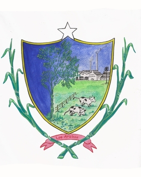
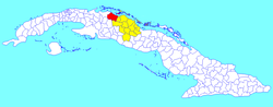
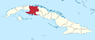
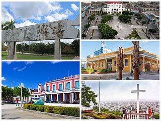
Los Arabos is a municipality and town in the Matanzas Province of Cuba. It is located in the eastern part of the province, bordering the province of Villa Clara.

<span class="mw-page-title-main">Remedios, Cuba</span> Municipality in Villa Clara, Cuba

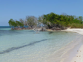
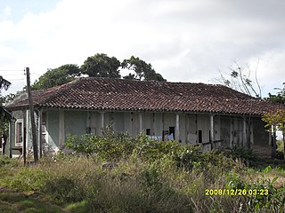
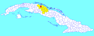
Remedios, also known as San Juan de los Remedios, is a city and municipality located 3 miles (4.8 km) from the northern coast of Cuba, in the center of the island. It is the oldest Spanish settlement in the former Las Villas province. It is now part of the province of Villa Clara.

<span class="mw-page-title-main">Camajuaní</span> Municipality in Villa Clara, Cuba

Camajuaní is a municipality and town in the Villa Clara Province of Cuba.

<span class="mw-page-title-main">Minas de Matahambre</span> Municipality in Pinar del Río, Cuba

Minas de Matahambre is a municipality and town in the Pinar del Río Province of Cuba. It was declared a National Monument of Cuba.

<span class="mw-page-title-main">Cumanayagua</span> Municipality in Cienfuegos, Cuba

Cumanayagua is a municipality and town in the Cienfuegos Province of Cuba. It is located in a valley near the Guamuhaya Mountains (usually these mountains are referred as Escambray Mountains, 23 kilometres east of Cienfuegos, the provincial capital.

<span class="mw-page-title-main">Madruga</span> Municipality in Mayabeque, Cuba

Madruga is a municipality and town in the Mayabeque Province of Cuba. It is located in the eastern part of the province, between Matanzas and Güines. It was founded in 1803.

<span class="mw-page-title-main">Cifuentes, Cuba</span> Municipality in Villa Clara, Cuba

Cifuentes is a municipality and town in the Villa Clara Province of Cuba founded in 1819 and established as a municipality in 1919.

<span class="mw-page-title-main">Encrucijada</span> Municipality in Villa Clara, Cuba

Encrucijada is a municipality and town in the Villa Clara Province of Cuba. It was founded in 1850 and established as a municipality in 1910.

<span class="mw-page-title-main">Manicaragua</span> Municipality in Villa Clara, Cuba

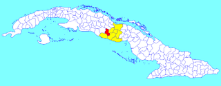
Manicaragua is a municipality and mountain town in the Villa Clara Province of Cuba. It is located in the Escambray Mountains at the southern part of Villa Clara, bordering the provinces of Cienfuegos to the west and Sancti Spíritus to the east.

<span class="mw-page-title-main">Quemado de Güines</span> Municipality in Villa Clara, Cuba

Quemado de Güines is a municipality and town in the Villa Clara Province of Cuba. It was founded in 1667.

<span class="mw-page-title-main">Ranchuelo</span> Municipality in Villa Clara, Cuba

Ranchuelo is a town and municipality in the Villa Clara Province of Cuba. It was founded in 1734 and has a municipal population of 50,708, of which about 15,000 in the town itself.

<span class="mw-page-title-main">Santo Domingo, Cuba</span> Municipality in Villa Clara, Cuba

Santo Domingo is a municipality and town in the Villa Clara Province of Cuba.

<span class="mw-page-title-main">Fomento</span> Municipality in Sancti Spíritus, Cuba

Fomento is a town and municipality in the Sancti Spíritus Province of Cuba. It was founded in 1864.

<span class="mw-page-title-main">Songo – La Maya</span> Municipality in Santiago de Cuba, Cuba

Songo – La Maya is a municipality in the Santiago de Cuba Province of Cuba. It is located north-east of Santiago de Cuba and is centered on the towns of La Maya and Alto Songo.

References

  1. 1 2 3 "Corralillo". guije.com (in Spanish). Retrieved 2007-10-09.[ dead link ]
  2. 1 2 Statoids (July 2003). "Municipios of Cuba" . Retrieved 2007-10-09.
  3. Corralillo", map, on openstreetmap.org.
  4. "Cuba: Administrative Division (Provinces and Municipalities) - Population Statistics, Charts and Map". www.citypopulation.de. Retrieved 2024-02-03.

Commons-logo.svg Media related to Corralillo at Wikimedia Commons