Artemisa Province | |
|---|---|
 Coat of arms | |
 | |
| Coordinates: 22°48′49″N82°45′48″W / 22.81361°N 82.76333°W | |
| Country | Cuba |
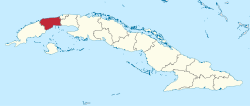
| Capital | Artemisa |
| Municipalities | Mariel, Guanajay, Caimito, Bauta, San Antonio de los Baños, Güira de Melena, Alquízar, Artemisa, Candelaria, San Cristóbal, Bahía Honda |
| Government | |
| • Governor | Ricardo Concepción Rodríguez |
| • Vice-Governor | Yamina Duarte Duarte |
| Area | |
• Total | 4,004.27 km2 (1,546.06 sq mi) |
| Highest elevation | 681 m (2,234 ft) |
| Population (2010-12-31) [1] | |
• Total | 502,312 |
| • Density | 125.444/km2 (324.899/sq mi) |
| Time zone | UTC−5 (EST) |
| Area code | +53-47 |
| ISO 3166 code | CU-15 |
| HDI (2019) | 0.797 [2] high · 3rd of 16 |
| Website | www.artemisa.gob.cu/es/ |
Artemisa Province is one of the two new provinces created from the former La Habana Province, whose creation was approved by the Cuban National Assembly on August 1, 2010, the other being Mayabeque Province. [3] [4] [5] The new provinces came into existence on January 1, 2011.

