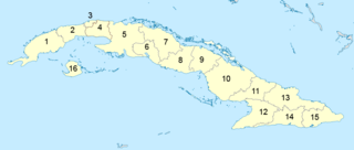
Administratively, Cuba is divided into 15 provinces and one special municipality. The current structure has been in place since August 2010, when the then-La Habana Province was divided into Artemisa Province and Mayabeque Province.

Villa Clara is one of the provinces of Cuba. It is located in the central region of the island bordering on the Atlantic Ocean to the north, Matanzas Province to the west, Sancti Spiritus Province to the east, and Cienfuegos Province to the South. Villa Clara shares with Cienfuegos and Sancti Spiritus on the south the Escambray Mountain Range. Its main cities are Santa Clara, Remedios, Sagua La Grande, Camajuani, Caibarién, Ranchuelo, Placetas, and Manicaragua.

The Carretera Central (CC), meaning "Central Road", is a west-east highway spanning the length of the island of Cuba.

Santa Clara is the capital city of the Cuban province of Villa Clara. It is centrally located in the province and Cuba. Santa Clara is the fifth-most populous Cuban city, with a population of nearly 250,000.

Colón is a municipality and city in the Matanzas Province of Cuba. The municipality has an area of 547 km2 (211 sq mi) and a population of about 71,000. The city proper, with a population of about 44,000, is the third-largest of its province.

Rodas is a municipality and town in the Cienfuegos Province of Cuba. It was founded in 1859 under the name of Lechuzo. In 1879 it was renamed Rodas in honour of capitán general Caballero de Rodas.
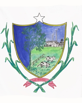
Los Arabos is a municipality and town in the Matanzas Province of Cuba. It is located in the eastern part of the province, bordering the province of Villa Clara.

Corralillo is a municipality and town in the Villa Clara Province of Cuba. It was founded in 1831 and established as a municipality in 1879.

Ranchuelo is a town and municipality in the Villa Clara Province of Cuba. It was founded in 1734 and has a municipal population of 59,062, of which about 16,804 in the town itself.

Santo Domingo is a municipality and town in the Villa Clara Province of Cuba.

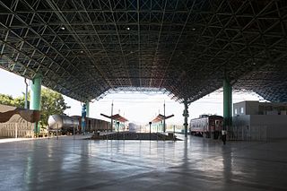
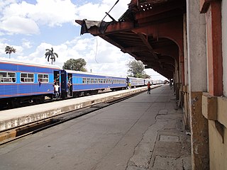
Santa Clara is the main railway station of the city of Santa Clara, seat of Villa Clara Province, Cuba. It is owned by the state company Ferrocarriles de Cuba (FFCC) and is located in front of Parque de los Mártires. It is one of the most important stations of Cuba and, along with Havana Central, Santiago and Camagüey, is a network's divisional headquarters.

Esperanza, also known as La Esperanza, is a Cuban village and consejo popular of the municipality of Ranchuelo, in Villa Clara Province. It is the most populated municipal settlement after Ranchuelo.

Mataguá is a Cuban village and consejo popular of the municipality of Manicaragua, in Villa Clara Province. With a population of ca. 10,000, it is the most populated village in the municipality after Manicaragua.

The road network of Cuba consists of 60,858 km (37,815 mi) of roads, of which over 29,850 km (18,550 mi) are paved and 31,038 km (19,286 mi) are unpaved. The Caribbean country counts also 654 km (406 mi) of motorways (autopistas).
Santiago de Cuba, also known as Santiago General Senén Casas, is the main railway station of the city of Santiago de Cuba, seat of the homonym province, Cuba. It is owned by the state company Ferrocarriles de Cuba (FFCC) and is located in the central Paseo de Martí, nearby the city harbor.
Camagüey is the main railway station of the city of Camagüey, seat of the homonym province, Cuba. The station, informally known as Camagüey Central, is owned by the state company Ferrocarriles de Cuba (FFCC) and is located in the Avenida Van Horne, in the middle of the city and just in front of the Hotel Plaza.

Zulueta is a Cuban village and consejo popular of the municipality of Remedios, in Villa Clara Province. It is considered the Cuban birthplace of football and, with a population of ca. 10,000 is the most populated village in the municipality after Remedios.

Mir is a Cuban village and consejo popular of the municipality of Calixto García, in Holguín Province. In 2011 it had a population of 6,647.
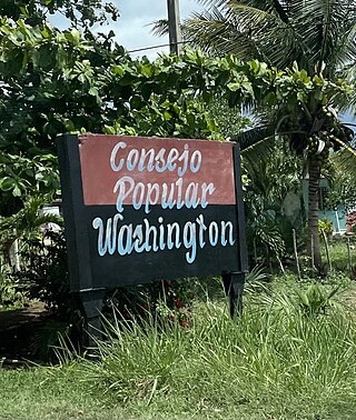
In Cuba, a consejo popular is an electoral ward or political-administrative demarcation of the National Assembly of People's Power of Cuba.


